
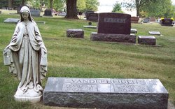
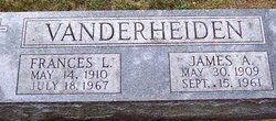
James Anthony Vanderheiden
| Birth | : | 30 May 1909 Armour, Douglas County, South Dakota, USA |
| Death | : | 15 Sep 1961 Carroll County, Iowa, USA |
| Burial | : | Mount Olivet Cemetery, Carroll, Carroll County, USA |
| Coordinate | : | 42.0536340, -94.8595510 |
| Description | : | September 16, 1961 - Carroll Daily Times - James A. Vanderheiden, 51, Carroll County bridge foreman, was accidentally killed by an electric shock about 1:15 p.m. Friday while supervising work on the Hansman bridge two miles north of Willey, Dr. Roland B. Morrison, County Medical Examiner, reported. Mr. Vanderheiden was standing behind a boom truck, operated by Joseph Heller Jr., and apparently accidentally touched the truck as the boom came in contact with a 6,600 volt IPS power line, Dr. Morrison said. The medical examination showed Mr. Vanderheiden's left hand was burned and the soles of his shoes were charred... Read More |
frequently asked questions (FAQ):
-
Where is James Anthony Vanderheiden's memorial?
James Anthony Vanderheiden's memorial is located at: Mount Olivet Cemetery, Carroll, Carroll County, USA.
-
When did James Anthony Vanderheiden death?
James Anthony Vanderheiden death on 15 Sep 1961 in Carroll County, Iowa, USA
-
Where are the coordinates of the James Anthony Vanderheiden's memorial?
Latitude: 42.0536340
Longitude: -94.8595510
Family Members:
Parent
Spouse
Siblings
Flowers:


Nearby Cemetories:
1. Mount Olivet Cemetery
Carroll, Carroll County, USA
Coordinate: 42.0536340, -94.8595510
2. Carroll City Cemetery
Carroll, Carroll County, USA
Coordinate: 42.0560963, -94.8599856
3. Holy Angels Cemetery
Carroll County, USA
Coordinate: 42.0014000, -94.9141998
4. Saint Francis Cemetery
Maple River, Carroll County, USA
Coordinate: 42.0969009, -94.9372025
5. Saint Marys Catholic Cemetery
Willey, Carroll County, USA
Coordinate: 41.9783363, -94.8212204
6. Holy Family Cemetery
Lidderdale, Carroll County, USA
Coordinate: 42.1178017, -94.7839966
7. West Lawn Cemetery
Glidden, Carroll County, USA
Coordinate: 42.0649986, -94.7406006
8. Immanuel Cemetery
Lidderdale, Carroll County, USA
Coordinate: 42.1389008, -94.8022003
9. Saint Augustine Cemetery
Halbur, Carroll County, USA
Coordinate: 42.0066986, -94.9744034
10. Our Lady Of Mount Carmel Cemetery
Mount Carmel, Carroll County, USA
Coordinate: 42.1547012, -94.9088974
11. Arcadia Cemetery
Arcadia Township, Carroll County, USA
Coordinate: 42.1000680, -95.0130550
12. East Liberty Cemetery
Lidderdale, Carroll County, USA
Coordinate: 42.1591988, -94.7636032
13. McCurdy Cemetery
Carroll County, USA
Coordinate: 41.9403000, -94.7649994
14. Saint Johns Catholic Cemetery
Arcadia, Carroll County, USA
Coordinate: 42.0855406, -95.0341577
15. Dickson Cemetery
Glidden Township, Carroll County, USA
Coordinate: 42.1074982, -94.6939011
16. Saint Bernards Cemetery
Breda, Carroll County, USA
Coordinate: 42.1786003, -94.9732971
17. Elba Cemetery
Templeton, Carroll County, USA
Coordinate: 41.9068985, -94.9131012
18. Sacred Heart Cemetery
Templeton, Carroll County, USA
Coordinate: 41.9138746, -94.9460994
19. Dedham Cemetery
Dedham, Carroll County, USA
Coordinate: 41.8993988, -94.8225021
20. Saint Josephs Cemetery
Dedham, Carroll County, USA
Coordinate: 41.8993988, -94.8210983
21. North Coon Cemetery
Carroll County, USA
Coordinate: 42.1260986, -94.6716995
22. Old Carrollton Cemetery
Carrollton, Carroll County, USA
Coordinate: 41.9233017, -94.7403030
23. Lanesboro Cemetery
Lanesboro, Carroll County, USA
Coordinate: 42.1810989, -94.7230988
24. Luckow Cemetery
Auburn, Sac County, USA
Coordinate: 42.2168999, -94.9266968