


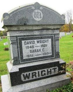
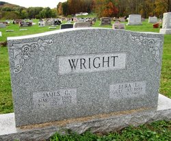
James Calvin Wright
| Birth | : | 25 Mar 1889 |
| Death | : | 22 May 1967 |
| Burial | : | Saint Marys Cemetery, Bronson, Branch County, USA |
| Coordinate | : | 41.8582993, -85.1939011 |
| Description | : | In 1900 he and his parents and brother lived on a farm they owned, with a mortgage, in Perry Township, Licking County, OH. In 1910 he and his parents lived on a farm they owned, mortgage free, in the same township. It is not known whether it was the same farm they had lived on in 1900. In 1920 he and his wife and their son lived on a farm they were renting--probably from his father--in the same township. In 1930 they lived on presumably the same farm, on Smith's Chapel and Rocky Ford Road. They did have a radio. In 1940 he and... Read More |
frequently asked questions (FAQ):
-
Where is James Calvin Wright's memorial?
James Calvin Wright's memorial is located at: Saint Marys Cemetery, Bronson, Branch County, USA.
-
When did James Calvin Wright death?
James Calvin Wright death on 22 May 1967 in
-
Where are the coordinates of the James Calvin Wright's memorial?
Latitude: 41.8582993
Longitude: -85.1939011
Family Members:
Parent

Spouse
Siblings

Children
Flowers:


Nearby Cemetories:
1. Saint Marys Cemetery
Bronson, Branch County, USA
Coordinate: 41.8582993, -85.1939011
2. Bronson Cemetery
Bronson, Branch County, USA
Coordinate: 41.8699340, -85.1858320
3. Snow Prairie Cemetery
Bethel, Branch County, USA
Coordinate: 41.8699989, -85.1408005
4. Curtis Cemetery
Bronson, Branch County, USA
Coordinate: 41.8039017, -85.1956024
5. North Gilead Cemetery
Gilead Township, Branch County, USA
Coordinate: 41.8039017, -85.1557999
6. York Cemetery
Batavia, Branch County, USA
Coordinate: 41.9009350, -85.1318550
7. Pleasant Hill Cemetery
Noble Township, Branch County, USA
Coordinate: 41.7961110, -85.2111110
8. Adams Cemetery
Bronson, Branch County, USA
Coordinate: 41.8405991, -85.2767029
9. Dutch Settlement Cemetery
Bronson, Branch County, USA
Coordinate: 41.8106003, -85.2632980
10. Matteson Cemetery
Matteson, Branch County, USA
Coordinate: 41.9406013, -85.2046967
11. South Gilead Cemetery
Bronson, Branch County, USA
Coordinate: 41.7733330, -85.1566670
12. Card Cemetery
Bethel Township, Branch County, USA
Coordinate: 41.8544006, -85.0693970
13. Batavia Cemetery
Batavia, Branch County, USA
Coordinate: 41.9202778, -85.0975000
14. Sanborn Cemetery
Burr Oak, St. Joseph County, USA
Coordinate: 41.8708000, -85.3305969
15. Burr Oak Township Cemetery
Burr Oak, St. Joseph County, USA
Coordinate: 41.8472214, -85.3319473
16. Trayer Cemetery
Bronson, Branch County, USA
Coordinate: 41.7705550, -85.2677770
17. South Colon Cemetery
Colon, St. Joseph County, USA
Coordinate: 41.9199982, -85.3114014
18. Ovid Cemetery
Ovid Township, Branch County, USA
Coordinate: 41.8688580, -85.0484920
19. East Gilead Cemetery
East Gilead, Branch County, USA
Coordinate: 41.7858330, -85.0825000
20. Eroh Cemetery
Fawn River Township, St. Joseph County, USA
Coordinate: 41.8081017, -85.3375015
21. Freedom Cemetery
Fawn River, St. Joseph County, USA
Coordinate: 41.8064003, -85.3371964
22. Tripp Cemetery
Batavia, Branch County, USA
Coordinate: 41.9425000, -85.0694440
23. Bartholomew Cemetery
Fawn River Township, St. Joseph County, USA
Coordinate: 41.8059600, -85.3476300
24. Mill Grove Cemetery
Orland, Steuben County, USA
Coordinate: 41.7327995, -85.1718979