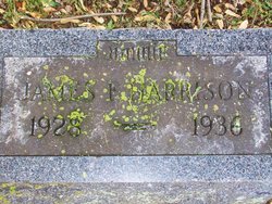
James Francis Harrison
| Birth | : | 1929 |
| Death | : | 1 Jan 1936 Lafayette, Tippecanoe County, Indiana, USA |
| Burial | : | Cotton Creek Cemetery, Jobe, Oregon County, USA |
| Coordinate | : | 36.5844002, -91.2652969 |
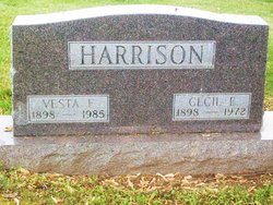
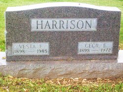
| Description | : | Funeral services for James Francis Harrison, seven-year-old sou of Mr. and Mrs. Cecil Harrison, of east Monticello, who died at St. Elizabeth hospital, Lafayette Wednesday, will be held this afternoon at the Monticello Methodist church. Interment will be in Riverview cemetery. THE LOGANSPORT PRESS SATURDAY, JAN. 4, 1936. |
frequently asked questions (FAQ):
-
Where is James Francis Harrison's memorial?
James Francis Harrison's memorial is located at: Cotton Creek Cemetery, Jobe, Oregon County, USA.
-
When did James Francis Harrison death?
James Francis Harrison death on 1 Jan 1936 in Lafayette, Tippecanoe County, Indiana, USA
-
Where are the coordinates of the James Francis Harrison's memorial?
Latitude: 36.5844002
Longitude: -91.2652969
Family Members:
Parent
Flowers:
Nearby Cemetories:
1. Cotton Creek Cemetery
Jobe, Oregon County, USA
Coordinate: 36.5844002, -91.2652969
2. Old Jobe Cemetery
Jobe, Oregon County, USA
Coordinate: 36.5917015, -91.2517014
3. O'Neal
Billmore, Oregon County, USA
Coordinate: 36.5712170, -91.2415410
4. John Brown Cemetery
Jobe, Oregon County, USA
Coordinate: 36.5812111, -91.2953568
5. Roberts Family Farm Cemetery
Couch, Oregon County, USA
Coordinate: 36.6165300, -91.2401700
6. Lance Cemetery
Many Springs, Oregon County, USA
Coordinate: 36.6310997, -91.2699966
7. Guiteau-Risner Cemetery
Guiteau, Oregon County, USA
Coordinate: 36.5588074, -91.3156128
8. Garfield Cemetery
Garfield, Oregon County, USA
Coordinate: 36.5844400, -91.3253400
9. Crass Homestead
Myrtle, Oregon County, USA
Coordinate: 36.5359695, -91.3084671
10. Dobbs-LaHue Cemetery
Riverton, Oregon County, USA
Coordinate: 36.6233978, -91.1966476
11. Many Springs Cemetery
Many Springs, Oregon County, USA
Coordinate: 36.6521200, -91.2695100
12. Pigman Mound Archeological Site
Calm, Oregon County, USA
Coordinate: 36.5717100, -91.1784800
13. Myrtle Cemetery
Myrtle, Oregon County, USA
Coordinate: 36.5133900, -91.2664300
14. Spring Valley Cemetery
Billmore, Oregon County, USA
Coordinate: 36.5324670, -91.2003420
15. Byrd Cemetery
Myrtle, Oregon County, USA
Coordinate: 36.5186005, -91.3143997
16. Riverton Cemetery
Riverton, Oregon County, USA
Coordinate: 36.6476100, -91.2076900
17. Dobbs Lahue Cemetery
Riverton, Oregon County, USA
Coordinate: 36.6269300, -91.1823600
18. Old Elmore Thomas field
Billmore, Oregon County, USA
Coordinate: 36.5237770, -91.1980250
19. Church of God Cemetery
Oregon County, USA
Coordinate: 36.5023500, -91.2580200
20. Olon Tucker Farm Cemetery #2
Couch, Oregon County, USA
Coordinate: 36.5867000, -91.3705400
21. New Salem Cemetery
Couch, Oregon County, USA
Coordinate: 36.6042252, -91.3712463
22. Liberty Cemetery
Calm, Oregon County, USA
Coordinate: 36.5586500, -91.1549600
23. Arytown Cemetery
Arytown, Oregon County, USA
Coordinate: 36.5539513, -91.3795776
24. Boze Mill Cemetery
Boze Mill, Oregon County, USA
Coordinate: 36.6631126, -91.1940231


