
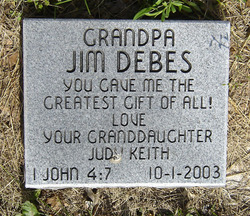

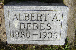
James Lawrence “Grandpa” Debes
| Birth | : | 26 May 1879 |
| Death | : | 22 Jul 1962 |
| Burial | : | Lorimor Cemetery, Lorimor, Union County, USA |
| Coordinate | : | 41.1128006, -94.0516968 |
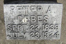
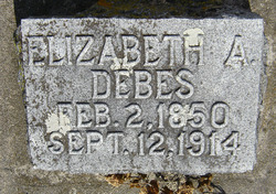
| Description | : | Son of Peter Agnethon Debes & Elizabeth Watkins. He married Mae Zella Pugh in 1909. |
frequently asked questions (FAQ):
-
Where is James Lawrence “Grandpa” Debes's memorial?
James Lawrence “Grandpa” Debes's memorial is located at: Lorimor Cemetery, Lorimor, Union County, USA.
-
When did James Lawrence “Grandpa” Debes death?
James Lawrence “Grandpa” Debes death on 22 Jul 1962 in
-
Where are the coordinates of the James Lawrence “Grandpa” Debes's memorial?
Latitude: 41.1128006
Longitude: -94.0516968
Family Members:
Parent
Spouse
Siblings

Children
Flowers:


Nearby Cemetories:
1. Lorimor Cemetery
Lorimor, Union County, USA
Coordinate: 41.1128006, -94.0516968
2. Monette Cemetery
Lorimor, Union County, USA
Coordinate: 41.0800743, -94.0715866
3. Groesbeck Cemetery
Lorimor, Union County, USA
Coordinate: 41.1100006, -94.1230011
4. Bethel Cemetery
Thayer, Union County, USA
Coordinate: 41.0600014, -94.0693970
5. Barney Cemetery
Monroe Township, Madison County, USA
Coordinate: 41.1641998, -94.0239029
6. Beulah Cemetery
Thayer, Union County, USA
Coordinate: 41.0589981, -94.0759964
7. Bragg Cemetery
Lorimor, Union County, USA
Coordinate: 41.1282997, -94.1433029
8. Mount Pisgah Cemetery
Thayer, Union County, USA
Coordinate: 41.0511017, -94.1007996
9. Browns Mountain Cemetery
Thayer, Union County, USA
Coordinate: 41.0499992, -94.0999985
10. Thayer Catholic Cemetery
Thayer, Union County, USA
Coordinate: 41.0374985, -94.0357971
11. Bullock Cemetery
Monroe Township, Madison County, USA
Coordinate: 41.1960983, -94.0650024
12. West Union Cemetery
Thayer, Union County, USA
Coordinate: 41.0191994, -94.0721970
13. Dodge Center Cemetery
Afton, Union County, USA
Coordinate: 41.1279984, -94.1829987
14. Claypool Cemetery
Thayer, Union County, USA
Coordinate: 41.0126114, -94.0303497
15. Union Cemetery
Murray, Clarke County, USA
Coordinate: 41.1265000, -93.9115000
16. Bell Family Cemetery
Murray, Clarke County, USA
Coordinate: 41.0625267, -93.9240036
17. Hamblin Cemetery
Monroe Township, Madison County, USA
Coordinate: 41.2214012, -94.0958023
18. Murray Cemetery
Murray, Clarke County, USA
Coordinate: 41.0278015, -93.9456024
19. Otterbein Cemetery
Thayer, Union County, USA
Coordinate: 40.9990005, -94.0879974
20. Clark Cemetery
Monroe Township, Madison County, USA
Coordinate: 41.2364006, -94.0733032
21. Moon Cemetery
Grand River Township, Madison County, USA
Coordinate: 41.1935997, -94.1810989
22. Cedar Grove Cemetery
Lorimor, Union County, USA
Coordinate: 41.1209984, -94.2200012
23. Greenlawn Cemetery
Afton, Union County, USA
Coordinate: 41.0335999, -94.1856003
24. Civil War Era Cemetery
Afton, Union County, USA
Coordinate: 41.0460854, -94.2025299