
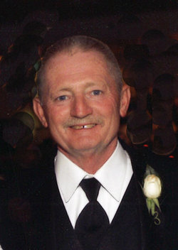
James Lee “Jim” Chesnut
| Birth | : | 3 Oct 1951 Waverly, Bremer County, Iowa, USA |
| Death | : | 19 Nov 2013 Charles City, Floyd County, Iowa, USA |
| Burial | : | Harlington Cemetery, Waverly, Bremer County, USA |
| Coordinate | : | 42.7158012, -92.4721985 |
| Description | : | son of Reid Leroy and Mary Ellen (Ingersoll) Chesnut Viet Nam war veteran James Lee "Jim" Chesnut, 62, of Clarksville, Iowa, was pronounced dead early Tuesday morning, November 19, 2013, at the Floyd County Hospital, Charles City, Iowa, from complications of a pulmonary embolism. Jim was born on October 3, 1951, in Waverly, Iowa, the son of Reid Leroy Chesnut and Mary Ellen (Ingersoll) Brown. He attended the Clarksville school system, graduating in 1969, from the Clarksville High School. Following his schooling, Jim worked for the Voss's Mill Elevator in Clarksville, and on February 3, 1971, he entered the U.S. Army during the Vietnam... Read More |
frequently asked questions (FAQ):
-
Where is James Lee “Jim” Chesnut's memorial?
James Lee “Jim” Chesnut's memorial is located at: Harlington Cemetery, Waverly, Bremer County, USA.
-
When did James Lee “Jim” Chesnut death?
James Lee “Jim” Chesnut death on 19 Nov 2013 in Charles City, Floyd County, Iowa, USA
-
Where are the coordinates of the James Lee “Jim” Chesnut's memorial?
Latitude: 42.7158012
Longitude: -92.4721985
Family Members:
Parent
Flowers:


Nearby Cemetories:
1. Peace United Church of Christ Cemetery
Waverly, Bremer County, USA
Coordinate: 42.7192630, -92.4543880
2. Saint Pauls Lutheran Cemetery
Waverly, Bremer County, USA
Coordinate: 42.7188988, -92.4539032
3. Saint Josephs Cemetery
Waverly, Bremer County, USA
Coordinate: 42.7200012, -92.4539032
4. Saint Marys Cemetery
Waverly, Bremer County, USA
Coordinate: 42.7275009, -92.4563980
5. Town Line Cemetery
Waverly, Bremer County, USA
Coordinate: 42.7443650, -92.4353380
6. Pilot Mound Cemetery
Janesville, Bremer County, USA
Coordinate: 42.6856003, -92.5141983
7. Oakland Cemetery
Janesville, Bremer County, USA
Coordinate: 42.6558930, -92.4559700
8. Andrews Cemetery
Waverly, Bremer County, USA
Coordinate: 42.7771988, -92.4772034
9. Spring Lake Cemetery
Waverly, Bremer County, USA
Coordinate: 42.7742004, -92.5147018
10. West Point Cemetery
Bremer County, USA
Coordinate: 42.6680984, -92.5346985
11. Warren Evangelical Cemetery
Waverly, Bremer County, USA
Coordinate: 42.7442200, -92.3867400
12. Newell Cemetery
Black Hawk County, USA
Coordinate: 42.6333008, -92.4903030
13. Riverside Cemetery
Shell Rock, Butler County, USA
Coordinate: 42.7126600, -92.5874500
14. Finchford Cemetery
Finchford, Black Hawk County, USA
Coordinate: 42.6276400, -92.5398800
15. Saint Pauls Lutheran Cemetery
Artesian, Bremer County, USA
Coordinate: 42.7565980, -92.3376690
16. East Janesville ME Church Cemetery
Black Hawk County, USA
Coordinate: 42.6405500, -92.3573200
17. Saint Peters Lutheran Cemetery
Denver, Bremer County, USA
Coordinate: 42.6712250, -92.3290100
18. Fairview Cemetery
Denver, Bremer County, USA
Coordinate: 42.6707993, -92.3277969
19. Washington Chapel Cemetery
Cedar Falls, Black Hawk County, USA
Coordinate: 42.5991430, -92.4761210
20. Saint Pauls Evangelical Cemetery
Denver, Bremer County, USA
Coordinate: 42.6906013, -92.3161011
21. Messinger Cemetery
Denver, Bremer County, USA
Coordinate: 42.6568985, -92.3321991
22. Antioch Cemetery
Clarksville, Butler County, USA
Coordinate: 42.7740100, -92.6132900
23. Bremer County Farm Cemetery
Tripoli, Bremer County, USA
Coordinate: 42.7666480, -92.3251810
24. Gerholdt Cemetery
Black Hawk County, USA
Coordinate: 42.6009010, -92.5190130