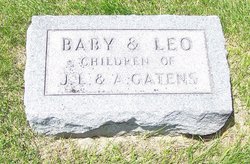
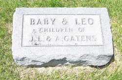
James Leo Gatens
| Birth | : | 23 Nov 1883 Cedar Valley, Cedar County, Iowa, USA |
| Death | : | 4 Oct 1947 Iowa City, Johnson County, Iowa, USA |
| Burial | : | St. Mary's Churchyard, Claverton, Bath and North East Somerset Unitary Authority, England |
| Coordinate | : | 51.3757560, -2.3061500 |
| Description | : | J. L. Gatens, 63, an associate in the Iowa City Sales Co, and former Cedar Valley farmer, died of a heart attack at 3:10 p.m. Saturday [October 4, 1947] at his home at 414 South Lucas Street. Mr. Gatens was born November 23, 1883, and was married to Anna Tucker at Cedar Valley in 1916. The couple lived at a farm home in that community until 1934, when the family moved to Iowa City. Funeral services were held this morning at St. Patrick's church in Iowa City, and burial was in St. Joseph's cemetery at Cedar Valley.... Read More |
frequently asked questions (FAQ):
-
Where is James Leo Gatens's memorial?
James Leo Gatens's memorial is located at: St. Mary's Churchyard, Claverton, Bath and North East Somerset Unitary Authority, England.
-
When did James Leo Gatens death?
James Leo Gatens death on 4 Oct 1947 in Iowa City, Johnson County, Iowa, USA
-
Where are the coordinates of the James Leo Gatens's memorial?
Latitude: 51.3757560
Longitude: -2.3061500
Family Members:
Parent
Spouse
Siblings
Children
Flowers:
Nearby Cemetories:
1. St. Mary's Churchyard
Claverton, Bath and North East Somerset Unitary Authority, England
Coordinate: 51.3757560, -2.3061500
2. Claverton Cemetery
Bath, Bath and North East Somerset Unitary Authority, England
Coordinate: 51.3758190, -2.3060720
3. St. Mary The Virgin Churchyard
Bathwick, Bath and North East Somerset Unitary Authority, England
Coordinate: 51.3759930, -2.3411930
4. St Swithun Churchyard
Bathford, Bath and North East Somerset Unitary Authority, England
Coordinate: 51.3981960, -2.3060840
5. Smallcombe Vale Cemetery
Bathwick, Bath and North East Somerset Unitary Authority, England
Coordinate: 51.3757400, -2.3429400
6. St. Nicholas' Churchyard
Bathampton, Bath and North East Somerset Unitary Authority, England
Coordinate: 51.3974090, -2.3216890
7. St. Michael's Churchyard
Monkton Combe, Bath and North East Somerset Unitary Authority, England
Coordinate: 51.3559540, -2.3285700
8. St Thomas à Becket's Church
Widcombe, Bath and North East Somerset Unitary Authority, England
Coordinate: 51.3734250, -2.3465560
9. Prior Park College
Bath, Bath and North East Somerset Unitary Authority, England
Coordinate: 51.3645990, -2.3442400
10. Bath Abbey Cemetery
Widcombe, Bath and North East Somerset Unitary Authority, England
Coordinate: 51.3712850, -2.3483060
11. Quaker Burial Ground
Batheaston, Bath and North East Somerset Unitary Authority, England
Coordinate: 51.4024970, -2.3100210
12. St John the Evangelist Cemetery
Bath, Bath and North East Somerset Unitary Authority, England
Coordinate: 51.3696700, -2.3487400
13. Quaker Burial Ground
Widcombe, Bath and North East Somerset Unitary Authority, England
Coordinate: 51.3744350, -2.3498460
14. Union Chapel
Combe Down, Bath and North East Somerset Unitary Authority, England
Coordinate: 51.3594751, -2.3443662
15. Old Baptist Burial Ground
Walcot, Bath and North East Somerset Unitary Authority, England
Coordinate: 51.3755070, -2.3544360
16. Abbey & St James' Graveyard for the Poor
Widcombe, Bath and North East Somerset Unitary Authority, England
Coordinate: 51.3753550, -2.3545640
17. Unitarian Chapel Burial Ground
Widcombe, Bath and North East Somerset Unitary Authority, England
Coordinate: 51.3704650, -2.3539270
18. Baptist Burial Ground
Widcombe, Bath and North East Somerset Unitary Authority, England
Coordinate: 51.3764216, -2.3556947
19. St Saviour's Church Crypt
Larkhall, Bath and North East Somerset Unitary Authority, England
Coordinate: 51.3956300, -2.3465100
20. St. Mary's Churchyard
Bathwick, Bath and North East Somerset Unitary Authority, England
Coordinate: 51.3876120, -2.3543540
21. Old Orchard Street Catholic Burial Vault
Bath, Bath and North East Somerset Unitary Authority, England
Coordinate: 51.3800370, -2.3579910
22. Saint Mark's Churchyard
Widcombe, Bath and North East Somerset Unitary Authority, England
Coordinate: 51.3766660, -2.3588010
23. St. John the Baptist Churchyard
Bathwick, Bath and North East Somerset Unitary Authority, England
Coordinate: 51.3886890, -2.3547030
24. Bath Abbey
Bath, Bath and North East Somerset Unitary Authority, England
Coordinate: 51.3815310, -2.3586640

