James Leroy Applegate
| Birth | : | 19 Sep 1852 Pennsylvania, USA |
| Death | : | 28 Apr 1925 Jackson County, Iowa, USA |
| Burial | : | Craig Memorial Cemetery, Old Pickens, Oconee County, USA |
| Coordinate | : | 34.7914848, -82.8876801 |
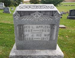
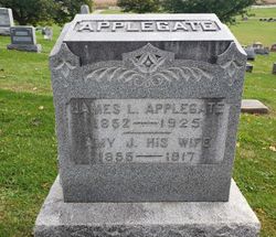
| Description | : | JAMES L APPLEGATE Maquoketa, Iowa - James LeRoy Applegate, a retired Perry Township farmer, died Tuesday morning after several year of failing health. Born in Pennsylvania, Sept 19, 1852, he came west with his parents at the age of two years. His family settling in Perry Township and when the Civil war broke out, his oldest brothers enlisted in the services of their country. James as the youngest of the family, and survived by two brothers, Hayes of South Bend, Ind., and Ham of Maquoketa, both veterans. His wife, who was Amy J Fenton and to whom he was married... Read More |
frequently asked questions (FAQ):
-
Where is James Leroy Applegate's memorial?
James Leroy Applegate's memorial is located at: Craig Memorial Cemetery, Old Pickens, Oconee County, USA.
-
When did James Leroy Applegate death?
James Leroy Applegate death on 28 Apr 1925 in Jackson County, Iowa, USA
-
Where are the coordinates of the James Leroy Applegate's memorial?
Latitude: 34.7914848
Longitude: -82.8876801
Family Members:
Parent
Spouse
Siblings
Children
Flowers:
Nearby Cemetories:
1. Craig Memorial Cemetery
Old Pickens, Oconee County, USA
Coordinate: 34.7914848, -82.8876801
2. Old Pickens Cemetery
Old Pickens, Oconee County, USA
Coordinate: 34.7910995, -82.8867035
3. Little-Jenkins Cemetery
Oconee County, USA
Coordinate: 34.7883730, -82.8916650
4. Powers Family Cemetery
Pickens County, USA
Coordinate: 34.7966500, -82.8755170
5. Morgan Family Cemetery
Central, Pickens County, USA
Coordinate: 34.7825670, -82.8750170
6. Cary Cemetery
Oconee County, USA
Coordinate: 34.7700005, -82.8966980
7. Kings Grove Baptist Church Cemetery
Central, Pickens County, USA
Coordinate: 34.7829000, -82.8574000
8. Old Kings Grove Baptist Church Cemetery
Central, Pickens County, USA
Coordinate: 34.7648330, -82.8737500
9. New Foundation Cemetery
Oconee County, USA
Coordinate: 34.7668991, -82.9077988
10. Robert Morgan-Cannon Family
Central, Pickens County, USA
Coordinate: 34.7820850, -82.8521350
11. High Falls Cemetery
Oconee County, USA
Coordinate: 34.8013992, -82.9310989
12. Gap Hill Baptist Church Cemetery
Six Mile, Pickens County, USA
Coordinate: 34.8293991, -82.8613968
13. Pleasant Hill Baptist Church Cemetery
Central, Pickens County, USA
Coordinate: 34.7633018, -82.8324966
14. Mount Olivet Wesleyan Church Cemetery
Six Mile, Pickens County, USA
Coordinate: 34.8121430, -82.8242680
15. Six Mile Baptist Church Cemetery
Six Mile, Pickens County, USA
Coordinate: 34.8074989, -82.8214035
16. Church of God of Prophecy Cemetery
Six Mile, Pickens County, USA
Coordinate: 34.7962860, -82.8183080
17. Stamp Creek Cemetery
Oconee County, USA
Coordinate: 34.8417015, -82.9250031
18. Hunnicutt Family Cemetery
Salem, Oconee County, USA
Coordinate: 34.8339350, -82.9378370
19. Dodd Family Cemetery
Westminster, Oconee County, USA
Coordinate: 34.7327499, -82.8743134
20. New Hope Cemetery
Seneca, Oconee County, USA
Coordinate: 34.7667007, -82.9543991
21. Stephens Family Cemetery
Pickens, Pickens County, USA
Coordinate: 34.8521060, -82.8735060
22. Lawrence Chapel United Methodist Church Cemetery
Central, Pickens County, USA
Coordinate: 34.7447014, -82.8360977
23. Cedar Hill Holiness Church Cemetery
Six Mile, Pickens County, USA
Coordinate: 34.8324530, -82.8202970
24. Keowee Baptist Church Cemetery
Six Mile, Pickens County, USA
Coordinate: 34.8613830, -82.8759000


