
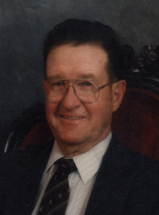
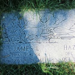
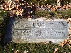
James Lester “Jim” Reid
| Birth | : | 15 May 1914 Alturas, Modoc County, California, USA |
| Death | : | 8 Nov 2004 Alturas, Modoc County, California, USA |
| Burial | : | Maple Lawn Cemetery, Flora, Carroll County, USA |
| Coordinate | : | 40.5468750, -86.5001678 |
| Plot | : | James Lester Reid |
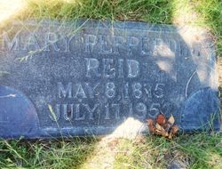
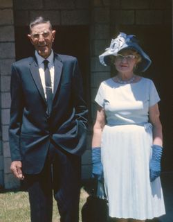
| Description | : | James Lester Reid May 15, 1914 – November 8, 2004 Services to celebrate the life of James Lester Reid were held in Alturas on November 10, 2004, with the Reverend Dr. Ben Zandstra of the Federated Community Church officiating. Burial was in the Alturas Cemetery. A potluck luncheon for family and friends was held in honor of Jim and his wife Hazel, who passed away nine days before him, at the Arrowhead Golf Course clubhouse after the services. Jim was born on May 15, 1914, on Parker Creek in Alturas, California, to David Graham Reid and Mary Porter Pepperdine Reid. His father was... Read More |
frequently asked questions (FAQ):
-
Where is James Lester “Jim” Reid's memorial?
James Lester “Jim” Reid's memorial is located at: Maple Lawn Cemetery, Flora, Carroll County, USA.
-
When did James Lester “Jim” Reid death?
James Lester “Jim” Reid death on 8 Nov 2004 in Alturas, Modoc County, California, USA
-
Where are the coordinates of the James Lester “Jim” Reid's memorial?
Latitude: 40.5468750
Longitude: -86.5001678
Family Members:
Parent
Spouse

Siblings
Children

Flowers:


Nearby Cemetories:
1. Maple Lawn Cemetery
Flora, Carroll County, USA
Coordinate: 40.5468750, -86.5001678
2. Shirar - Landis Cemetery
Flora, Carroll County, USA
Coordinate: 40.5457497, -86.4904022
3. Moss Cemetery
Flora, Carroll County, USA
Coordinate: 40.5395546, -86.5036697
4. Old Flora Cemetery
Flora, Carroll County, USA
Coordinate: 40.5523600, -86.5204800
5. Monroe Township Unidentified Cemetery
Monroe Township, Carroll County, USA
Coordinate: 40.5286550, -86.5170840
6. Cline Family Cemetery
Flora, Carroll County, USA
Coordinate: 40.5177383, -86.4634552
7. McCain Graveyard
Carrollton Township, Carroll County, USA
Coordinate: 40.5704200, -86.4509300
8. Musselman Cemetery
Camden, Carroll County, USA
Coordinate: 40.5914001, -86.5018997
9. Old Brethren Church Cemetery
Camden, Carroll County, USA
Coordinate: 40.5832040, -86.5492890
10. Knettle Cemetery
Camden, Carroll County, USA
Coordinate: 40.5780678, -86.5590591
11. Cutler Ridge Congregation Church Cemetery
Flora, Carroll County, USA
Coordinate: 40.4960210, -86.5288860
12. Milburn Cemetery
Burlington Township, Carroll County, USA
Coordinate: 40.4877010, -86.4671320
13. Paint Creek Cemetery
Camden, Carroll County, USA
Coordinate: 40.6122818, -86.4960480
14. Burlington Township Unidentified Cemetery
Burlington Township, Carroll County, USA
Coordinate: 40.4915380, -86.4537230
15. Asbury Cemetery
Burlington, Carroll County, USA
Coordinate: 40.4914017, -86.4492035
16. Camden Cemetery
Camden, Carroll County, USA
Coordinate: 40.6068268, -86.5434723
17. Carnell Cemetery
Carrollton Township, Carroll County, USA
Coordinate: 40.5996000, -86.4418000
18. Snoeberger Cemetery
Carroll County, USA
Coordinate: 40.6035995, -86.5623016
19. Zion Citizens Cemetery
Bringhurst, Carroll County, USA
Coordinate: 40.5256004, -86.5932999
20. Arthur Cemetery
Burlington Township, Carroll County, USA
Coordinate: 40.4957000, -86.4285000
21. Ball Hill Cemetery
Cutler, Carroll County, USA
Coordinate: 40.4675522, -86.4771576
22. Nebo Cemetery
Camden, Carroll County, USA
Coordinate: 40.6043663, -86.5770416
23. Wise Cemetery
Camden, Carroll County, USA
Coordinate: 40.6048393, -86.5797119
24. Beech Grove Cemetery
Sharon, Carroll County, USA
Coordinate: 40.5545540, -86.3899307