
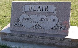
James Lester “Pete” Blair
| Birth | : | 18 May 1920 Yetter, Calhoun County, Iowa, USA |
| Death | : | 17 Dec 2004 Fonda, Pocahontas County, Iowa, USA |
| Burial | : | Lake City Cemetery, Lake City, Calhoun County, USA |
| Coordinate | : | 42.2719002, -94.7574997 |
| Inscription | : | Parents of James, Kenneth, Danny, Beverly, Paul, Bradley |
| Description | : | James Lester Blair, age 84, of Fonda, Iowa, died Friday, December 17, 2004 at his home surrounded by his loved ones. Jim was born May 18, 1920 on a farm near Yetter, Iowa. He attended country school and graduated from Auborn High School in 1937. He was united in marriage to Edythe Beatrice Hines on June 15, 1941. Jim farmed until 1950, then moved his family to Michigan, retiring from General Motors in 1981. He and Edythe moved back to Yetter after his retirement and then in 1995 returned to Fonda. He was a member of the United Church of... Read More |
frequently asked questions (FAQ):
-
Where is James Lester “Pete” Blair's memorial?
James Lester “Pete” Blair's memorial is located at: Lake City Cemetery, Lake City, Calhoun County, USA.
-
When did James Lester “Pete” Blair death?
James Lester “Pete” Blair death on 17 Dec 2004 in Fonda, Pocahontas County, Iowa, USA
-
Where are the coordinates of the James Lester “Pete” Blair's memorial?
Latitude: 42.2719002
Longitude: -94.7574997
Family Members:
Parent

Siblings

Children

Flowers:


Nearby Cemetories:
1. Lake City Cemetery
Lake City, Calhoun County, USA
Coordinate: 42.2719002, -94.7574997
2. Saint Marys Catholic Cemetery
Lake City, Calhoun County, USA
Coordinate: 42.2730000, -94.7567000
3. Cottonwood Cemetery
Lake City, Calhoun County, USA
Coordinate: 42.2491989, -94.7936020
4. Saint Marys Cemetery
Sac County, USA
Coordinate: 42.2611008, -94.8839035
5. Lanesboro Cemetery
Lanesboro, Carroll County, USA
Coordinate: 42.1810989, -94.7230988
6. Oak Lawn Cemetery
Auburn, Sac County, USA
Coordinate: 42.2611008, -94.8852997
7. Bishop Cemetery
Calhoun Township, Calhoun County, USA
Coordinate: 42.2230400, -94.6453190
8. Lake Creek Cemetery
Calhoun County, USA
Coordinate: 42.3394012, -94.6631012
9. Grant City Cemetery
Grant City, Sac County, USA
Coordinate: 42.2681007, -94.8908005
10. East Liberty Cemetery
Lidderdale, Carroll County, USA
Coordinate: 42.1591988, -94.7636032
11. Saint Peters Lutheran Cemetery
Sac County, USA
Coordinate: 42.3543000, -94.8868000
12. Lutheran Emanuel Cemetery
Coon Valley Township, Sac County, USA
Coordinate: 42.3692017, -94.8771973
13. Luckow Cemetery
Auburn, Sac County, USA
Coordinate: 42.2168999, -94.9266968
14. Immanuel Cemetery
Lidderdale, Carroll County, USA
Coordinate: 42.1389008, -94.8022003
15. Holy Family Cemetery
Lidderdale, Carroll County, USA
Coordinate: 42.1178017, -94.7839966
16. Garfield Cemetery
Calhoun County, USA
Coordinate: 42.4275017, -94.7902985
17. North Coon Cemetery
Carroll County, USA
Coordinate: 42.1260986, -94.6716995
18. Our Lady Of Mount Carmel Cemetery
Mount Carmel, Carroll County, USA
Coordinate: 42.1547012, -94.9088974
19. Evergreen Cemetery
Lohrville, Calhoun County, USA
Coordinate: 42.2505989, -94.5330963
20. Reformatory Cemetery
Rockwell City, Calhoun County, USA
Coordinate: 42.3952570, -94.6038660
21. Rosehill Cemetery
Rockwell City, Calhoun County, USA
Coordinate: 42.4042015, -94.6128006
22. Dickson Cemetery
Glidden Township, Carroll County, USA
Coordinate: 42.1074982, -94.6939011
23. Saint Francis Cemetery
Rockwell City, Calhoun County, USA
Coordinate: 42.4055000, -94.6127000
24. Twin Lakes Cemetery
Jolley, Calhoun County, USA
Coordinate: 42.4427986, -94.6889038