
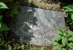
| Birth | : | 19 Sep 1833 Carsphairn, Dumfries and Galloway, Scotland |
| Death | : | 18 Jan 1911 Gordon, Manitoulin District, Ontario, Canada |
| Burial | : | Gordon Cemetery, Gordon, Manitoulin District, Canada |
| Coordinate | : | 45.8757300, -82.4724300 |
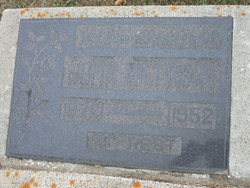
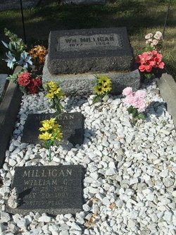
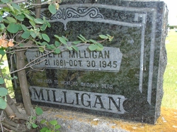
| Description | : | Concession 09, Lot 21, Mickie Hinds (North part - 100 acres); Lyle & Heather Strain (South part - 30 Acres); Scot and Susan Strain (house & 2 Acres). In 1880 this land was registered from the crown, by James and Annie (McPherson) Milligan who had arrived from Durham the previous year. They had quite a large family, with some of them likely born before they came. There was Wallace who later married Ester Best from down the road, and bought the farm next door (the Bert Best place) in 1905 and lived there for approximately 15 years... Read More |
frequently asked questions (FAQ):
-
Where is James Milligan's memorial?
James Milligan's memorial is located at: Gordon Cemetery, Gordon, Manitoulin District, Canada.
-
When did James Milligan death?
James Milligan death on 18 Jan 1911 in Gordon, Manitoulin District, Ontario, Canada
-
Where are the coordinates of the James Milligan's memorial?
Latitude: 45.8757300
Longitude: -82.4724300
Family Members:
Spouse

Children
Flowers:


Nearby Cemetories:
1. Gordon Cemetery
Gordon, Manitoulin District, Canada
Coordinate: 45.8757300, -82.4724300
2. Long Bay Cemetery
Long Bay, Manitoulin District, Canada
Coordinate: 45.8056680, -82.3795380
3. Burpee Mills Cemetery
Burpee and Mills, Manitoulin District, Canada
Coordinate: 45.7685100, -82.5328800
4. Kagawong Cedars Cemetery
Kagawong, Manitoulin District, Canada
Coordinate: 45.9089600, -82.2568300
5. Grimesthorpe Cemetery
Grimsthorpe, Manitoulin District, Canada
Coordinate: 45.7098120, -82.3246620
6. M'Chigeeng Cemetery
West Bay, Manitoulin District, Canada
Coordinate: 45.8163400, -82.1601200
7. Mindemoya Cemetery
Mindemoya, Manitoulin District, Canada
Coordinate: 45.7473100, -82.1928000
8. Providence Bay Cemetery
Providence Bay, Manitoulin District, Canada
Coordinate: 45.6728600, -82.2664600
9. Cold Springs Cemetery
Cold Springs, Manitoulin District, Canada
Coordinate: 45.8595060, -82.1087820
10. Sheshegwaning Catholic Cemetery
Sheshegwaning, Manitoulin District, Canada
Coordinate: 45.9369839, -82.8383913
11. Silver Lake Cemetery
Silver Water, Manitoulin District, Canada
Coordinate: 45.8578000, -82.8552000
12. Sheshegwaning Anglican Cemetery
Sheshegwaning, Manitoulin District, Canada
Coordinate: 45.9368920, -82.8522804
13. Green Bay United Church Cemetery
Manitoulin, Manitoulin District, Canada
Coordinate: 45.8603520, -82.0223110
14. Big Lake Cemetery
Manitoulin, Manitoulin District, Canada
Coordinate: 45.7457500, -82.0575900
15. Mount Calvary Cemetery
Spanish, Algoma District, Canada
Coordinate: 46.1906000, -82.3556000
16. Serpent River First Nations Cemetery
Serpent River, Algoma District, Canada
Coordinate: 46.2049600, -82.4753500
17. Sucker Creek Cemetery
Sucker Creek, Manitoulin District, Canada
Coordinate: 45.9604060, -81.9764140
18. Walford Catholic Cemetery
Walford, Sudbury District, Canada
Coordinate: 46.2051610, -82.2496750
19. Walford Protestant Cemetery
Walford, Sudbury District, Canada
Coordinate: 46.2055010, -82.2495430
20. St. Bernard's Catholic Cemetery
Little Current, Manitoulin District, Canada
Coordinate: 45.9789170, -81.9596700
21. Mountain View Cemetery
Little Current, Manitoulin District, Canada
Coordinate: 45.9604400, -81.9523100
22. Holy Trinity Anglican Cemetery
Little Current, Manitoulin District, Canada
Coordinate: 45.9677590, -81.9439240
23. Old River Road Cemetery
Massey, Sudbury District, Canada
Coordinate: 46.1742260, -82.1342000
24. Sagamok New Cemetery
Sagamok, Algoma District, Canada
Coordinate: 46.1582040, -82.1007238