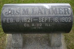
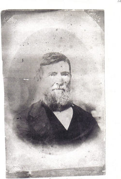
James Monroe Latimer
| Birth | : | 6 Feb 1821 Montville, New London County, Connecticut, USA |
| Death | : | 16 Sep 1902 Churdan, Greene County, Iowa, USA |
| Burial | : | Highland Township Cemetery, Churdan, Greene County, USA |
| Coordinate | : | 42.1518310, -94.4699120 |
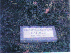
| Description | : | GAR marker. James Monroe Latimer, F.A.G. #37453411, was the son of Lynde Lord and Thankful Matilda (chapman) Dunn. He was married to Amanda L. Sutton on June 15 1853 in Kosciusko County IN. James and Amanda had four children: Nancy A., John S., Hannah M. and Mary. They owned a farm near Fairbury, Jefferson County, NE. After the death of his wife, Mr. Latimer moved to Churdan, Greene County, IA to be near his daughter, Nancy (Latimer) Coatney. Civil War Veteran James M Latimer Residence: Enlistment Date: 12 Aug 1862 Rank at enlistment: Corporal State Served: Illinois |
frequently asked questions (FAQ):
-
Where is James Monroe Latimer's memorial?
James Monroe Latimer's memorial is located at: Highland Township Cemetery, Churdan, Greene County, USA.
-
When did James Monroe Latimer death?
James Monroe Latimer death on 16 Sep 1902 in Churdan, Greene County, Iowa, USA
-
Where are the coordinates of the James Monroe Latimer's memorial?
Latitude: 42.1518310
Longitude: -94.4699120
Family Members:
Parent
Siblings
Flowers:
Nearby Cemetories:
1. Highland Township Cemetery
Churdan, Greene County, USA
Coordinate: 42.1518310, -94.4699120
2. Saint Patricks Cemetery
Churdan, Greene County, USA
Coordinate: 42.1605988, -94.5511017
3. Old Cedar Cemetery
Adaza, Greene County, USA
Coordinate: 42.1874821, -94.5419194
4. Dawson Cemetery
Paton, Greene County, USA
Coordinate: 42.1655998, -94.3283005
5. Evergreen Cemetery
Lohrville, Calhoun County, USA
Coordinate: 42.2505989, -94.5330963
6. Saint Joseph Cemetery
Lohrville, Calhoun County, USA
Coordinate: 42.2569008, -94.5119019
7. Gibson-Fleck-Thompson Cemetery
Scranton, Greene County, USA
Coordinate: 42.0428870, -94.4988800
8. Reading Cemetery
Farnhamville, Calhoun County, USA
Coordinate: 42.2593994, -94.4325027
9. Fair Oaks Cemetery
Scranton, Greene County, USA
Coordinate: 42.0355988, -94.4460983
10. Dillavou Cemetery
Kendrick Township, Greene County, USA
Coordinate: 42.0802994, -94.6138992
11. Wright Cemetery
Jefferson, Greene County, USA
Coordinate: 42.0228004, -94.4477997
12. Saint Joseph Cemetery
Jefferson, Greene County, USA
Coordinate: 42.0289001, -94.3818970
13. Scranton Township Cemetery
Scranton, Greene County, USA
Coordinate: 42.0306015, -94.5783005
14. Bishop Cemetery
Calhoun Township, Calhoun County, USA
Coordinate: 42.2230400, -94.6453190
15. Headley Cemetery
Jefferson, Greene County, USA
Coordinate: 42.0041504, -94.4335815
16. North Coon Cemetery
Carroll County, USA
Coordinate: 42.1260986, -94.6716995
17. Jefferson Cemetery
Jefferson, Greene County, USA
Coordinate: 42.0133018, -94.3591995
18. Paton Cemetery
Paton, Greene County, USA
Coordinate: 42.1624985, -94.2433014
19. Dickson Cemetery
Glidden Township, Carroll County, USA
Coordinate: 42.1074982, -94.6939011
20. Gowrie Township Cemetery
Gowrie, Webster County, USA
Coordinate: 42.2813988, -94.3043976
21. Lanesboro Cemetery
Lanesboro, Carroll County, USA
Coordinate: 42.1810989, -94.7230988
22. Cedar Cemetery
Rinard, Calhoun County, USA
Coordinate: 42.3456001, -94.4644012
23. Junction Township Cemetery
Grand Junction, Greene County, USA
Coordinate: 42.0236015, -94.2593994
24. Lost Grove Cemetery
Harcourt, Webster County, USA
Coordinate: 42.2583008, -94.2331009


