

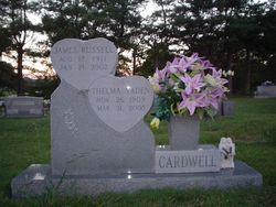

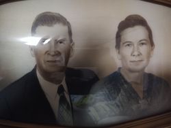
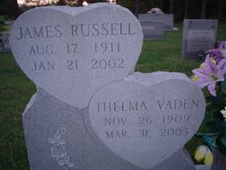
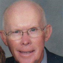
James Russell Reid Cardwell
| Birth | : | 17 Aug 1911 |
| Death | : | 21 Jan 2002 |
| Burial | : | Greenwood Cemetery, Brantford, Brant County Municipality, Canada |
| Coordinate | : | 43.1474838, -80.2625198 |
| Description | : | MAYODAN Mr. James Russell Reid Cardwell, 90, of 562 NC Hwy 770, Mayodan, passed away Monday, Jan. 21, 2002, at his home following a brief illness. His funeral service will be held at 2 p.m. Thursday, Jan. 24, 2002, at Ayersville Baptist Church, with the Rev. Dale Martin and the Rev. Clay Burgess officiating. Interment will follow in the church cemetery. Mr. Cardwell was born August 17, 1911, in Rockingham County, Ayersville Community, a son of the late John David "Nick" Cardwell and the late Lillie Gann Cardwell. He was a retired farmer and general contractor and co-owner - operator of Cardwells... Read More |
frequently asked questions (FAQ):
-
Where is James Russell Reid Cardwell's memorial?
James Russell Reid Cardwell's memorial is located at: Greenwood Cemetery, Brantford, Brant County Municipality, Canada.
-
When did James Russell Reid Cardwell death?
James Russell Reid Cardwell death on 21 Jan 2002 in
-
Where are the coordinates of the James Russell Reid Cardwell's memorial?
Latitude: 43.1474838
Longitude: -80.2625198
Family Members:
Parent

Spouse
Siblings


Children
Flowers:


Nearby Cemetories:
1. Greenwood Cemetery
Brantford, Brant County Municipality, Canada
Coordinate: 43.1474838, -80.2625198
2. Grace Anglican Cemetery
Brantford, Brant County Municipality, Canada
Coordinate: 43.1420521, -80.2700348
3. Mount Hope Cemetery
Brantford, Brant County Municipality, Canada
Coordinate: 43.1600533, -80.2595901
4. Saint Joseph Catholic Cemetery
Brantford, Brant County Municipality, Canada
Coordinate: 43.1582770, -80.2730250
5. Beth David Jewish Cemetery
Brantford, Brant County Municipality, Canada
Coordinate: 43.1610300, -80.2575400
6. Mohawk Chapel Cemetery
Brantford, Brant County Municipality, Canada
Coordinate: 43.1244500, -80.2352500
7. Farringdon Burial Ground
Brantford, Brant County Municipality, Canada
Coordinate: 43.1160370, -80.2780280
8. Oakhill Cemetery
Brantford, Brant County Municipality, Canada
Coordinate: 43.1345901, -80.3077164
9. Tranquility Cemetery
Brantford, Brant County Municipality, Canada
Coordinate: 43.1848742, -80.2819573
10. Johnson Cemetery
Brantford, Brant County Municipality, Canada
Coordinate: 43.1670000, -80.1877000
11. Westbrook Cemetery
Cainsville, Brant County Municipality, Canada
Coordinate: 43.1472000, -80.1806000
12. Salt Springs Church Cemetery
Brantford, Brant County Municipality, Canada
Coordinate: 43.0992600, -80.2132400
13. Brant Cemetery
Cainsville, Brant County Municipality, Canada
Coordinate: 43.1520700, -80.1752400
14. Brant-St. Mary's Cemetery
Brantford, Brant County Municipality, Canada
Coordinate: 43.1523340, -80.1747250
15. Fonger Cemetery
South Dumfries, Brant County Municipality, Canada
Coordinate: 43.1829000, -80.1830000
16. Holy Cross Cemetery
Paris, Brant County Municipality, Canada
Coordinate: 43.1969200, -80.3287400
17. All Saints Anglican Church Cemetery
Mount Pleasant, Brant County Municipality, Canada
Coordinate: 43.0791300, -80.3123800
18. Bethel Church Cemetery
Ancaster, Hamilton Municipality, Canada
Coordinate: 43.2106018, -80.2001038
19. Mason Deagle Cemetery
Onondaga, Brant County Municipality, Canada
Coordinate: 43.1258000, -80.1585000
20. Clump Cemetery
South Dumfries, Brant County Municipality, Canada
Coordinate: 43.2199700, -80.3072200
21. Papple Cemetery
Brant County Municipality, Canada
Coordinate: 43.2175941, -80.2111359
22. Mount Pleasant Cemetery
Mount Pleasant, Brant County Municipality, Canada
Coordinate: 43.0772700, -80.3137000
23. Grand River United Church Cemetery
Six Nations, Brant County Municipality, Canada
Coordinate: 43.0870440, -80.1757051
24. Tapley Cemetery
Burford, Brant County Municipality, Canada
Coordinate: 43.1045400, -80.3693200