

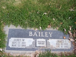
Janet Wanda Dunkin Bailey
| Birth | : | 27 Sep 1927 Unionville, Putnam County, Missouri, USA |
| Death | : | 22 Mar 1993 Quincy, Grant County, Washington, USA |
| Burial | : | Six Mile Cemetery, Indian Land, Lancaster County, USA |
| Coordinate | : | 34.9308014, -80.8319016 |
| Description | : | Janet was born to Charles and Amel (Skipper) Dunkin. Her family moved to Cashmere in 1943. Janet married James Bailey on June 11, 1948 in Cashmere. janet is survived by Her husband and daughter Carol Bailey of Yakima and her parents Charles and Amel Dunkin of Wenatchee. |
frequently asked questions (FAQ):
-
Where is Janet Wanda Dunkin Bailey's memorial?
Janet Wanda Dunkin Bailey's memorial is located at: Six Mile Cemetery, Indian Land, Lancaster County, USA.
-
When did Janet Wanda Dunkin Bailey death?
Janet Wanda Dunkin Bailey death on 22 Mar 1993 in Quincy, Grant County, Washington, USA
-
Where are the coordinates of the Janet Wanda Dunkin Bailey's memorial?
Latitude: 34.9308014
Longitude: -80.8319016
Family Members:
Parent

Spouse
Siblings

Flowers:


Nearby Cemetories:
1. Six Mile Cemetery
Indian Land, Lancaster County, USA
Coordinate: 34.9308014, -80.8319016
2. Indian Land Baptist Church Cemetery
Indian Land, Lancaster County, USA
Coordinate: 34.9318840, -80.8367260
3. Center Grove Memorial Park
Indian Land, Lancaster County, USA
Coordinate: 34.9205500, -80.8122100
4. Old Six Mile Cemetery
Indian Land, Lancaster County, USA
Coordinate: 34.9484250, -80.8220320
5. Belair Methodist Church Cemetery
Lancaster County, USA
Coordinate: 34.9509964, -80.8433228
6. Gold Hill AME Zion Church Cemetery
Van Wyck, Lancaster County, USA
Coordinate: 34.9094340, -80.8472940
7. Osceola United Methodist Church Cemetery
Lancaster, Lancaster County, USA
Coordinate: 34.9056920, -80.8091770
8. Elbethel AME Zion Church Cemetery
Belair, Lancaster County, USA
Coordinate: 34.9626270, -80.8299860
9. Our Lady of Grace Catholic Church Cemetery
Indian Land, Lancaster County, USA
Coordinate: 34.9191510, -80.7933580
10. Old Elbethel AME Zion Church Cemetery
Indian Land, Lancaster County, USA
Coordinate: 34.9631250, -80.8125350
11. Macedonia Baptist Church
Indian Land, Lancaster County, USA
Coordinate: 34.8975580, -80.8555820
12. Higher Ground Church Cemetery
Indian Land, Lancaster County, USA
Coordinate: 34.9713300, -80.8597020
13. Catawba Indian Nation Cemetery
Rock Hill, York County, USA
Coordinate: 34.9043999, -80.8824005
14. Steele Hill AME Zion Church Cemetery
Lancaster, Lancaster County, USA
Coordinate: 34.8898697, -80.7984009
15. Edwards Cemetery
Indian Land, Lancaster County, USA
Coordinate: 34.9770010, -80.8607570
16. Heath Memorial United Methodist Church Cemetery
Union County, USA
Coordinate: 34.8889046, -80.7834396
17. Price Chapel Baptist Church Cemetery
Waxhaw, Union County, USA
Coordinate: 34.9415283, -80.7617188
18. Church of Jesus Christ of Latter-day Sts Cemetery
Catawba, York County, USA
Coordinate: 34.9071007, -80.9012985
19. Banks Presbyterian Church Cemetery
Marvin, Union County, USA
Coordinate: 34.9930305, -80.8189697
20. Marvin United Methodist Church Cemetery
Marvin, Union County, USA
Coordinate: 34.9928894, -80.8166580
21. Pleasant Valley Baptist Church Cemetery
Lancaster County, USA
Coordinate: 34.9931793, -80.8495407
22. Providence Baptist Church Cemetery
Waxhaw, Union County, USA
Coordinate: 34.9441200, -80.7547200
23. Marvin AME Zion Church Cemetery
Waxhaw, Union County, USA
Coordinate: 34.9920000, -80.8040000
24. Bonds Grove United Methodist Church Cemetery
Waxhaw, Union County, USA
Coordinate: 34.9739609, -80.7715378