
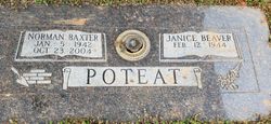
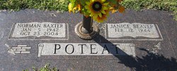
Janice Ruth Beaver Poteat
| Birth | : | 12 Feb 1944 Iredell County, North Carolina, USA |
| Death | : | 6 Mar 2019 Mooresville, Iredell County, North Carolina, USA |
| Burial | : | Saint Lukes Evangelical Lutheran Church Cemetery, Mount Ulla, Rowan County, USA |
| Coordinate | : | 35.6810800, -80.6849760 |
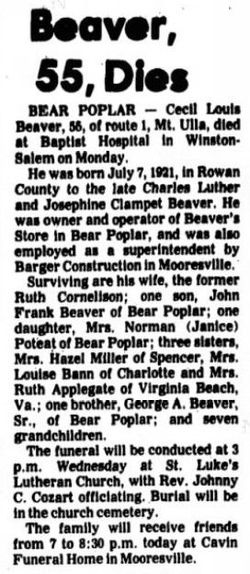
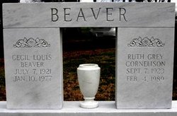
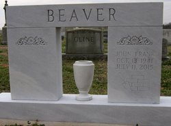
| Description | : | Janice Ruth Beaver Poteat, 75, of Mt. Ulla, went home to be with her Lord on Wednesday, March 6, 2019 at Serenity House in Mooresville. Born in Iredell County on February 12, 1944, she was the daughter of the late Cecil Louis Beaver and Ruth Cornelius Beaver. Janice worked as a church secretary and retired from Cleveland First Baptist Church after more than 20 years of faithful service. She enjoyed gardening, canning vegetables and working puzzles. Most of all, she enjoyed being a wife, mother, grandmother, and great-grandmother. Janice was a member of St. Luke’s Lutheran... Read More |
frequently asked questions (FAQ):
-
Where is Janice Ruth Beaver Poteat's memorial?
Janice Ruth Beaver Poteat's memorial is located at: Saint Lukes Evangelical Lutheran Church Cemetery, Mount Ulla, Rowan County, USA.
-
When did Janice Ruth Beaver Poteat death?
Janice Ruth Beaver Poteat death on 6 Mar 2019 in Mooresville, Iredell County, North Carolina, USA
-
Where are the coordinates of the Janice Ruth Beaver Poteat's memorial?
Latitude: 35.6810800
Longitude: -80.6849760
Family Members:
Parent
Spouse
Siblings
Children

Flowers:


Nearby Cemetories:
1. Oakland Presbyterian Church USA
Mount Ulla Township, Rowan County, USA
Coordinate: 35.6549000, -80.6785000
2. Ebenezer Methodist Church Cemetery
Mount Ulla, Rowan County, USA
Coordinate: 35.6930200, -80.6425900
3. Mount Zion Baptist Church
Mount Ulla, Rowan County, USA
Coordinate: 35.6712060, -80.6366480
4. Back Creek Presbyterian Church Cemetery
Mount Ulla, Rowan County, USA
Coordinate: 35.6415901, -80.6991501
5. Cleveland Memorial Garden
Cleveland, Rowan County, USA
Coordinate: 35.7276640, -80.6863050
6. Thyatira Presbyterian Church Cemetery
Mill Bridge, Rowan County, USA
Coordinate: 35.6506310, -80.6371002
7. Mount Tabor Presbyterian Church Cemetery
Cleveland, Rowan County, USA
Coordinate: 35.6826700, -80.7501100
8. Cleveland First Baptist Church Cemetery
Cleveland, Rowan County, USA
Coordinate: 35.7347650, -80.6802790
9. Christ Episcopal Church Cemetery
Cleveland, Rowan County, USA
Coordinate: 35.7333000, -80.6653380
10. Cleveland Town Cemetery
Cleveland, Rowan County, USA
Coordinate: 35.7357660, -80.6806540
11. Allen Temple Presbyterian Church Cemetery
Cleveland, Rowan County, USA
Coordinate: 35.7343320, -80.6684760
12. Knox Chapel United Methodist Church
Cleveland, Rowan County, USA
Coordinate: 35.7081200, -80.7457400
13. Sills Creek AME Zion Church Cemetery
Mount Ulla, Rowan County, USA
Coordinate: 35.6209000, -80.7099000
14. Cedar Grove AME Zion Church Cemetery
Rowan County, USA
Coordinate: 35.7240520, -80.6270450
15. Centenary Methodist Church Cemetery
Mount Ulla, Rowan County, USA
Coordinate: 35.6272202, -80.7414398
16. Sherrills Ford Road Church Cemetery
Salisbury, Rowan County, USA
Coordinate: 35.6884308, -80.5954590
17. Lebanon Lutheran Church Cemetery
Cleveland, Rowan County, USA
Coordinate: 35.7402300, -80.6266800
18. Knox Grove Baptist Church
Cleveland, Rowan County, USA
Coordinate: 35.7557070, -80.7115100
19. Third Creek Presbyterian Church Cemetery
Cleveland, Rowan County, USA
Coordinate: 35.7607420, -80.6841160
20. Antioch Baptist Church Cemetery
Iredell County, USA
Coordinate: 35.7072400, -80.7780450
21. Antioch Baptist Church Cemetery
Cleveland, Rowan County, USA
Coordinate: 35.7074203, -80.7789536
22. Amity Evangelical Lutheran Cemetery
Iredell County, USA
Coordinate: 35.6990140, -80.7847230
23. House of Prayer of Faith Cemetery
Cleveland, Rowan County, USA
Coordinate: 35.7132900, -80.7851700
24. Saint Marks Lutheran Church Cemetery
Salisbury, Rowan County, USA
Coordinate: 35.6541670, -80.5822220