
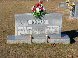
Janie Nathalee Morrow Bogan
| Birth | : | 4 Oct 1923 Buffalo, Union County, South Carolina, USA |
| Death | : | 10 May 2005 Spartanburg County, South Carolina, USA |
| Burial | : | Bohemian Cemetery, Omaha, Douglas County, USA |
| Coordinate | : | 41.2388992, -95.9955978 |
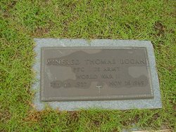
| Description | : | Janie Nathalee (Morrow) Bogan, 81, of Jonesville, SC, widow of Winfred Thomas "W.T." Bogan, died Tuesday, May 10, 2005 at 8:59 p.m. in Spartanburg Regional Medical Center. Born in Buffalo, SC, on October 4, 1923, a daughter of the late James Aaron Morrow and Zala (Massey) Morrow. Member of Bogansville United Methodist Church and the former original owner of Bogans Party Shop, Main Street, Jonesville. Surviving are a daughter, Monica Bogan Price and husband Arnold of Jonesville; a son, Monty Joe Bogan, Sr. of Jonesville; a sister, Rachel M. Crawford of Union; three grandchildren, Damita Bogan DeDe Frost and husband Gary, Haley... Read More |
frequently asked questions (FAQ):
-
Where is Janie Nathalee Morrow Bogan's memorial?
Janie Nathalee Morrow Bogan's memorial is located at: Bohemian Cemetery, Omaha, Douglas County, USA.
-
When did Janie Nathalee Morrow Bogan death?
Janie Nathalee Morrow Bogan death on 10 May 2005 in Spartanburg County, South Carolina, USA
-
Where are the coordinates of the Janie Nathalee Morrow Bogan's memorial?
Latitude: 41.2388992
Longitude: -95.9955978
Family Members:
Parent

Spouse
Siblings
Children

Flowers:


Nearby Cemetories:
1. Bohemian Cemetery
Omaha, Douglas County, USA
Coordinate: 41.2388992, -95.9955978
2. Westlawn-Hillcrest Memorial Park
Omaha, Douglas County, USA
Coordinate: 41.2346992, -95.9966965
3. Ak-Sar-Ben Racetrack Grounds
Omaha, Douglas County, USA
Coordinate: 41.2414703, -96.0159607
4. Holy Sepulchre Cemetery
Omaha, Douglas County, USA
Coordinate: 41.2543983, -95.9875031
5. Douglas County Poor Farm Cemetery
Omaha, Douglas County, USA
Coordinate: 41.2437240, -95.9723480
6. Calvary Cemetery
Omaha, Douglas County, USA
Coordinate: 41.2364006, -96.0294037
7. First Central Congregational Columbarium
Omaha, Douglas County, USA
Coordinate: 41.2563456, -95.9658365
8. Evergreen Memorial Park Cemetery
Omaha, Douglas County, USA
Coordinate: 41.2393990, -96.0355988
9. Graceland Park Cemetery
Omaha, Douglas County, USA
Coordinate: 41.2113991, -95.9785995
10. Resurrection Cemetery
Omaha, Douglas County, USA
Coordinate: 41.2344208, -96.0365448
11. Nash Chapel Crypt
Omaha, Douglas County, USA
Coordinate: 41.2665090, -95.9721790
12. Saint Mary Magdalene Cemetery
Omaha, Douglas County, USA
Coordinate: 41.2039420, -95.9850610
13. Saint Andrews Episcopal Church Columbarium
Omaha, Douglas County, USA
Coordinate: 41.2492500, -96.0427500
14. Saint Mary's Cemetery
Omaha, Douglas County, USA
Coordinate: 41.2042007, -95.9646988
15. Countryside Community Church Columbarium
Omaha, Douglas County, USA
Coordinate: 41.2483660, -96.0500270
16. Beth El Cemetery
Ralston, Douglas County, USA
Coordinate: 41.2117004, -96.0428009
17. Trinity Cathedral Columbarium
Omaha, Douglas County, USA
Coordinate: 41.2603900, -95.9393660
18. Prospect Hill Cemetery
Omaha, Douglas County, USA
Coordinate: 41.2780991, -95.9593964
19. Saint Johns Cemetery
Bellevue, Sarpy County, USA
Coordinate: 41.1864014, -95.9682999
20. All Saints Episcopal Church Columbarium
Omaha, Douglas County, USA
Coordinate: 41.2785000, -96.0579000
21. Laurel Hill Cemetery
Omaha, Douglas County, USA
Coordinate: 41.1918983, -95.9417038
22. Servants of Mary Cemetery
Omaha, Douglas County, USA
Coordinate: 41.3017170, -96.0258260
23. Fisher Farm Cemetery
Bellevue, Sarpy County, USA
Coordinate: 41.1727982, -95.9760971
24. Hrabik Cemetery
Bellevue, Sarpy County, USA
Coordinate: 41.1726540, -95.9768200