
| Birth | : | 5 Feb 1917 Buck Creek, Delaware County, Iowa, USA |
| Death | : | 5 Feb 2007 Mechanicsville, Cedar County, Iowa, USA |
| Burial | : | Goulburn General Cemetery, Goulburn, Goulburn Mulwaree Council, Australia |
| Coordinate | : | -34.7442800, 149.7541200 |
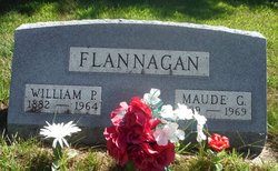
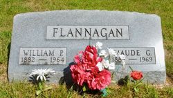
| Description | : | *** IN LOVING MEMORY OF *** Jay Judson Flannagan was born on Monday; February 5, 1917 in the Buck Creek; Delaware County, Iowa area. He was the son of W.P. and Maud Moulton, Flannagan. Jay graduated from the Buck Creek High School in 1935. He then started farming. Jay J. Flannagan and Winona Miles were married on Wednesday; December 14, 1938 at the Buck Creek Methodist Parsonage. The couple farmed in Union Township for several years. In 1949 they moved to their farm near Buck Creek. In 1976 the couple moved to Hopkinton.... Read More |
frequently asked questions (FAQ):
-
Where is Jay Judson Flannagan's memorial?
Jay Judson Flannagan's memorial is located at: Goulburn General Cemetery, Goulburn, Goulburn Mulwaree Council, Australia.
-
When did Jay Judson Flannagan death?
Jay Judson Flannagan death on 5 Feb 2007 in Mechanicsville, Cedar County, Iowa, USA
-
Where are the coordinates of the Jay Judson Flannagan's memorial?
Latitude: -34.7442800
Longitude: 149.7541200
Family Members:
Parent
Spouse

Siblings
Children
Flowers:


Nearby Cemetories:
1. Goulburn General Cemetery
Goulburn, Goulburn Mulwaree Council, Australia
Coordinate: -34.7442800, 149.7541200
2. Saint Saviours Anglican Cemetery
Goulburn, Goulburn Mulwaree Council, Australia
Coordinate: -34.7406960, 149.7432970
3. Goulburn Old Cemetery
Goulburn, Goulburn Mulwaree Council, Australia
Coordinate: -34.7444690, 149.7378160
4. Goulburn Jewish Cemetery
Goulburn, Goulburn Mulwaree Council, Australia
Coordinate: -34.7551950, 149.7433550
5. Kenmore Mental Hospital Cemetery
Kenmore, Goulburn Mulwaree Council, Australia
Coordinate: -34.7187600, 149.7554470
6. Kenmore Roman Catholic Cemetery
Goulburn, Goulburn Mulwaree Council, Australia
Coordinate: -34.7244290, 149.7319710
7. Saint Saviours Cathedral Churchyard
Goulburn, Goulburn Mulwaree Council, Australia
Coordinate: -34.7531700, 149.7159700
8. Sts Peter & Paul Old Cathedral
Goulburn, Goulburn Mulwaree Council, Australia
Coordinate: -34.7556340, 149.7150370
9. St Patricks College (now Trinity Catholic College)
Goulburn, Goulburn Mulwaree Council, Australia
Coordinate: -34.7492240, 149.6969980
10. St Johns Anglican Churchyard
Towrang, Goulburn Mulwaree Council, Australia
Coordinate: -34.6956160, 149.8507090
11. St. Andrew's Cemetery
Tirrannaville, Goulburn Mulwaree Council, Australia
Coordinate: -34.8181980, 149.6833340
12. Thurlow Methodist Church
Baw Baw, Goulburn Mulwaree Council, Australia
Coordinate: -34.7086590, 149.6179610
13. St. Mary Cemetery
Yarra, Goulburn Mulwaree Council, Australia
Coordinate: -34.7973480, 149.6142910
14. Merrilla Cemetery
Goulburn, Goulburn Mulwaree Council, Australia
Coordinate: -34.7486220, 149.5993750
15. St James Anglican Cemetery
Pomeroy, Goulburn Mulwaree Council, Australia
Coordinate: -34.7488140, 149.5993110
16. Merrilla Methodist Cemetery
Merrilla, Goulburn Mulwaree Council, Australia
Coordinate: -34.7428100, 149.5785790
17. Komungla General Cemetery
Komungla, Goulburn Mulwaree Council, Australia
Coordinate: -34.8784540, 149.6404940
18. Mummell Catholic cemetery
Mummel, Goulburn Mulwaree Council, Australia
Coordinate: -34.6680260, 149.5499320
19. Murrel Cemetery
Mummel, Goulburn Mulwaree Council, Australia
Coordinate: -34.6680600, 149.5498400
20. Marulan Anglican Cemetery
Marulan, Goulburn Mulwaree Council, Australia
Coordinate: -34.7318400, 149.9817200
21. Parkesbourne Methodist Cemetery
Parkesbourne, Goulburn Mulwaree Council, Australia
Coordinate: -34.7588220, 149.5222900
22. Marulan Catholic Cemetery
Marulan, Goulburn Mulwaree Council, Australia
Coordinate: -34.7281400, 149.9862120
23. Christ Church Anglican Churchyard
Bungonia, Goulburn Mulwaree Council, Australia
Coordinate: -34.8590005, 149.9432472
24. Brayton Cemetery
Brayton, Goulburn Mulwaree Council, Australia
Coordinate: -34.6469020, 149.9595130