
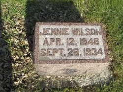
Jennie Esther Hakeman Wilson
| Birth | : | 12 Apr 1846 Lincolnshire, England |
| Death | : | 28 Sep 1934 Okoboji, Dickinson County, Iowa, USA |
| Burial | : | Olive Lawn Memorial Park, La Mirada, Los Angeles County, USA |
| Coordinate | : | 33.9038700, -118.0114400 |
| Plot | : | 1-33-1/W3 |
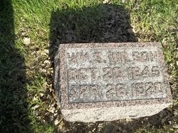
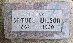
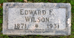
| Description | : | Parents are Isaac Hakeman & Elizabeth E. (Thompson) Hakeman Wife of William Scott Wilson (married, July 4, 1866, USA) Children are: Samuel A. (preceded mother in death) Oliver I., m. Lizzie Green, (Oliver died Aug. 12, 1953, Charles City, Iowa, aged 84 years.) Edward F. (preceded mother in death) dau., m. E. F. Miller dau., m. George McCutchin Mary A. (preceded parents in death) Charles H. Wilson --------- Occupation: Postmistress, 25 years. *Came to the USA with her parents at one years of age, having her first birthday while crossing the ocean from England. --------- Obituary is published in The Spirit Lake Beacon, Oct. 4, 1934. --------- |
frequently asked questions (FAQ):
-
Where is Jennie Esther Hakeman Wilson's memorial?
Jennie Esther Hakeman Wilson's memorial is located at: Olive Lawn Memorial Park, La Mirada, Los Angeles County, USA.
-
When did Jennie Esther Hakeman Wilson death?
Jennie Esther Hakeman Wilson death on 28 Sep 1934 in Okoboji, Dickinson County, Iowa, USA
-
Where are the coordinates of the Jennie Esther Hakeman Wilson's memorial?
Latitude: 33.9038700
Longitude: -118.0114400
Family Members:
Parent

Spouse
Siblings
Children
Flowers:


Nearby Cemetories:
1. Cinco Camp Burial Grounds
Cantil, Kern County, USA
Coordinate: 33.9277710, -118.0649960
2. Norwalk State Hospital Cemetery
Norwalk, Los Angeles County, USA
Coordinate: 33.9277710, -118.0649960
3. Olive Grove Cemetery
Whittier, Los Angeles County, USA
Coordinate: 33.9452300, -118.0511700
4. Little Lake Cemetery
Santa Fe Springs, Los Angeles County, USA
Coordinate: 33.9317900, -118.0779100
5. First Presbyterian Church Memorial Gardens
Fullerton, Orange County, USA
Coordinate: 33.8788600, -117.9417400
6. Saint Josephs Episcopal Church Columbarium
Buena Park, Orange County, USA
Coordinate: 33.8415590, -118.0280360
7. Paradise Memorial Park
Santa Fe Springs, Los Angeles County, USA
Coordinate: 33.9354540, -118.0869900
8. Artesia Cemetery
Cerritos, Los Angeles County, USA
Coordinate: 33.8717003, -118.0958023
9. Loma Vista Memorial Park
Fullerton, Orange County, USA
Coordinate: 33.9016991, -117.9167023
10. Forest Lawn Memorial Park
Cypress, Orange County, USA
Coordinate: 33.8339005, -118.0560989
11. Young Israel Cemetery
Norwalk, Los Angeles County, USA
Coordinate: 33.9071000, -118.1081300
12. Mount Olive Cemetery
Whittier, Los Angeles County, USA
Coordinate: 33.9869003, -118.0453033
13. Broadway Cemetery
Whittier, Los Angeles County, USA
Coordinate: 33.9868088, -118.0460434
14. Saint Andrews Episcopal Church Columbarium
Fullerton, Orange County, USA
Coordinate: 33.8745900, -117.9051200
15. Memory Garden Memorial Park
Brea, Orange County, USA
Coordinate: 33.9336014, -117.9024963
16. Holy Cross Cemetery
Anaheim, Orange County, USA
Coordinate: 33.8236885, -117.9422226
17. Long Beach Police Academy K-9 Cemetery
Long Beach, Los Angeles County, USA
Coordinate: 33.8274000, -118.0895300
18. Saint Marks Episcopal Church Columbarium
Downey, Los Angeles County, USA
Coordinate: 33.9491800, -118.1271200
19. Downey District Cemetery
Downey, Los Angeles County, USA
Coordinate: 33.9102783, -118.1399994
20. Rose Hills Memorial Park
Whittier, Los Angeles County, USA
Coordinate: 34.0139900, -118.0253400
21. Anaheim Cemetery
Anaheim, Orange County, USA
Coordinate: 33.8422012, -117.8981018
22. Queen of Heaven Cemetery
Rowland Heights, Los Angeles County, USA
Coordinate: 33.9818993, -117.9092026
23. El Campo Santo Cemetery
Industry, Los Angeles County, USA
Coordinate: 34.0182300, -117.9630500
24. Magnolia Memorial Park
Garden Grove, Orange County, USA
Coordinate: 33.7843895, -117.9755478