

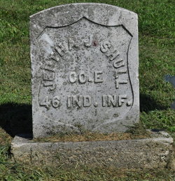
Jeptha Josiah Shull
| Birth | : | 14 Jul 1843 White County, Indiana, USA |
| Death | : | 8 Jun 1931 Logansport, Cass County, Indiana, USA |
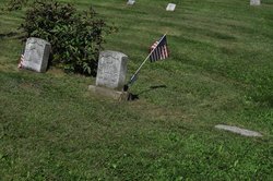
| Burial | : | Buckingham Cemetery, Traer, Tama County, USA |
| Coordinate | : | 42.2069016, -92.4741974 |
| Description | : | Civil War Co E 46th Ind Inf Machine Crashes Off Road Jeptha J. Shull, 87, of Burnettsville, Sustains Mortal injuries and Daughter Is Seriously Injured. BULLETIN--At 3 o'clock this afternoon, it was reported at the Cass county hospital that the condition of Mrs. E. M. Dunham, accident victim, was very critical. When an automobile plunged over an Embankment east of Pipe Creek Falls at 10:40 o'clock this morning Jeptha J. Shull. 87, Civil war veterans, of Burnettsville, suffered injuries that proved fatal two hours later, his daughter, Mrs. E. M. Dunham, this city, was seriously injured and three other... Read More |
frequently asked questions (FAQ):
-
Where is Jeptha Josiah Shull's memorial?
Jeptha Josiah Shull's memorial is located at: Buckingham Cemetery, Traer, Tama County, USA.
-
When did Jeptha Josiah Shull death?
Jeptha Josiah Shull death on 8 Jun 1931 in Logansport, Cass County, Indiana, USA
-
Where are the coordinates of the Jeptha Josiah Shull's memorial?
Latitude: 42.2069016
Longitude: -92.4741974
Family Members:
Parent
Spouse
Siblings
Children


Nearby Cemetories:
1. Buckingham Cemetery
Traer, Tama County, USA
Coordinate: 42.2069016, -92.4741974
2. Saint Pauls Catholic Cemetery
Traer, Tama County, USA
Coordinate: 42.1832000, -92.4688000
3. West Union Cemetery
Traer, Tama County, USA
Coordinate: 42.1817017, -92.4449997
4. Larch Hill Cemetery
Buckingham, Tama County, USA
Coordinate: 42.2638701, -92.4524057
5. Dinsdale Cemetery
Tama County, USA
Coordinate: 42.2472000, -92.5330963
6. Bakers Grove Cemetery
Traer, Tama County, USA
Coordinate: 42.1319008, -92.5143967
7. Grant Township Cemetery
Grant Township, Tama County, USA
Coordinate: 42.2571983, -92.5922012
8. Blessing Cemetery
Hudson, Black Hawk County, USA
Coordinate: 42.3116700, -92.4572200
9. Geneseo Cemetery
Buckingham, Tama County, USA
Coordinate: 42.2764370, -92.3523950
10. Spencer Cemetery
Dysart, Tama County, USA
Coordinate: 42.2592120, -92.3353840
11. Pleasant Hill Cemetery
Toledo, Tama County, USA
Coordinate: 42.1080000, -92.5595000
12. Oneida Cemetery
Clutier, Tama County, USA
Coordinate: 42.1007996, -92.3966980
13. Saint Wenceslaus Cemetery
Clutier, Tama County, USA
Coordinate: 42.0870000, -92.4460000
14. Dysart Cemetery
Dysart, Tama County, USA
Coordinate: 42.1608009, -92.3193970
15. Crystal Township Cemetery
Garwin, Tama County, USA
Coordinate: 42.1380997, -92.6264038
16. Hill Cemetery
Tama County, USA
Coordinate: 42.2542000, -92.3075027
17. Saint Josephs Catholic Cemetery
Benton County, USA
Coordinate: 42.1719017, -92.2981033
18. Lincoln Cemetery
Voorhies, Black Hawk County, USA
Coordinate: 42.3403015, -92.5227966
19. Queen of Heaven Cemetery
Reinbeck, Grundy County, USA
Coordinate: 42.3149000, -92.5960000
20. Reinbeck Cemetery
Reinbeck, Grundy County, USA
Coordinate: 42.3140600, -92.5992200
21. Clutier Cemetery
Clutier, Tama County, USA
Coordinate: 42.0792007, -92.3858032
22. Brown Bruce Township Cemetery
Benton County, USA
Coordinate: 42.2163430, -92.2799680
23. Fee Chapel Cemetery
Tama County, USA
Coordinate: 42.0643997, -92.5117035
24. Gethmann Cemetery
Gladbrook, Tama County, USA
Coordinate: 42.1893997, -92.6706009