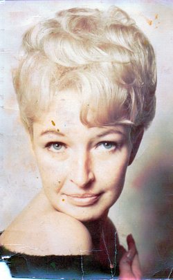
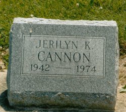
Jerilyn Kay “Jerry” Sering Cannon
| Birth | : | 27 Jul 1942 Hillsboro, Fountain County, Indiana, USA |
| Death | : | 4 Jun 1974 Baltimore, Baltimore City, Maryland, USA |
| Burial | : | Saint Joseph Cemetery, Lucinda, Clarion County, USA |
| Coordinate | : | 41.3112000, -79.3656000 |
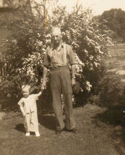
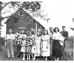
| Description | : | Jerilyn was raised in Hillsboro by her grandparents, Belva and Daley Harper. She moved to Baltimore in 1959 and married George Cannon, who survives. She leaves behind a son, George Jr. and a daughter, Cynthia Lynn, both of Baltimore, MD. She is also survived by her mother Betty J. Smith & a half-sister Karen Smith, both of Crown Point; her father & step-mother Russell D. & Beverly M. Sering of Dayton, OH; a half-sister Cheri of Crawfordsville; and 3 half-brothers, Dave, Steve and Bob Sering. |
frequently asked questions (FAQ):
-
Where is Jerilyn Kay “Jerry” Sering Cannon's memorial?
Jerilyn Kay “Jerry” Sering Cannon's memorial is located at: Saint Joseph Cemetery, Lucinda, Clarion County, USA.
-
When did Jerilyn Kay “Jerry” Sering Cannon death?
Jerilyn Kay “Jerry” Sering Cannon death on 4 Jun 1974 in Baltimore, Baltimore City, Maryland, USA
-
Where are the coordinates of the Jerilyn Kay “Jerry” Sering Cannon's memorial?
Latitude: 41.3112000
Longitude: -79.3656000
Family Members:
Parent
Spouse
Flowers:
Nearby Cemetories:
1. Independence Cemetery
West Freedom, Clarion County, USA
Coordinate: 41.3300000, -79.3438010
2. Helen Furnace Cemetery
Clarion County, USA
Coordinate: 41.2838000, -79.3210000
3. Miola Cemetery
Highland Township, Clarion County, USA
Coordinate: 41.2574997, -79.3367004
4. Saint Michael Catholic Cemetery
Fryburg, Clarion County, USA
Coordinate: 41.3452000, -79.4390000
5. Dehner Cemetery
Strobleton, Clarion County, USA
Coordinate: 41.3642006, -79.4160995
6. Anderson Farm Cemetery
Leeper, Clarion County, USA
Coordinate: 41.3592530, -79.3047000
7. Lickingville Cemetery
Lickingville, Clarion County, USA
Coordinate: 41.3795000, -79.3702000
8. Pioneer Cemetery
Fryburg, Clarion County, USA
Coordinate: 41.3540360, -79.4479899
9. Scotch Hill Union Cemetery
Scotch Hill, Clarion County, USA
Coordinate: 41.3240000, -79.2651000
10. Tylersburg Cemetery
Tylersburg, Clarion County, USA
Coordinate: 41.3824000, -79.3226000
11. Washington Cemetery
Frills Corners, Clarion County, USA
Coordinate: 41.3956000, -79.3770000
12. Good Shepherd Church Cemetery
Clarion County, USA
Coordinate: 41.3970080, -79.3449490
13. Allio Cemetery
Tylersburg, Clarion County, USA
Coordinate: 41.3920830, -79.3221500
14. Mount Zion Cemetery
Shippenville, Clarion County, USA
Coordinate: 41.2513300, -79.4584360
15. Venus Cemetery
Fryburg, Clarion County, USA
Coordinate: 41.3605995, -79.4693985
16. Pleasant Hill Cemetery
Shippenville, Clarion County, USA
Coordinate: 41.2483230, -79.4592570
17. Shotts-Hagen Cemetery
Tylersburg, Clarion County, USA
Coordinate: 41.3900846, -79.2962062
18. Emmanuel Cemetery
Shippenville, Clarion County, USA
Coordinate: 41.2534000, -79.4658000
19. Berlin-Knight Cemetery
Shippenville, Clarion County, USA
Coordinate: 41.2894000, -79.4906000
20. Clarion Cemetery
Clarion, Clarion County, USA
Coordinate: 41.2151210, -79.3922190
21. Old Methodist Cemetery
Clarion County, USA
Coordinate: 41.3671000, -79.4749000
22. Immaculate Conception Cemetery
Clarion, Clarion County, USA
Coordinate: 41.2132800, -79.3953800
23. Cedarview Memorial Park
Strattanville, Clarion County, USA
Coordinate: 41.2193985, -79.3003006
24. Fisher Presbyterian Cemetery
Fisher, Clarion County, USA
Coordinate: 41.2648000, -79.2413000


