

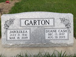
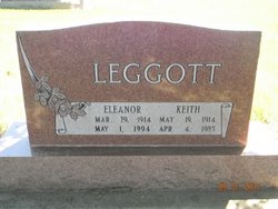
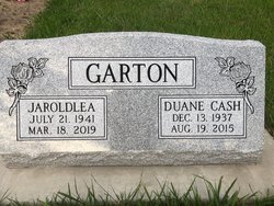
Jeroldlea “Jeri” Leggott Garton
| Birth | : | 21 Jul 1941 Elwood, Gosper County, Nebraska, USA |
| Death | : | 18 Mar 2019 Callaway, Custer County, Nebraska, USA |
| Burial | : | Robb Cemetery, Smithfield, Gosper County, USA |
| Coordinate | : | 40.6710691, -99.6996001 |
| Description | : | Jaroldlea “Jeri” Garton , 77, of Callaway, Nebraska formerly of Lexington passed Monday, March 18, 2019 at the Callaway Good Life Center in Callaway. She was born July 21, 1941 in Elwood, Nebraska to Keith and Eleanor (Harm) Leggott. She attended and graduated from Elwood High School. Jeri then went on to further her education at Lincoln School of Commerce and earned a secretarial degree. On December 16, 1961 she was united to Duane Garton and from this marriage two children were born, Jodi and Jason. The family made their home in Lexington where she worked at Platte... Read More |
frequently asked questions (FAQ):
-
Where is Jeroldlea “Jeri” Leggott Garton's memorial?
Jeroldlea “Jeri” Leggott Garton's memorial is located at: Robb Cemetery, Smithfield, Gosper County, USA.
-
When did Jeroldlea “Jeri” Leggott Garton death?
Jeroldlea “Jeri” Leggott Garton death on 18 Mar 2019 in Callaway, Custer County, Nebraska, USA
-
Where are the coordinates of the Jeroldlea “Jeri” Leggott Garton's memorial?
Latitude: 40.6710691
Longitude: -99.6996001
Family Members:
Parent

Spouse
Siblings

Flowers:


Nearby Cemetories:
1. Robb Cemetery
Smithfield, Gosper County, USA
Coordinate: 40.6710691, -99.6996001
2. Plum Creek Massacre Cemetery
Phelps County, USA
Coordinate: 40.6726840, -99.6058220
3. Evergreen Cemetery
Lexington, Dawson County, USA
Coordinate: 40.7639008, -99.6791992
4. Adullam Cemetery
Bertrand, Phelps County, USA
Coordinate: 40.6265000, -99.5856000
5. Quakerville Cemetery
Gosper County, USA
Coordinate: 40.6189003, -99.8097000
6. Keely Cemetery
Smithfield, Gosper County, USA
Coordinate: 40.5727500, -99.6563500
7. Hope Lutheran Cemetery
Smithfield, Gosper County, USA
Coordinate: 40.5667500, -99.6800000
8. Saint Anns Cemetery
Lexington, Dawson County, USA
Coordinate: 40.7789001, -99.7114029
9. First United Methodist Church Columbarium
Lexington, Dawson County, USA
Coordinate: 40.7810000, -99.7397000
10. Immanuel Cemetery
Bertrand, Phelps County, USA
Coordinate: 40.5682983, -99.6283035
11. Sandstrom Cemetery
Phelps County, USA
Coordinate: 40.5983009, -99.5661011
12. Greenwood Cemetery
Lexington, Dawson County, USA
Coordinate: 40.7956467, -99.7286682
13. Elwood Cemetery
Elwood, Gosper County, USA
Coordinate: 40.5999300, -99.8397300
14. Overton Cemetery
Overton, Dawson County, USA
Coordinate: 40.7317009, -99.5222015
15. Platte Valley Cemetery
Phelps County, USA
Coordinate: 40.6425018, -99.5028000
16. Highland Cemetery
Bertrand, Phelps County, USA
Coordinate: 40.5194016, -99.6430969
17. Mount Hope Cemetery
Dawson County, USA
Coordinate: 40.8293991, -99.6733017
18. Yoder Cemetery
Smithfield, Gosper County, USA
Coordinate: 40.4957000, -99.6845500
19. Williamsburg Cemetery
Phelps County, USA
Coordinate: 40.6490290, -99.4543150
20. Hewitt Cemetery
Lexington, Dawson County, USA
Coordinate: 40.8588982, -99.7769012
21. Fairfield Cemetery
Gosper County, USA
Coordinate: 40.4672012, -99.7549973
22. Buffalo Grove Presbyterian Church Cemetery
Buffalo, Dawson County, USA
Coordinate: 40.8721000, -99.8270000
23. Grace Cemetery
Cozad, Dawson County, USA
Coordinate: 40.8602982, -99.8644028
24. Pioneer Cemetery
Eustis, Frontier County, USA
Coordinate: 40.6632810, -100.0013730