
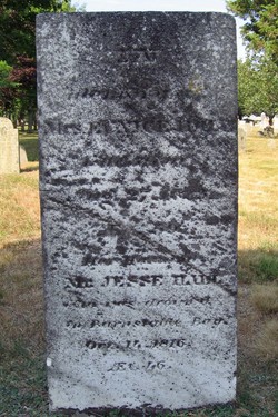
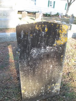
Jesse Hall
| Birth | : | 23 Jan 1770 Dennis, Barnstable County, Massachusetts, USA |
| Death | : | 14 Oct 1816 Dennis, Barnstable County, Massachusetts, USA |
| Burial | : | Dennis Village Cemetery, Dennis, Barnstable County, USA |
| Coordinate | : | 41.7373466, -70.1924286 |
| Inscription | : | Inscribed on the bottom half: In Memory of Mr Jesse Hall who was drowned in Barnstable Bay Oct. 14, 1816 AE'd 46 |
| Description | : | Jesse Hall was born to Josiah and Fear (Crowell) Hall. He married Eunice Howes, daughter of Thomas and Jerusha Howes. In 1816, he was knocked overboard by the boom from the Packet Sloop Sally, just a few hundred yards off Nobscusset Point in Dennis, MA. He shares a common gravestone with his wife Eunice who died in 1833. |
frequently asked questions (FAQ):
-
Where is Jesse Hall's memorial?
Jesse Hall's memorial is located at: Dennis Village Cemetery, Dennis, Barnstable County, USA.
-
When did Jesse Hall death?
Jesse Hall death on 14 Oct 1816 in Dennis, Barnstable County, Massachusetts, USA
-
Where are the coordinates of the Jesse Hall's memorial?
Latitude: 41.7373466
Longitude: -70.1924286
Family Members:
Parent
Spouse

Siblings
Children
Flowers:


Nearby Cemetories:
1. Dennis Village Cemetery
Dennis, Barnstable County, USA
Coordinate: 41.7373466, -70.1924286
2. Hall Cemetery
Dennis, Barnstable County, USA
Coordinate: 41.7435989, -70.1943970
3. Howes Family Cemetery
Dennis, Barnstable County, USA
Coordinate: 41.7344017, -70.2014008
4. Nobscusset Indian Burial Ground
Dennis, Barnstable County, USA
Coordinate: 41.7451330, -70.1830350
5. Corporation Beach Memorial Park
Dennis, Barnstable County, USA
Coordinate: 41.7507000, -70.1875000
6. Paddock Cemetery
East Dennis, Barnstable County, USA
Coordinate: 41.7430992, -70.1735992
7. Worden Cemetery
East Dennis, Barnstable County, USA
Coordinate: 41.7425003, -70.1517029
8. Bass Hole Memorial Garden
Yarmouth Port, Barnstable County, USA
Coordinate: 41.7228810, -70.2355470
9. Sears Cemetery
West Brewster, Barnstable County, USA
Coordinate: 41.7442017, -70.1457977
10. Quaker Cemetery
Dennis, Barnstable County, USA
Coordinate: 41.7043991, -70.1713028
11. Oak Ridge Cemetery
South Dennis, Barnstable County, USA
Coordinate: 41.7111015, -70.1556015
12. Quivet Neck Cemetery
East Dennis, Barnstable County, USA
Coordinate: 41.7500000, -70.1417007
13. Ancient Cemetery
Yarmouth Port, Barnstable County, USA
Coordinate: 41.7111015, -70.2332993
14. Red Top Cemetery
Brewster, Barnstable County, USA
Coordinate: 41.7433014, -70.1342010
15. Thacher Property Burial Ground
Yarmouth Port, Barnstable County, USA
Coordinate: 41.7084800, -70.2438500
16. Ancient Cemetery
South Dennis, Barnstable County, USA
Coordinate: 41.6892014, -70.1568985
17. Woodside Cemetery
Yarmouth Port, Barnstable County, USA
Coordinate: 41.7000008, -70.2472000
18. Dillingham Cemetery
Brewster, Barnstable County, USA
Coordinate: 41.7444000, -70.1183014
19. Memorial Park
South Yarmouth, Barnstable County, USA
Coordinate: 41.6776350, -70.1925520
20. Georgetown Cemetery
South Yarmouth, Barnstable County, USA
Coordinate: 41.6731415, -70.1818695
21. Indian Memorial Cemetery
South Yarmouth, Barnstable County, USA
Coordinate: 41.6704400, -70.1913900
22. North Harwich Cemetery
North Harwich, Barnstable County, USA
Coordinate: 41.6956700, -70.1221700
23. South Dennis Cemetery
South Dennis, Barnstable County, USA
Coordinate: 41.6761017, -70.1556015
24. Quaker Meeting House Cemetery
South Yarmouth, Barnstable County, USA
Coordinate: 41.6689987, -70.1846008