
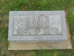

Jessie Ruth Seeger Coe
| Birth | : | 16 Apr 1897 Clarks Hill, Tippecanoe County, Indiana, USA |
| Death | : | 16 Dec 1988 Lafayette, Tippecanoe County, Indiana, USA |
| Burial | : | Los Molinos Cemetery, Los Molinos, Tehama County, USA |
| Coordinate | : | 40.0475650, -122.1011820 |
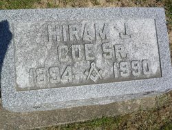
| Description | : | Clarks Hill - Ruth Seeger Coe, 91, of Clarks Hill, died at 11:45 a.m. Friday in the Americana Nursing Center where she had resided since August. Mrs. Coe was born in Clarks Hill on April 6, 1897. Her marriage was to Hiram J. Coe Sr., on March 30, 1916. She and her husband observed their 72nd wedding anniversary in March. A lifelong resident of Clarks Hill, Mrs. Coe graduated from Clarks Hill High School in 1914. She was the surviving member of the class of 1914. Mrs. Coe was a member of the Clarks... Read More |
frequently asked questions (FAQ):
-
Where is Jessie Ruth Seeger Coe's memorial?
Jessie Ruth Seeger Coe's memorial is located at: Los Molinos Cemetery, Los Molinos, Tehama County, USA.
-
When did Jessie Ruth Seeger Coe death?
Jessie Ruth Seeger Coe death on 16 Dec 1988 in Lafayette, Tippecanoe County, Indiana, USA
-
Where are the coordinates of the Jessie Ruth Seeger Coe's memorial?
Latitude: 40.0475650
Longitude: -122.1011820
Family Members:
Flowers:


Nearby Cemetories:
1. Los Molinos Cemetery
Los Molinos, Tehama County, USA
Coordinate: 40.0475650, -122.1011820
2. Tehama Cemetery
Tehama, Tehama County, USA
Coordinate: 40.0233002, -122.1433029
3. Growney Ranch Family Cemetery
Red Bluff, Tehama County, USA
Coordinate: 40.1167300, -122.1952500
4. New Clairvaux Abbey Cemetery
Vina, Tehama County, USA
Coordinate: 39.9381450, -122.0641890
5. Vina Cemetery
Vina, Tehama County, USA
Coordinate: 39.9636440, -121.9957070
6. Sunset Hill Cemetery
Corning, Tehama County, USA
Coordinate: 39.9271600, -122.1586100
7. Oak Hill Cemetery
Red Bluff, Tehama County, USA
Coordinate: 40.1699982, -122.2433014
8. Red Bluff Memorial Chapel Mausoleum & Columbarium
Red Bluff, Tehama County, USA
Coordinate: 40.1717130, -122.2466860
9. Saint Mary's Cemetery
Red Bluff, Tehama County, USA
Coordinate: 40.1716995, -122.2521973
10. Kirkwood Cemetery
Corning, Tehama County, USA
Coordinate: 39.8624992, -122.1519012
11. Pine Creek Cemetery
Chico, Butte County, USA
Coordinate: 39.8617240, -121.9842480
12. Red Bank Cemetery
Red Bank, Tehama County, USA
Coordinate: 40.1036970, -122.4458540
13. Cameron-Davis Cemetery
Tehama County, USA
Coordinate: 40.2709800, -121.8778500
14. Orland Masonic Cemetery
Orland, Glenn County, USA
Coordinate: 39.7684760, -122.1943310
15. Elmore Cemetery
Flournoy, Tehama County, USA
Coordinate: 39.8642006, -122.4005966
16. Bragg Cemetery
Nord, Butte County, USA
Coordinate: 39.7750980, -121.9568170
17. Inks Creek Cemetery
Tehama County, USA
Coordinate: 40.3419800, -122.1297100
18. Graves Cemetery
Orland, Glenn County, USA
Coordinate: 39.7827988, -122.2930984
19. Cohasset Cemetery
Cohasset, Butte County, USA
Coordinate: 39.9124880, -121.7333220
20. Benner Family Cemetery
Tehama County, USA
Coordinate: 40.1826890, -121.7183500
21. Cottonwood Creek Ranch Cemetery
Cottonwood, Shasta County, USA
Coordinate: 40.3663100, -122.2598800
22. Paskenta Cemetery
Corning, Tehama County, USA
Coordinate: 39.9002991, -122.5089035
23. Orland Catholic Cemetery
Orland, Glenn County, USA
Coordinate: 39.7030983, -122.1393967
24. Orland IOOF Cemetery
Orland, Glenn County, USA
Coordinate: 39.7026000, -122.1401000