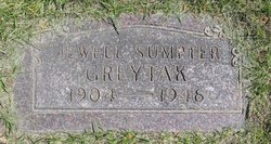
Jewell Bernice Sumpter Greytak
| Birth | : | 27 Jul 1904 Clarence, Shelby County, Missouri, USA |
| Death | : | 31 Jul 1946 Great Falls, Cascade County, Montana, USA |
| Burial | : | Live Oak Memorial Park, Monrovia, Los Angeles County, USA |
| Coordinate | : | 34.1319500, -117.9960700 |
| Plot | : | Section 12 |
| Description | : | The following provided by Find A Grave contributor "Cara": Great Falls Tribune (MT), 1 Aug 1946 Mrs. Albert Greytak Rites are Friday Funeral services for Mrs. Albert Greytak, 42, 620 Fifth avenue north, will be held from the Croxford mortuary Friday afternoon at 3 with Rev. Paul W. Dierberger conducting the service. Burial will be in the family plot in Highland cemetery. Mrs. Greytak died in a local hospital Wednesday. Mrs. Greytak was born Jewell Bernice Sumpter, July 27, 1904, in Clarence, Mo. She was married to Greytak, an ACM employee, Aug. 11, 1926. Survivors include the husband and... Read More |
frequently asked questions (FAQ):
-
Where is Jewell Bernice Sumpter Greytak's memorial?
Jewell Bernice Sumpter Greytak's memorial is located at: Live Oak Memorial Park, Monrovia, Los Angeles County, USA.
-
When did Jewell Bernice Sumpter Greytak death?
Jewell Bernice Sumpter Greytak death on 31 Jul 1946 in Great Falls, Cascade County, Montana, USA
-
Where are the coordinates of the Jewell Bernice Sumpter Greytak's memorial?
Latitude: 34.1319500
Longitude: -117.9960700
Family Members:
Flowers:
Nearby Cemetories:
1. Live Oak Memorial Park
Monrovia, Los Angeles County, USA
Coordinate: 34.1319500, -117.9960700
2. Sierra Madre Pioneer Cemetery
Sierra Madre, Los Angeles County, USA
Coordinate: 34.1620290, -118.0417850
3. Episcopal Church of the Ascension Memorial Garden
Sierra Madre, Los Angeles County, USA
Coordinate: 34.1659355, -118.0518723
4. Mater Dolorosa Passionist Retreat Center Cemetery
Sierra Madre, Los Angeles County, USA
Coordinate: 34.1709633, -118.0647049
5. Savannah Memorial Park Cemetery
Rosemead, Los Angeles County, USA
Coordinate: 34.0811768, -118.0678177
6. Fairmount Cemetery
Glendora, Los Angeles County, USA
Coordinate: 34.1407661, -117.8892365
7. Saint Marthas Episcopal Church Columbarium
Covina, Los Angeles County, USA
Coordinate: 34.0655300, -117.9165200
8. San Gabriel Cemetery
San Gabriel, Los Angeles County, USA
Coordinate: 34.1113014, -118.1086273
9. Holy Trinity Episcopal Church Memorial Garden
Covina, Los Angeles County, USA
Coordinate: 34.0865900, -117.8922300
10. Huntington Library and Botanical Gardens Mausoleum
San Marino, Los Angeles County, USA
Coordinate: 34.1289902, -118.1135712
11. San Gabriel Mission Cemetery
San Gabriel, Los Angeles County, USA
Coordinate: 34.0974998, -118.1062012
12. Oakdale Memorial Park
Glendora, Los Angeles County, USA
Coordinate: 34.1121330, -117.8758698
13. Grace Episcopal Church Columbarium
Glendora, Los Angeles County, USA
Coordinate: 34.1382900, -117.8576000
14. El Campo Santo Cemetery
Industry, Los Angeles County, USA
Coordinate: 34.0182300, -117.9630500
15. Rubel Castle
Glendora, Los Angeles County, USA
Coordinate: 34.1503340, -117.8546380
16. Rose Hills Memorial Park
Whittier, Los Angeles County, USA
Coordinate: 34.0139900, -118.0253400
17. Chapel of Saint Nektarios Reliquary
Covina, Los Angeles County, USA
Coordinate: 34.0991400, -117.8554100
18. All Saints Episcopal Church Columbarium
Pasadena, Los Angeles County, USA
Coordinate: 34.1480293, -118.1428070
19. Resurrection Cemetery
Montebello, Los Angeles County, USA
Coordinate: 34.0429993, -118.1007004
20. Lippincott Torrey and Eaton Mausoleum
Pasadena, Los Angeles County, USA
Coordinate: 34.1444984, -118.1504677
21. Saint James Episcopal Church Memorial Garden
South Pasadena, Los Angeles County, USA
Coordinate: 34.1116500, -118.1535400
22. Mountain View Cemetery and Mausoleum
Altadena, Los Angeles County, USA
Coordinate: 34.1861000, -118.1481018
23. Forest Lawn Memorial Park
Covina, Los Angeles County, USA
Coordinate: 34.0628014, -117.8368988
24. Church of the Angels Mausoleum
Pasadena, Los Angeles County, USA
Coordinate: 34.1255600, -118.1761400


