
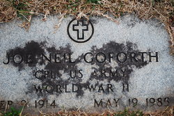
Joe Corneilus “Neil” Goforth
| Birth | : | 9 Sep 1914 |
| Death | : | 19 May 1985 |
| Burial | : | Round Hill Baptist Church Cemetery, Union Mills, Rutherford County, USA |
| Coordinate | : | 35.4934690, -81.9711200 |
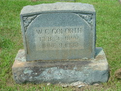
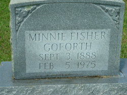
| Description | : | s/o William Clements Goforth, Minnie Fisher h/o Ruth Walters occupation: Truck Driver ------- U.S. World War II Army Enlistment Records, 1938-1946 about Joe N Goforth Name:Joe N Goforth Birth Year:1914 Race:White, citizen (White) Nativity State or Country:North Carolina State of Residence:Virginia County or City:Pittsylvania Enlistment Date:18 Jun 1943 Enlistment State:Virginia Enlistment City:Roanoke Branch:No branch assignment Grade:Private Grade Code:Private ------- |
frequently asked questions (FAQ):
-
Where is Joe Corneilus “Neil” Goforth's memorial?
Joe Corneilus “Neil” Goforth's memorial is located at: Round Hill Baptist Church Cemetery, Union Mills, Rutherford County, USA.
-
When did Joe Corneilus “Neil” Goforth death?
Joe Corneilus “Neil” Goforth death on 19 May 1985 in
-
Where are the coordinates of the Joe Corneilus “Neil” Goforth's memorial?
Latitude: 35.4934690
Longitude: -81.9711200
Family Members:
Parent
Spouse

Siblings
Flowers:


Nearby Cemetories:
1. Round Hill Baptist Church Cemetery
Union Mills, Rutherford County, USA
Coordinate: 35.4934690, -81.9711200
2. Grace Tabernacle Cemetery
Union Mills, Rutherford County, USA
Coordinate: 35.4957850, -81.9777540
3. Union Hill A.M.E. Zion Church Cemetery
Union Mills, Rutherford County, USA
Coordinate: 35.4850770, -81.9671190
4. Mount Pleasant CME Church Cemetery
Union Mills, Rutherford County, USA
Coordinate: 35.4818800, -81.9592700
5. Flack Family Cemetery
Union Mills, Rutherford County, USA
Coordinate: 35.4765400, -81.9784300
6. Liberty Hill Cemetery
Rutherford County, USA
Coordinate: 35.4791985, -81.9847031
7. Pleasant Hill Cemetery
Rutherford County, USA
Coordinate: 35.5022011, -81.9441986
8. Old Thermal City Church Cemetery
Thermal City, Rutherford County, USA
Coordinate: 35.5173120, -81.9706250
9. Union Mills Presbyterian Church Cemetery
Union Mills, Rutherford County, USA
Coordinate: 35.4824350, -81.9440390
10. Hillsdale Church Cemetery
Rutherfordton, Rutherford County, USA
Coordinate: 35.4849150, -82.0134380
11. Joseph Baxter Cemetery
Union Mills, Rutherford County, USA
Coordinate: 35.4529650, -81.9594860
12. Little White Country Church Cemetery
Rutherfordton, Rutherford County, USA
Coordinate: 35.4487152, -81.9854279
13. Centennial Cemetery
Rutherford County, USA
Coordinate: 35.4655991, -81.9206009
14. Gilkey United Methodist Church Cemetery
Rutherfordton, Rutherford County, USA
Coordinate: 35.4428110, -81.9773740
15. Gilkey Church of God Cemetery
Rutherfordton, Rutherford County, USA
Coordinate: 35.4424690, -81.9790850
16. Piney Ridge C.M.E Cemetery
Rutherfordton, Rutherford County, USA
Coordinate: 35.4467490, -81.9382130
17. Oak Springs Baptist Church Cemetery
Rutherford County, USA
Coordinate: 35.4437990, -81.9396900
18. Camp Creek Baptist Church Cemetery
Union Mills, Rutherford County, USA
Coordinate: 35.5141983, -81.9039001
19. Pine Ridge Mennonite Church Cemetery
Rutherfordton, Rutherford County, USA
Coordinate: 35.4568660, -82.0358090
20. Welcome Home Baptist Church Cemetery
Gilkey, Rutherford County, USA
Coordinate: 35.5118310, -82.0482780
21. Westminister Baptist Church Cemetery
Rutherfordton, Rutherford County, USA
Coordinate: 35.4647750, -81.8927880
22. Gilboa United Methodist Church Cemetery
Rutherfordton, Rutherford County, USA
Coordinate: 35.4236130, -81.9782150
23. Mountain Creek Baptist Church Cemetery
Rutherfordton, Rutherford County, USA
Coordinate: 35.4253006, -81.9985962
24. Brackettown Cemetery
McDowell County, USA
Coordinate: 35.5532990, -81.9207993