


Joe D Steenhard
| Birth | : | 23 Jan 1889 |
| Death | : | 14 Aug 1933 Hampton, Franklin County, Iowa, USA |
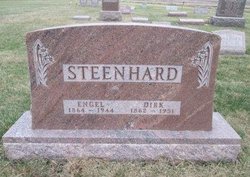
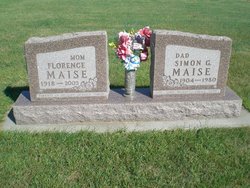
| Burial | : | Zion Reformed Church Cemetery, Franklin County, USA |
| Coordinate | : | 42.8413887, -93.3188934 |
| Description | : | Two persons were killed and three others injured when a car driven by Buford C. Gross, of Thornton, collided with one owned by Joe Steenhard and driven by his 20 year old son, Dick Steenhard, at the intersection of the Latimer-Thornton road and the Franklin-Cerro Gordo county line seven miles west of there last Monday afternoon at 2:30 P.M. The dead are Joe Steenhard and Mrs. Joe Steenhard. The injured are George Steenhard and Dick Steenhard, sons of Mr. and Mrs. Joe Steenhard, and Buford Gross, driver of the other car. Mrs. Steenhard suffered a broken neck and died instantly.... Read More |
frequently asked questions (FAQ):
-
Where is Joe D Steenhard's memorial?
Joe D Steenhard's memorial is located at: Zion Reformed Church Cemetery, Franklin County, USA.
-
When did Joe D Steenhard death?
Joe D Steenhard death on 14 Aug 1933 in Hampton, Franklin County, Iowa, USA
-
Where are the coordinates of the Joe D Steenhard's memorial?
Latitude: 42.8413887
Longitude: -93.3188934
Family Members:
Parent

Spouse
Siblings
Children

Flowers:


Nearby Cemetories:
1. Zion Reformed Church Cemetery
Franklin County, USA
Coordinate: 42.8413887, -93.3188934
2. Old Chapin Cemetery
Chapin, Franklin County, USA
Coordinate: 42.8232994, -93.2624969
3. Marion Center Cemetery
Latimer, Franklin County, USA
Coordinate: 42.7738991, -93.3178024
4. Shobes Grove Cemetery
Franklin County, USA
Coordinate: 42.9000015, -93.2722168
5. Way Side Cemetery
Chapin, Franklin County, USA
Coordinate: 42.8293991, -93.2225037
6. Richland Lutheran Cemetery
Thornton, Cerro Gordo County, USA
Coordinate: 42.9086113, -93.3683319
7. Saint Pauls Evangelical Lutheran Cemetery
Latimer, Franklin County, USA
Coordinate: 42.7652817, -93.3719406
8. Trinity Lutheran Cemetery
Hampton, Franklin County, USA
Coordinate: 42.7667007, -93.2518997
9. Hillside Cemetery
Sheffield, Franklin County, USA
Coordinate: 42.9006004, -93.2007980
10. Pleasant Valley Township Cemetery
Swaledale, Cerro Gordo County, USA
Coordinate: 42.9505615, -93.3216705
11. Alexander Cemetery
Alexander, Franklin County, USA
Coordinate: 42.8041687, -93.4591675
12. Coulter Cemetery
Coulter, Franklin County, USA
Coordinate: 42.7388916, -93.3716736
13. Holland Cemetery
Wisner Township, Franklin County, USA
Coordinate: 42.8638916, -93.4791718
14. Pleasant View Cemetery
Thornton, Cerro Gordo County, USA
Coordinate: 42.9524994, -93.3897018
15. Saint Johns Lutheran Cemetery
Hampton, Franklin County, USA
Coordinate: 42.7197189, -93.3397217
16. Hampton Cemetery
Hampton, Franklin County, USA
Coordinate: 42.7452812, -93.1975021
17. Saint Peter's Lutheran Church Cemetery
Coulter, Franklin County, USA
Coordinate: 42.7167015, -93.3803024
18. Meservey Cemetery
Meservey, Franklin County, USA
Coordinate: 42.9080582, -93.4786072
19. Saint John Zion Cemetery
Sheffield, Franklin County, USA
Coordinate: 42.8969002, -93.1472015
20. Richard Cemetery
Meservey, Cerro Gordo County, USA
Coordinate: 42.9089012, -93.4925003
21. Sacred Heart Cemetery
Rockwell, Cerro Gordo County, USA
Coordinate: 42.9592018, -93.1913986
22. Rockwell Cemetery
Rockwell, Cerro Gordo County, USA
Coordinate: 42.9786000, -93.1919000
23. Immanuel Reformed Cemetery
Belmond, Wright County, USA
Coordinate: 42.8635000, -93.5484000
24. Hansell Cemetery
Franklin County, USA
Coordinate: 42.7666702, -93.1047211