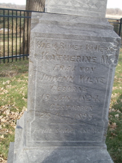
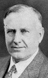
| Birth | : | 14 Oct 1833 Sage, Landkreis Oldenburg, Lower Saxony (Niedersachsen), Germany |
| Death | : | 23 Nov 1923 Shell Creek Township, Colfax County, Nebraska, USA |
| Burial | : | Oak Ridge Cemetery, Southbridge, Worcester County, USA |
| Coordinate | : | 42.0718430, -72.0325680 |
| Description | : | Web site: http://www.usgennet.org/usa/ne/county/platte/vitals/luschens.html LUTJELUSCHEN, JOHANN H. (October 14, 1833 - November 23, 1923) - [The Columbus Daily Telegram, November 23, 1923] John Henry Lutjeluschen, 90 years old, who had the distinction of being one of the oldest living pioneers of Platte county, died at his old home farm on Shell creek, 13 miles northeast of Columbus, at 5:30 a.m. today. His death was caused by pneumonia and followed an illness of only two days. Up to the time he was stricken this week he enjoyed exceptionally robust health for one of his extreme age and retained the use... Read More |
frequently asked questions (FAQ):
-
Where is Johann Heinrich Lutjeluschen's memorial?
Johann Heinrich Lutjeluschen's memorial is located at: Oak Ridge Cemetery, Southbridge, Worcester County, USA.
-
When did Johann Heinrich Lutjeluschen death?
Johann Heinrich Lutjeluschen death on 23 Nov 1923 in Shell Creek Township, Colfax County, Nebraska, USA
-
Where are the coordinates of the Johann Heinrich Lutjeluschen's memorial?
Latitude: 42.0718430
Longitude: -72.0325680
Family Members:
Parent
Spouse
Siblings
Children
Flowers:
Nearby Cemetories:
1. Oak Ridge Cemetery
Southbridge, Worcester County, USA
Coordinate: 42.0718430, -72.0325680
2. Saint Marys Cemetery
Southbridge, Worcester County, USA
Coordinate: 42.0805900, -72.0242000
3. Old Notre Dame Cemetery
Southbridge, Worcester County, USA
Coordinate: 42.0806900, -72.0228200
4. Saint George Cemetery
Southbridge, Worcester County, USA
Coordinate: 42.0833015, -72.0353012
5. Saint Hedwig Cemetery
Southbridge, Worcester County, USA
Coordinate: 42.0456000, -72.0141400
6. New Notre Dame Cemetery
Southbridge, Worcester County, USA
Coordinate: 42.0443990, -72.0138680
7. Morse Cemetery
Southbridge, Worcester County, USA
Coordinate: 42.0381860, -72.0114000
8. Blackmer Cemetery
Dudley, Worcester County, USA
Coordinate: 42.0518500, -71.9814700
9. Dresser Cemetery
Charlton, Worcester County, USA
Coordinate: 42.0949300, -71.9788800
10. Old Burial Ground
Sturbridge, Worcester County, USA
Coordinate: 42.1074500, -72.0805700
11. North Cemetery
Sturbridge, Worcester County, USA
Coordinate: 42.1128006, -72.0768967
12. Albee-Durfee Cemetery
Dudley, Worcester County, USA
Coordinate: 42.0527992, -71.9593964
13. Chase Family Plot
Dudley, Worcester County, USA
Coordinate: 42.0807000, -71.9539000
14. Barefoot Cemetery
Charlton, Worcester County, USA
Coordinate: 42.1307800, -72.0231100
15. Fitts Burial Yard
Charlton, Worcester County, USA
Coordinate: 42.0920900, -71.9550900
16. Browning Cemetery
Dudley, Worcester County, USA
Coordinate: 42.0505560, -71.9555600
17. Quinebaug Cemetery
Dudley, Worcester County, USA
Coordinate: 42.0335500, -71.9601100
18. Waldron Cemetery
Dudley, Worcester County, USA
Coordinate: 42.0697100, -71.9413700
19. Saint Anne Cemetery
Sturbridge, Worcester County, USA
Coordinate: 42.1185989, -72.1082993
20. Bay Path Cemetery
Charlton, Worcester County, USA
Coordinate: 42.1308320, -71.9687870
21. Westridge Cemetery
Charlton, Worcester County, USA
Coordinate: 42.1344890, -71.9724550
22. Union Cemetery
Charlton, Worcester County, USA
Coordinate: 42.1444016, -71.9957962
23. Corbin Cemetery
Dudley, Worcester County, USA
Coordinate: 42.0548100, -71.9280900
24. Village Cemetery
Dudley, Worcester County, USA
Coordinate: 42.0494800, -71.9274000


