
| Birth | : | 1820 Germany |
| Death | : | 28 Jun 1892 |
| Burial | : | Batavia Cemetery, Batavia, Jefferson County, USA |
| Coordinate | : | 40.9977080, -92.1661100 |
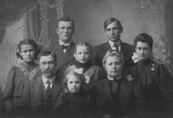
| Description | : | Courtesy of iagenweb.org/jefferson - "Portrait & Biographical Album", Jefferson & Van Buren Counties, Pub. Chicago, 1890, Pages 489-490: JOHN ANDREW KRAMER, highly respected citizen and leading farmer of Locust Grove Township, Jefferson County, was born near Stuttgart, Germany, in 1820, and was the oldest son in the family of Jacob and Johanna (NOTZ) KRAMER. The days of his boyhood and youth were spent at home, and in accordance with the laws of his native land he was for nearly six years in the army. Wishing to better his condition and believing the opportunities afforded by the old world were inferior to the... Read More |
frequently asked questions (FAQ):
-
Where is John Andrew Kramer's memorial?
John Andrew Kramer's memorial is located at: Batavia Cemetery, Batavia, Jefferson County, USA.
-
When did John Andrew Kramer death?
John Andrew Kramer death on 28 Jun 1892 in
-
Where are the coordinates of the John Andrew Kramer's memorial?
Latitude: 40.9977080
Longitude: -92.1661100
Family Members:
Spouse

Children
Flowers:


Nearby Cemetories:
1. Batavia Cemetery
Batavia, Jefferson County, USA
Coordinate: 40.9977080, -92.1661100
2. Courtney Cemetery
Jefferson County, USA
Coordinate: 40.9997711, -92.1788559
3. Holmes Family Cemetery
Batavia, Jefferson County, USA
Coordinate: 41.0175666, -92.1785349
4. Brethren Cemetery
Batavia, Jefferson County, USA
Coordinate: 40.9768000, -92.1240000
5. Coon Cemetery
Jefferson County, USA
Coordinate: 41.0266991, -92.1243973
6. Walnut Hill Cemetery
Jefferson County, USA
Coordinate: 41.0416985, -92.1355972
7. Morgan Burial Plot
Des Moines Township, Jefferson County, USA
Coordinate: 40.9837160, -92.0964340
8. Des Moines River Cemetery
Wapello County, USA
Coordinate: 40.9463000, -92.2042000
9. Rominger Cemetery
Batavia, Jefferson County, USA
Coordinate: 40.9379000, -92.1503000
10. Koons Cemetery
Locust Grove Township, Jefferson County, USA
Coordinate: 41.0286410, -92.0948960
11. Schrom Cemetery
Wapello County, USA
Coordinate: 41.0586014, -92.1885986
12. Sterner Cemetery
Bladensburg, Wapello County, USA
Coordinate: 41.0125008, -92.2497025
13. Gregg Cemetery
Jefferson County, USA
Coordinate: 41.0078011, -92.0811005
14. McCleary Cemetery
Jefferson County, USA
Coordinate: 40.9892006, -92.0805969
15. Ellsworth Cemetery
Ashland, Wapello County, USA
Coordinate: 40.9500182, -92.2251806
16. Gantz Cemetery
Abingdon, Jefferson County, USA
Coordinate: 41.0464000, -92.1017000
17. Ashland Cemetery
Ashland, Wapello County, USA
Coordinate: 40.9570000, -92.2410000
18. Gray Family Cemetery
Abingdon, Jefferson County, USA
Coordinate: 41.0722387, -92.1529565
19. Hackney Grave
Wapello County, USA
Coordinate: 40.9833429, -92.2640634
20. Brumsey Cemetery
Agency, Wapello County, USA
Coordinate: 41.0097386, -92.2668483
21. Smith Cemetery
Jefferson County, USA
Coordinate: 41.0758018, -92.1744003
22. Bradfield Plot
Locust Grove Township, Jefferson County, USA
Coordinate: 41.0615330, -92.1014040
23. Eldon Cemetery
Eldon, Wapello County, USA
Coordinate: 40.9296989, -92.2249985
24. Abingdon Cemetery
Abingdon, Jefferson County, USA
Coordinate: 41.0821720, -92.1363580