
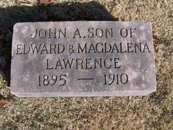
John Andrew Lawrence
| Birth | : | 21 Aug 1895 |
| Death | : | 6 May 1910 |
| Burial | : | Grano Cemetery, Grano, Renville County, USA |
| Coordinate | : | 48.6136017, -101.6038971 |
| Description | : | The son of, Edward and Magdalena Lawrence. He graduated from Lancaster High School with The Class of 1913, Lancaster, Ohio and SCHOOL COLORS were PURPLE and GOLD. |
frequently asked questions (FAQ):
-
Where is John Andrew Lawrence's memorial?
John Andrew Lawrence's memorial is located at: Grano Cemetery, Grano, Renville County, USA.
-
When did John Andrew Lawrence death?
John Andrew Lawrence death on 6 May 1910 in
-
Where are the coordinates of the John Andrew Lawrence's memorial?
Latitude: 48.6136017
Longitude: -101.6038971
Family Members:
Parent

Siblings
Flowers:


Nearby Cemetories:
1. Grano Cemetery
Grano, Renville County, USA
Coordinate: 48.6136017, -101.6038971
2. Gethsemane Cemetery
Carpio, Ward County, USA
Coordinate: 48.5747261, -101.7124481
3. Saint Johns Cemetery
Lansford, Bottineau County, USA
Coordinate: 48.6314011, -101.3961029
4. Saint Henrys Cemetery
Renville County, USA
Coordinate: 48.4846992, -101.5108032
5. Nazareth Lutheran Cemetery
Renville County, USA
Coordinate: 48.4733180, -101.6480450
6. Lansford Cemetery
Lansford, Bottineau County, USA
Coordinate: 48.6189003, -101.3867035
7. Mohall Cemetery
Cut Bank Township, Bottineau County, USA
Coordinate: 48.7627983, -101.4850006
8. Shook Cemetery
Renville County, USA
Coordinate: 48.5419273, -101.3651505
9. Greenfield Cemetery
Ward County, USA
Coordinate: 48.5974998, -101.8653030
10. First Lutheran Cemetery
Carpio, Ward County, USA
Coordinate: 48.4523544, -101.7316513
11. Saint Johns Cemetery
Carpio, Ward County, USA
Coordinate: 48.4425011, -101.6980972
12. Brotherhood Cemetery
Bottineau County, USA
Coordinate: 48.7780991, -101.4736023
13. McKinney Cemetery
Tolley, Renville County, USA
Coordinate: 48.7594261, -101.7830963
14. Trinity Cemetery
Tolley, Renville County, USA
Coordinate: 48.7261009, -101.8341980
15. Saint Johns United Lutheran Cemetery
Mohall, Renville County, USA
Coordinate: 48.7928429, -101.7149429
16. Saint Charles Cemetery
Tolley, Renville County, USA
Coordinate: 48.7340012, -101.8345108
17. Saint Anthonys Cemetery
Donnybrook, Ward County, USA
Coordinate: 48.4996986, -101.8731003
18. Donnybrook Community Cemetery
Donnybrook, Ward County, USA
Coordinate: 48.5171165, -101.8895264
19. Des Lacs Valley Cemetery
Carpio, Ward County, USA
Coordinate: 48.4011200, -101.6208900
20. Power Cemetery
Donnybrook, Ward County, USA
Coordinate: 48.5051627, -101.8884413
21. Holbrook Cemetery
Donnybrook, Ward County, USA
Coordinate: 48.5119019, -101.8944016
22. Johnson Cemetery
Ward County, USA
Coordinate: 48.4305992, -101.7872009
23. West Prairie Cemetery
Hartland, Ward County, USA
Coordinate: 48.4304543, -101.7879028
24. Renville Cemetery
Renville, Bottineau County, USA
Coordinate: 48.7485900, -101.3220700