
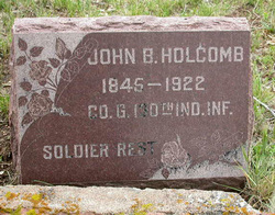
John B. Holcomb
| Birth | : | 27 Nov 1845 Wayne County, Indiana, USA |
| Death | : | 4 Jan 1922 Boulder County, Colorado, USA |
| Burial | : | Greenwood Cemetery, Greenwood, Doddridge County, USA |
| Coordinate | : | 39.2757988, -80.8880997 |
| Plot | : | Blk4MA Lot40 |
| Description | : | Longmont Ledger (Longmont, Boulder County) Jan 6, 1922 HOLCOMB--At his home above Lyons, Wednesday, January 4, 1922, John Holcomb, aged 76 years, 1 month and 7 days. "Uncle John" as he was familiarly called by many of his friends was an old timer in this section. He came to Colorado from Illinois thirty-seven years ago, first settling in Estes Park, and thirty-five years ago took up the homestead, about a mile above Lyons, on the South Fork road, where he has since made his home with his good wife. He was on e the most kindly old gentlemen we... Read More |
frequently asked questions (FAQ):
-
Where is John B. Holcomb's memorial?
John B. Holcomb's memorial is located at: Greenwood Cemetery, Greenwood, Doddridge County, USA.
-
When did John B. Holcomb death?
John B. Holcomb death on 4 Jan 1922 in Boulder County, Colorado, USA
-
Where are the coordinates of the John B. Holcomb's memorial?
Latitude: 39.2757988
Longitude: -80.8880997
Family Members:
Parent
Spouse
Siblings
Children
Flowers:


Nearby Cemetories:
1. Greenwood Cemetery
Greenwood, Doddridge County, USA
Coordinate: 39.2757988, -80.8880997
2. Duckworth Cemetery
Doddridge County, USA
Coordinate: 39.2766991, -80.8683014
3. Williamson Cemetery
Long Run, Doddridge County, USA
Coordinate: 39.2917720, -80.8751890
4. Todd Family Cemetery
Greenwood, Doddridge County, USA
Coordinate: 39.2896340, -80.8698030
5. Payne Family Cemetery
Greenwood, Doddridge County, USA
Coordinate: 39.2981890, -80.8773190
6. Sigler Cemetery
Long Run, Doddridge County, USA
Coordinate: 39.2923620, -80.8647390
7. Broadwater Cemetery
Ritchie County, USA
Coordinate: 39.2714005, -80.9207993
8. Jones Cemetery
Greenwood, Doddridge County, USA
Coordinate: 39.2531700, -80.8629700
9. Enoch Marsh Cemetery
Pennsboro, Ritchie County, USA
Coordinate: 39.2880200, -80.9302900
10. Oak Grove Church Cemetery
Ritchie County, USA
Coordinate: 39.3120995, -80.8871078
11. Buck Run Cemetery
Ritchie County, USA
Coordinate: 39.3078003, -80.9152985
12. Cabin Run Cemetery
West Union, Doddridge County, USA
Coordinate: 39.2361900, -80.8665000
13. Johnston Family Cemetery
West Union, Doddridge County, USA
Coordinate: 39.2593550, -80.8331870
14. Bartlett Cemetery
Ritchie County, USA
Coordinate: 39.3213528, -80.8994139
15. Sigler Cemetery
Pennsboro, Ritchie County, USA
Coordinate: 39.3088870, -80.9336500
16. Gnats Run Cemetery
Pennsboro, Ritchie County, USA
Coordinate: 39.3111700, -80.9355100
17. Cunningham Family Cemetery C-9
Pennsboro, Ritchie County, USA
Coordinate: 39.3150870, -80.9402460
18. Pigott Cemetery
Central Station, Doddridge County, USA
Coordinate: 39.3119011, -80.8311005
19. Ruley Cemetery
Central Station, Doddridge County, USA
Coordinate: 39.2731018, -80.8114014
20. Pennsboro First Methodist Cemetery
Pennsboro, Ritchie County, USA
Coordinate: 39.2838300, -80.9643100
21. E.U.B. Cemetery
Pennsboro, Ritchie County, USA
Coordinate: 39.2838500, -80.9647380
22. Saint Joseph Cemetery
Pennsboro, Ritchie County, USA
Coordinate: 39.2875786, -80.9665985
23. Pennsboro Presbyterian Cemetery
Pennsboro, Ritchie County, USA
Coordinate: 39.2860800, -80.9705600
24. Old Collins Cemetery
Pennsboro, Ritchie County, USA
Coordinate: 39.3226140, -80.9526570