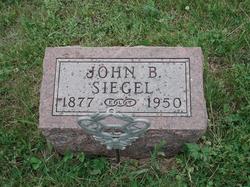
John B. Siegel
| Birth | : | 14 Sep 1877 Missouri, USA |
| Death | : | 5 Jun 1950 Excelsior Springs, Ray County, Missouri, USA |
| Burial | : | Mullica Hill Baptist Cemetery, Mullica Hill, Gloucester County, USA |
| Coordinate | : | 39.7337837, -75.2258377 |
| Description | : | Richmond Paper 6-8-1950 J. B. Siegel Succumbs, Joh Balsor Siegel, 72, died at his home east of Excelsior Springs on the old Lawson road at 11:15 a.m. Monday after being in failing health the past six months. Funeral services were held at 2 p.m. Wednesday at the Prichard chapel Excelsior and burial was in the Siegel cemetery. It was Mr. Siegel's last request that the Rev. Leon Clevenger officiate at his funeral. Mr. Siegel left a record of his illness during his last hours. He suffered a hemorrhage of the nose from 9 p.m. Sunday to... Read More |
frequently asked questions (FAQ):
-
Where is John B. Siegel's memorial?
John B. Siegel's memorial is located at: Mullica Hill Baptist Cemetery, Mullica Hill, Gloucester County, USA.
-
When did John B. Siegel death?
John B. Siegel death on 5 Jun 1950 in Excelsior Springs, Ray County, Missouri, USA
-
Where are the coordinates of the John B. Siegel's memorial?
Latitude: 39.7337837
Longitude: -75.2258377
Family Members:
Parent
Spouse
Siblings
Flowers:
Nearby Cemetories:
1. Mullica Hill Baptist Cemetery
Mullica Hill, Gloucester County, USA
Coordinate: 39.7337837, -75.2258377
2. Trinity United Methodist Church Cemetery
Mullica Hill, Gloucester County, USA
Coordinate: 39.7320251, -75.2273941
3. Mullica Hill Friends Cemetery
Mullica Hill, Gloucester County, USA
Coordinate: 39.7315712, -75.2244415
4. Saint Stephen's Episcopal Church Cemetery
Mullica Hill, Gloucester County, USA
Coordinate: 39.7388300, -75.2244400
5. Holy Name of Jesus Catholic Church Cemetery
Mullica Hill, Gloucester County, USA
Coordinate: 39.7411842, -75.2212982
6. Mount Calvary Baptist Church Cemetery
Mullica Hill, Gloucester County, USA
Coordinate: 39.7331009, -75.2371979
7. Richwood United Methodist Church Cemetery
Richwood, Gloucester County, USA
Coordinate: 39.7211100, -75.1667700
8. Mount Zion Methodist Church Cemetery
Barnsboro, Gloucester County, USA
Coordinate: 39.7547540, -75.1629530
9. Mickleton Meeting House Graveyard
Mickleton, Gloucester County, USA
Coordinate: 39.7910800, -75.2378900
10. Ferrell United Methodist Church Cemetery
Harrisonville, Gloucester County, USA
Coordinate: 39.6847725, -75.2669296
11. Solomons Graveyard
Wolfert, Gloucester County, USA
Coordinate: 39.7846985, -75.2636032
12. Saint Johns United Methodist Church Cemetery
Harrisonville, Gloucester County, USA
Coordinate: 39.6842500, -75.2666000
13. Driver Cemetery
Barnsboro, Gloucester County, USA
Coordinate: 39.7631000, -75.1554900
14. Lake Park Cemetery
Swedesboro, Gloucester County, USA
Coordinate: 39.7424393, -75.3076324
15. Eglington Cemetery
Clarksboro, Gloucester County, USA
Coordinate: 39.7980690, -75.2257462
16. Trinity Episcopal Churchyard
Swedesboro, Gloucester County, USA
Coordinate: 39.7511597, -75.3074951
17. Gates of Heaven Cemetery
Mount Royal, Gloucester County, USA
Coordinate: 39.7961006, -75.1967010
18. Trinity Episcopal Church New Cemetery
Swedesboro, Gloucester County, USA
Coordinate: 39.7522392, -75.3088837
19. Old Saint Josephs Cemetery
Swedesboro, Gloucester County, USA
Coordinate: 39.7521477, -75.3098068
20. Methodist Cemetery
Swedesboro, Gloucester County, USA
Coordinate: 39.7483990, -75.3114040
21. Zion United Methodist Church Cemetery
Clarksboro, Gloucester County, USA
Coordinate: 39.8030891, -75.2191696
22. Alms House Cemetery
Gloucester County, USA
Coordinate: 39.8029980, -75.2142200
23. Lippincott Cemetery
Clarksboro, Gloucester County, USA
Coordinate: 39.8032460, -75.2138660
24. Saint Joseph Cemetery
Swedesboro, Gloucester County, USA
Coordinate: 39.7669900, -75.3063500

