


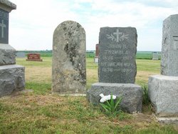
John Baptiste Tremblay
| Birth | : | 11 Sep 1837 |
| Death | : | 7 Feb 1918 Cloud County, Kansas, USA |
| Burial | : | Blue Creek Cemetery, Haviland, Paulding County, USA |
| Coordinate | : | 41.0385200, -84.6116100 |
| Description | : | J.B. Tremblay built the stone arch bridge at Rice, KS. |
frequently asked questions (FAQ):
-
Where is John Baptiste Tremblay's memorial?
John Baptiste Tremblay's memorial is located at: Blue Creek Cemetery, Haviland, Paulding County, USA.
-
When did John Baptiste Tremblay death?
John Baptiste Tremblay death on 7 Feb 1918 in Cloud County, Kansas, USA
-
Where are the coordinates of the John Baptiste Tremblay's memorial?
Latitude: 41.0385200
Longitude: -84.6116100
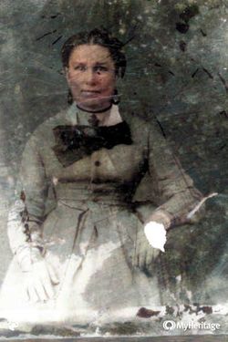
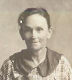
Family Members:
Spouse
Children
Flowers:


Nearby Cemetories:
1. Blue Creek Cemetery
Haviland, Paulding County, USA
Coordinate: 41.0385200, -84.6116100
2. Abbott Cemetery
Latty, Paulding County, USA
Coordinate: 41.0480090, -84.5966750
3. Dague Cemetery
Latty, Paulding County, USA
Coordinate: 41.0628260, -84.5802310
4. Pleasant View Cemetery
Paulding, Paulding County, USA
Coordinate: 41.0611000, -84.5699997
5. Apostolic Christian Church Cemetery
Latty, Paulding County, USA
Coordinate: 41.0760002, -84.5749969
6. Scott Cemetery
Scott, Van Wert County, USA
Coordinate: 40.9892006, -84.5950012
7. Saint Paul Cemetery
Paulding, Paulding County, USA
Coordinate: 41.1144943, -84.6296768
8. Snellenberger Cemetery
Paulding County, USA
Coordinate: 41.0936012, -84.6941986
9. Cooper Haines Cemetery
Paulding, Paulding County, USA
Coordinate: 41.1227989, -84.6222000
10. Hedges Cemetery
Paulding, Paulding County, USA
Coordinate: 41.0924988, -84.5194016
11. Wiltsie Cemetery
Payne, Paulding County, USA
Coordinate: 41.0894012, -84.7093964
12. Dealey Cemetery
Payne, Paulding County, USA
Coordinate: 41.0038986, -84.7221985
13. Mohr Cemetery
Van Wert, Van Wert County, USA
Coordinate: 40.9519005, -84.5614014
14. Saint Johns Cemetery
Payne, Paulding County, USA
Coordinate: 41.0689011, -84.7322006
15. McClure-Dowler Cemetery
Van Wert County, USA
Coordinate: 40.9421997, -84.5746994
16. Taylor Cemetery
Van Wert County, USA
Coordinate: 40.9421997, -84.5746994
17. Lehman Cemetery
Payne, Paulding County, USA
Coordinate: 41.0630989, -84.7442017
18. Live Oak Cemetery
Paulding, Paulding County, USA
Coordinate: 41.1422005, -84.5746994
19. Mount Zion Cemetery
Latty, Paulding County, USA
Coordinate: 41.0536003, -84.4582977
20. Brady-Finan Cemetery
Payne, Paulding County, USA
Coordinate: 41.0358910, -84.7666030
21. Sugar Ridge Cemetery
Convoy, Van Wert County, USA
Coordinate: 40.9382858, -84.6982346
22. County Home Cemetery
Paulding, Paulding County, USA
Coordinate: 41.1502762, -84.5541306
23. Mount Pleasant Cemetery
Van Wert County, USA
Coordinate: 40.9516983, -84.4961014
24. Dunkard Cemetery
Hoaglin, Van Wert County, USA
Coordinate: 40.9463997, -84.5006027