
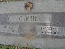
| Birth | : | 8 Feb 1862 Utah, USA |
| Death | : | 28 Oct 1932 Monterey, Monterey County, California, USA |
| Burial | : | El Carmelo Cemetery, Pacific Grove, Monterey County, USA |
| Coordinate | : | 36.6325836, -121.9319763 |
| Description | : | ****************************************** John Blythe Currie, son of John Currie and Elizabeth A "Betsy" Filcher, was born February 8, 1862 in Utah Territory and died October 28, 1932 in Monterey, California. He married Alice Edna Palmer. She was born in 1862 in Iowa and died in 1941 in Monterey, California. Children of John Currie and Alice Edna (Edna) Alice Palmer: * Mary Elsie 1885 - (Edward M Norton) * Edward Iber 1887 - 1889 * Sherman Franklin 1889 - 1892 * Ina Elizabeth 1891 - 1971 (George Henry Longmuir) * Wyland Leonard ... Read More |
frequently asked questions (FAQ):
-
Where is John Blythe Currie's memorial?
John Blythe Currie's memorial is located at: El Carmelo Cemetery, Pacific Grove, Monterey County, USA.
-
When did John Blythe Currie death?
John Blythe Currie death on 28 Oct 1932 in Monterey, Monterey County, California, USA
-
Where are the coordinates of the John Blythe Currie's memorial?
Latitude: 36.6325836
Longitude: -121.9319763
Family Members:
Parent
Spouse

Siblings
Children
Flowers:


Nearby Cemetories:
1. El Carmelo Cemetery
Pacific Grove, Monterey County, USA
Coordinate: 36.6325836, -121.9319763
2. Saint Mary's Episcopal Church Leslie Garden
Pacific Grove, Monterey County, USA
Coordinate: 36.6211200, -121.9145800
3. Steinbeck Estate Burial Site
Pacific Grove, Monterey County, USA
Coordinate: 36.6197319, -121.9080276
4. Presidio of Monterey Cemetery
Monterey, Monterey County, USA
Coordinate: 36.6058006, -121.9151306
5. Alexis Nino Burial Site
Monterey, Monterey County, USA
Coordinate: 36.6055565, -121.8955307
6. Mission San Carlos Cemetery
Monterey, Monterey County, USA
Coordinate: 36.5956078, -121.8904190
7. San Carlos Cemetery
Monterey, Monterey County, USA
Coordinate: 36.5951881, -121.8871460
8. Monterey City Cemetery
Monterey, Monterey County, USA
Coordinate: 36.5954475, -121.8845215
9. City of Carmel Memorials
Carmel-by-the-Sea, Monterey County, USA
Coordinate: 36.5552979, -121.9203339
10. Mission Memorial Park
Seaside, Monterey County, USA
Coordinate: 36.6191635, -121.8217926
11. Carmel Mission Cemetery
Carmel-by-the-Sea, Monterey County, USA
Coordinate: 36.5430603, -121.9199600
12. California Central Coast Veterans Cemetery
Seaside, Monterey County, USA
Coordinate: 36.6371900, -121.7963600
13. Carmelite Monastery Cemetery
Monterey, Monterey County, USA
Coordinate: 36.5231400, -121.9232635
14. Saint Dunstans Episcopal Church Columbarium
Carmel Valley, Monterey County, USA
Coordinate: 36.5197330, -121.8059160
15. Whitcher Cemetery
East Garrison, Monterey County, USA
Coordinate: 36.6501730, -121.7305270
16. Church of the Good Shepherd Cemetery
Salinas, Monterey County, USA
Coordinate: 36.5413990, -121.7260410
17. Castroville Public Cemetery
Moss Landing, Monterey County, USA
Coordinate: 36.7930145, -121.7851410
18. Calvary Catholic Cemetery
Salinas, Monterey County, USA
Coordinate: 36.6880341, -121.6818085
19. Saint Pauls Episcopal Church Columbarium
Salinas, Monterey County, USA
Coordinate: 36.6588430, -121.6558850
20. Stephen Norriss Gravesite
Monterey County, USA
Coordinate: 36.8214110, -121.7601080
21. Garden of Memories
Salinas, Monterey County, USA
Coordinate: 36.6565247, -121.6384125
22. Santa Rita Chapel and Cemetery
Salinas, Monterey County, USA
Coordinate: 36.7281303, -121.6565475
23. Saint Georges Episcopal Church Columbarium
Salinas, Monterey County, USA
Coordinate: 36.7062580, -121.6440980
24. Yamato Cemetery
Salinas, Monterey County, USA
Coordinate: 36.6552811, -121.6307297