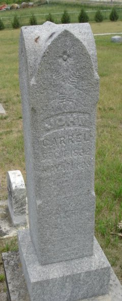
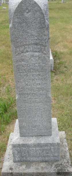
John Carrel
| Birth | : | 4 Dec 1832 Indiana, USA |
| Death | : | 17 May 1908 Boone County, Iowa, USA |
| Burial | : | Fair Haven Memorial Gardens, Moncton, Westmorland County, Canada |
| Coordinate | : | 46.0579200, -64.8671400 |
| Description | : | Civil War Veteran |
frequently asked questions (FAQ):
-
Where is John Carrel's memorial?
John Carrel's memorial is located at: Fair Haven Memorial Gardens, Moncton, Westmorland County, Canada.
-
When did John Carrel death?
John Carrel death on 17 May 1908 in Boone County, Iowa, USA
-
Where are the coordinates of the John Carrel's memorial?
Latitude: 46.0579200
Longitude: -64.8671400
Family Members:
Spouse
Children
Flowers:
"But whosoever drinketh of the water that I shall give him shall never thirst; but the water that I shall give him shall be in him a well of water springing up into everlasting life." -John 4:14
Left by Anonymous on 20 Sep 2006
John Carrel, one of the pioneer settlers of Boone county, died at his home in Madrid, Ia., on the morning of May 17, 1908. after an illness of much suffering which lasted about seven weeks. He was born near Bowling Green, Clay county, Indiana, in the year 1832 and was seventy six years old at the time of his death. His father, James Carrell, was a hatter by trade and in his early boyhood he acted as one of his father's assistants.In 1842 he moved with his parents to Iowa and the family settled in Jefferson county. This was four years before Iowa was admitted into the union. At that time, all the country west and north west of Jefferson county belonged to the Indians.By the terms of the treaty of October 11, 1842, a tract of land forty miles wide, situated west of the Black Hawk purchase was opened for settlement in the spring of 1843. At that date Mr. Carrel's father moved into Wapello County, tood a claim on which he lived five years. In the spring of 1848 the family moved to Boone county and took a claim two miles north west of Madrid on what is now the Frank Nelson farm. In 1850 this claim was disposed of and the family located near the timber north-west of Boone, and about this time Mr. Carrel became the owner of the land on which the new Johnson coal shaft is now being operated. Mr. Carrel has repeatedly said that he stood at his home and saw the flag spread to the breeze by the commissioners, who located the county seat of Boone county July 9, 1851. Mr. Carrel was united in marriage to Miss Amanda L. Lamb in 1852. Unto this union were born ten children, five sons and five daughters as follows: William Carrel of Holt, Missouri, Mary Kirk of Sherman City, Kansas, Sara Noland, Geroge Carrel and Marie Pike of Woodward, Ia., David Carrel of Holt, Missouri, Albert Carrel of Algona, Ia., Allie Davidson of Des Moines, Ia., Minnie Lucas, deceased June 16, 1906 and Thomas, who died in infancy.For many years Mr. Carrell owned a farm and lived in Cass township and there most of his children were born and raised. His first wife, Amanda L. Carrel died Jan 20, 1889, whose loss was much lamented by her family.Mr. Carrel was again united in marriage to Mrs. Maria Show, November 15, 1891, who survives him.In 1901 the farm in Cass township was sold and Mr. and Mrs. Carrel moved to Madrid where they have since resided.In early life Mr Carrel joined the United Brethren church. After moving to Madrid, Mr. and Mrs. Carrel united with the Christian church and their names are still on the church records.Mr. Carrel was the youngest of a large family of children. He lived in Iowa sixty-six years and saw it rise from its territorial form of government to be the leading one of the forty six states that compose the union.Wherever Mr. Carrel has lived he has proven himself to be an honest, upright, law abiding citizen. If he owed a debt he did not wait to be notified through the mails to come and settle but he voluntarily appeared before his creditors and settled without notice. In a controversy or difference of opinion with any of his fellow men, afterwards becoming convinced that he was in the wrong, he was always ready to right those wrongs. These are traits of character in fact, the foundation upon which good morals and good religion rest. Read less
Left by Anonymous on 22 Jul 2014
Left by Anonymous on 03 Oct 2015
Life is hard you my fill like giving up keep looking you my fine family..
Left by Anonymous on 23 Jan 2016
Left by Anonymous on 27 Nov 2010
Nearby Cemetories:
1. Fair Haven Memorial Gardens
Moncton, Westmorland County, Canada
Coordinate: 46.0579200, -64.8671400
2. Wilson Cemetery
Moncton, Westmorland County, Canada
Coordinate: 46.0585050, -64.8565850
3. Coverdale United Church Cemetery
Coverdale, Albert County, Canada
Coordinate: 46.0460230, -64.8652920
4. Alderwood Cemetery
Riverview, Albert County, Canada
Coordinate: 46.0474980, -64.8569820
5. Somers Family Cemetery
Moncton, Westmorland County, Canada
Coordinate: 46.0563100, -64.8870890
6. Greater Moncton Muslim Cemetery
Riverview, Albert County, Canada
Coordinate: 46.0461110, -64.8558050
7. Wesleyan Union Cemetery
Coverdale, Albert County, Canada
Coordinate: 46.0461660, -64.8827700
8. Milner Family Burial Plot
Moncton, Westmorland County, Canada
Coordinate: 46.0773490, -64.8112858
9. Cathédrale Notre-Dame-de-l'Assomption
Moncton, Westmorland County, Canada
Coordinate: 46.0908580, -64.7818820
10. Free Meeting House Cemetery
Moncton, Westmorland County, Canada
Coordinate: 46.0942200, -64.7748600
11. Berry Mills Cemetery
Berry Mills, Westmorland County, Canada
Coordinate: 46.1121000, -64.9389900
12. Horsman Cemetery
Moncton, Westmorland County, Canada
Coordinate: 46.1284000, -64.9111000
13. Steeves Mountain Cemetery
Steeves Mountain, Westmorland County, Canada
Coordinate: 46.0971940, -64.9645440
14. Steeves Mountain Cemetery Old
Steeves Mountain, Westmorland County, Canada
Coordinate: 46.0894450, -64.9703750
15. Elmwood Cemetery
Moncton, Westmorland County, Canada
Coordinate: 46.1097100, -64.7760900
16. Boundary Creek Cemetery
Moncton, Westmorland County, Canada
Coordinate: 46.0567580, -64.9884570
17. Shediac Road Roman Catholic Cemetery
Moncton, Westmorland County, Canada
Coordinate: 46.1072090, -64.7598880
18. Gorge Cemetery
Moncton, Westmorland County, Canada
Coordinate: 46.1514800, -64.8696600
19. Wilmot Memorial Cemetery
Lower Coverdale, Albert County, Canada
Coordinate: 46.0537760, -64.7271020
20. Our Lady of Calvary Cemetery
Dieppe, Westmorland County, Canada
Coordinate: 46.0800900, -64.7292300
21. Birchhill Cemetery
Berry Mills, Westmorland County, Canada
Coordinate: 46.1348500, -64.9593300
22. St. Anselme Parish Cemetery
Saint-Anselme, Westmorland County, Canada
Coordinate: 46.0707720, -64.7178080
23. Colpitts Community Cemetery
Colpitts Settlement, Albert County, Canada
Coordinate: 45.9736570, -64.9633240
24. Pine Hill Cemetery
Salisbury, Westmorland County, Canada
Coordinate: 46.0375710, -65.0198370


