
| Birth | : | 28 Oct 1926 Nuckolls County, Nebraska, USA |
| Death | : | 8 Nov 2003 Hastings, Adams County, Nebraska, USA |
| Burial | : | Nelson Cemetery, Nelson, Nuckolls County, USA |
| Coordinate | : | 40.2056084, -98.0791702 |
| Plot | : | Block 14, Lot 20, Grave 11 |
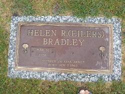
| Description | : | John Dale Eilers, the son of Otto and Ruby (Ray) Eilers, was born on October 28, 1926 on his parents farm east of Nelson, Nebraska. He passed away on November 8, 2003 at the Mary Lanning Hospital in Hastings, Nebraska at the age of 77 years and 10 days. John attended the Brown School east of Nelson. He farmed all his life in the Nelson are. He was preceded in death by his parents, Otto and Ruby. He is survived by a sister, Helen Bradley of Central City, Nebraska and two brothers, Robert and wife Mildred and Harold all... Read More |
frequently asked questions (FAQ):
-
Where is John Dale Eilers's memorial?
John Dale Eilers's memorial is located at: Nelson Cemetery, Nelson, Nuckolls County, USA.
-
When did John Dale Eilers death?
John Dale Eilers death on 8 Nov 2003 in Hastings, Adams County, Nebraska, USA
-
Where are the coordinates of the John Dale Eilers's memorial?
Latitude: 40.2056084
Longitude: -98.0791702
Family Members:
Parent

Siblings
Flowers:


Nearby Cemetories:
1. Nelson Cemetery
Nelson, Nuckolls County, USA
Coordinate: 40.2056084, -98.0791702
2. Oxbow Cemetery
Nelson, Nuckolls County, USA
Coordinate: 40.2560997, -98.0280991
3. Salem Cemetery
Nuckolls County, USA
Coordinate: 40.1255989, -98.0658035
4. Smith Cemetery
Nelson, Nuckolls County, USA
Coordinate: 40.3078003, -98.0567017
5. Nora Cemetery
Nora, Nuckolls County, USA
Coordinate: 40.1394005, -97.9705963
6. Union Cemetery
Nuckolls County, USA
Coordinate: 40.3146706, -98.1236877
7. Phil R Landon Gravesite
Angus, Nuckolls County, USA
Coordinate: 40.2703200, -97.9553200
8. Beulah Cemetery
Nuckolls County, USA
Coordinate: 40.1324997, -98.1986008
9. Sacred Heart Cemetery
Lawrence, Nuckolls County, USA
Coordinate: 40.2921982, -98.2268982
10. Saint Stephens Cemetery
Nuckolls County, USA
Coordinate: 40.2544899, -98.2562485
11. Assumption Church Cemetery
Deweese, Clay County, USA
Coordinate: 40.3507000, -98.1324000
12. Hannum Graves
Lawrence, Nuckolls County, USA
Coordinate: 40.3456500, -98.1766800
13. Oak Grove Cemetery
Oak, Nuckolls County, USA
Coordinate: 40.2326889, -97.8739471
14. Liberty Creek Cemetery
Nuckolls County, USA
Coordinate: 40.3361015, -98.2035980
15. Zion Cemetery
Webster County, USA
Coordinate: 40.2277985, -98.2921982
16. Beaver Creek Cemetery
Webster County, USA
Coordinate: 40.1617012, -98.2882996
17. Evergreen Cemetery
Superior, Nuckolls County, USA
Coordinate: 40.0374985, -98.0650024
18. Bostwick Cemetery
Bostwick, Nuckolls County, USA
Coordinate: 40.0536118, -98.1801071
19. Evergreen Cemetery
Lawrence, Nuckolls County, USA
Coordinate: 40.2922401, -98.2723236
20. Edgar Cemetery
Edgar, Clay County, USA
Coordinate: 40.3587200, -97.9700200
21. Spring Creek Cemetery
Ruskin, Nuckolls County, USA
Coordinate: 40.1258011, -97.8756027
22. Saint Martin-Loucky Cemetery
Deweese, Clay County, USA
Coordinate: 40.3652496, -98.1948624
23. Mount Zion Cemetery
Nuckolls County, USA
Coordinate: 40.1974983, -97.8397522
24. OBanion Cemetery
Blue Hill, Webster County, USA
Coordinate: 40.2850000, -98.3020000