
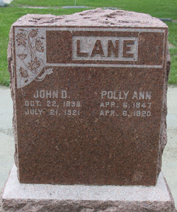
John Dustin Lane
| Birth | : | 22 Oct 1838 Texas County, Missouri, USA |
| Death | : | 21 Jul 1921 Ekalaka, Carter County, Montana, USA |
| Burial | : | Beaver Lodge Cemetery, Ekalaka, Carter County, USA |
| Coordinate | : | 45.8847008, -104.5522003 |
| Plot | : | Blk 20 - Row 2 - Lot 21 |
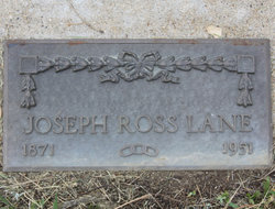
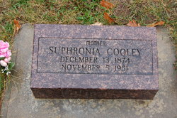
| Description | : | John Dustin Lane married Polly Ann Combs. John and Polly had children named Joseph Ross, Suphronia Margaret, Laura Mae, Allie Duzzle, John Denver and Nellie Pearl "Pearl" Lane. Powder River County Examiner (MT), 29 July 1921 83-Year-Old Man Burned to Death Near Ekalaka John D. Lane, age 83, and a pioneer resident of Ekalaka, burned to death at his home 10 miles northwest of Ekalaka, when his house was destroyed by fire. The aged man was asleep in the house when the fire started. His granddaughter was the only person on the place and her attempts to awaken him were unavailing due... Read More |
frequently asked questions (FAQ):
-
Where is John Dustin Lane's memorial?
John Dustin Lane's memorial is located at: Beaver Lodge Cemetery, Ekalaka, Carter County, USA.
-
When did John Dustin Lane death?
John Dustin Lane death on 21 Jul 1921 in Ekalaka, Carter County, Montana, USA
-
Where are the coordinates of the John Dustin Lane's memorial?
Latitude: 45.8847008
Longitude: -104.5522003
Family Members:
Spouse

Children
Flowers:


Nearby Cemetories:
1. Beaver Lodge Cemetery
Ekalaka, Carter County, USA
Coordinate: 45.8847008, -104.5522003
2. Russell Cemetery
Carter County, USA
Coordinate: 45.8292007, -104.4681015
3. Medicine Rock Church Cemetery
Ekalaka, Carter County, USA
Coordinate: 46.0545460, -104.4554010
4. Trenk Family Plot
Ekalaka, Carter County, USA
Coordinate: 45.7325000, -104.7083333
5. Willard Cemetery
Willard, Fallon County, USA
Coordinate: 46.1932000, -104.4123460
6. Lame Jones Cemetery
Plevna, Fallon County, USA
Coordinate: 46.2230988, -104.6181030
7. Ewalt Cemetery
Ridgeway, Carter County, USA
Coordinate: 45.4908333, -104.4786111
8. Pioneer Cemetery
Carter County, USA
Coordinate: 45.5859560, -104.1484850
9. Boothill Cemetery
Powder River County, USA
Coordinate: 45.7592010, -105.1239014
10. MacKenzie Family Cemetery
Custer County, USA
Coordinate: 46.1569500, -105.1448000
11. Saint John Cemetery
Baker, Fallon County, USA
Coordinate: 46.3563995, -104.2822037
12. Fairview Cemetery
Camp Crook, Harding County, USA
Coordinate: 45.5447006, -103.9972000
13. Saint Anthony Cemetery
Plevna, Fallon County, USA
Coordinate: 46.4042015, -104.5199966
14. Askin Family Cemetery
Fallon County, USA
Coordinate: 46.3806000, -104.2811000
15. Bonnievale Cemetery
Baker, Fallon County, USA
Coordinate: 46.3819008, -104.2791977
16. Peace Lutheran Cemetery
Plevna, Fallon County, USA
Coordinate: 46.4169006, -104.5294037
17. Community Union Cemetery
Plevna, Fallon County, USA
Coordinate: 46.4180984, -104.5289001
18. Alma Cemetery
Harding County, USA
Coordinate: 45.6469002, -103.8480988
19. Ladner Cemetery
Ladner, Harding County, USA
Coordinate: 45.8238983, -103.7694016
20. Fertile Prairie Cemetery
Fallon County, USA
Coordinate: 46.3396988, -104.0935974
21. Bringa Cemetery
Ladner, Harding County, USA
Coordinate: 45.7915570, -103.7575860
22. Knowlton Cemetery
Custer County, USA
Coordinate: 46.3210983, -105.0710983
23. Little Missouri Lutheran Cemetery
Carter County, USA
Coordinate: 45.4186000, -104.0820000
24. Capitol Cemetery
Capitol, Carter County, USA
Coordinate: 45.4294014, -104.0513992