

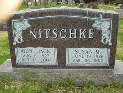
John Earl “Jack & Ralphie” Nitschke
| Birth | : | 6 Aug 1927 Ismay, Custer County, Montana, USA |
| Death | : | 12 Oct 2007 Miles City, Custer County, Montana, USA |
| Burial | : | Zion Lutheran Cemetery, Douds, Van Buren County, USA |
| Coordinate | : | 40.8563000, -92.0664000 |
| Description | : | John Earl Nitschke, 80, of Miles City, "Jack" as he was known by his many friends, or "Ralphie" as he was called by his four children, died at the Holy Rosary Medical Center on Friday, Oct. 12, 2007, after a short illness. In customary fashion he put up a valiant struggle, but the end came peacefully as he was surrounded by his family. Born Aug. 6, 1927, in Ismay, he was the son of Albert G. and Gladys Lombard Nitschke. He was the youngest of five siblings. He attended school in Ismay, graduating from high school after excelling in sports, in... Read More |
frequently asked questions (FAQ):
-
Where is John Earl “Jack & Ralphie” Nitschke's memorial?
John Earl “Jack & Ralphie” Nitschke's memorial is located at: Zion Lutheran Cemetery, Douds, Van Buren County, USA.
-
When did John Earl “Jack & Ralphie” Nitschke death?
John Earl “Jack & Ralphie” Nitschke death on 12 Oct 2007 in Miles City, Custer County, Montana, USA
-
Where are the coordinates of the John Earl “Jack & Ralphie” Nitschke's memorial?
Latitude: 40.8563000
Longitude: -92.0664000
Family Members:
Parent

Spouse
Siblings
Children
Flowers:


Nearby Cemetories:
1. Zion Lutheran Cemetery
Douds, Van Buren County, USA
Coordinate: 40.8563000, -92.0664000
2. Mount Moriah Cemetery
Douds, Van Buren County, USA
Coordinate: 40.8710000, -92.0860000
3. Leando Cemetery
Douds, Van Buren County, USA
Coordinate: 40.8269005, -92.0883026
4. White Chapel Cemetery
Birmingham, Van Buren County, USA
Coordinate: 40.8417015, -92.0203018
5. Boyer Family Cemetery
Leando, Van Buren County, USA
Coordinate: 40.8333560, -92.1112885
6. Bethel Cemetery
Birmingham, Van Buren County, USA
Coordinate: 40.8967018, -92.0056000
7. Winsell Cemetery
Fairfield, Jefferson County, USA
Coordinate: 40.9067001, -92.1247025
8. Passmore Cemetery
Van Buren County, USA
Coordinate: 40.8608017, -92.1549988
9. Roush Cemetery
Chequest Township, Van Buren County, USA
Coordinate: 40.7872009, -92.0755997
10. Iowaville Cemetery
Selma, Van Buren County, USA
Coordinate: 40.8861008, -92.1628036
11. Fell Cemetery
Libertyville, Jefferson County, USA
Coordinate: 40.9375000, -92.0772018
12. Valentine Cemetery
Keosauqua, Van Buren County, USA
Coordinate: 40.7743988, -92.0460968
13. Hem Cemetery
Davis County, USA
Coordinate: 40.8389015, -92.1785965
14. Hissem Cemetery
Selma, Van Buren County, USA
Coordinate: 40.8030784, -92.1587902
15. Kilbourne Cemetery
Van Buren County, USA
Coordinate: 40.8045000, -91.9705000
16. Cumberland Cemetery
Jefferson County, USA
Coordinate: 40.9248000, -91.9903000
17. Thompson Cemetery
Jefferson County, USA
Coordinate: 40.9155998, -91.9772034
18. Gilbert Cemetery
Kilbourn, Van Buren County, USA
Coordinate: 40.7916926, -91.9779510
19. Mathias Cemetery
Van Buren County, USA
Coordinate: 40.8031000, -92.1681000
20. United Presbyterian Cemetery
Birmingham, Van Buren County, USA
Coordinate: 40.8796000, -91.9438000
21. Methodist Episcopal Cemetery
Birmingham, Van Buren County, USA
Coordinate: 40.8788000, -91.9427000
22. Wilson Family Cemetery
Van Buren County, USA
Coordinate: 40.7951500, -91.9681000
23. Clinkinbeard Family Cemetery
Libertyville, Jefferson County, USA
Coordinate: 40.9083300, -91.9583300
24. Cook Cemetery
Keosauqua, Van Buren County, USA
Coordinate: 40.7839000, -91.9778000