
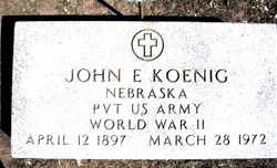
John Edward Koenig
| Birth | : | 12 Apr 1897 Polk County, Nebraska, USA |
| Death | : | 28 Mar 1972 Grand Island, Hall County, Nebraska, USA |
| Burial | : | Entiat Cemetery, Entiat, Chelan County, USA |
| Coordinate | : | 47.6755981, -120.3043976 |
| Description | : | http://www.rootsweb.ancestry.com/~neplatte/vitals/vitals1972.html The Columbus Telegram, March 28, 1972 KOENIG--Friday rites set for John Koenig John E. Koenig, 74, of 3081 (?) 20th Street, died Tuesday at the Veterans Hospital in Grand Island. He had been ill since January. Scripture service will be held at 7 p.m. Thursday at McKown Funeral Home where the body will lie in state, and a 10 a.m. Friday service will be conducted by Rev. Regis Watts at St. Bonaventure Catholic Church. Memorial Mass at church will be 9 a.m. Monday. An Army veteran of World... Read More |
frequently asked questions (FAQ):
-
Where is John Edward Koenig's memorial?
John Edward Koenig's memorial is located at: Entiat Cemetery, Entiat, Chelan County, USA.
-
When did John Edward Koenig death?
John Edward Koenig death on 28 Mar 1972 in Grand Island, Hall County, Nebraska, USA
-
Where are the coordinates of the John Edward Koenig's memorial?
Latitude: 47.6755981
Longitude: -120.3043976
Family Members:
Parent

Siblings
Flowers:


Nearby Cemetories:
1. Entiat Cemetery
Entiat, Chelan County, USA
Coordinate: 47.6755981, -120.3043976
2. Orondo Community Cemetery
Orondo, Douglas County, USA
Coordinate: 47.6486015, -120.2136002
3. Brays Landing Cemetery
Douglas County, USA
Coordinate: 47.7364120, -120.1704660
4. Waterville Cemetery
Waterville, Douglas County, USA
Coordinate: 47.6418500, -120.0685940
5. Gate of Heaven Catholic Cemetery
Waterville, Douglas County, USA
Coordinate: 47.6382100, -120.0671690
6. Ballard Family Cemetery
Stayman, Chelan County, USA
Coordinate: 47.7811100, -120.1133300
7. Kummer Cemetery
Waterville, Douglas County, USA
Coordinate: 47.6559000, -120.0332000
8. Badger Mountain Cemetery
Douglas County, USA
Coordinate: 47.5063000, -120.1938000
9. Badger Mountain View Cemetery
Douglas County, USA
Coordinate: 47.6088000, -120.0476000
10. Old Missionary Indian Cemetery
Cashmere, Chelan County, USA
Coordinate: 47.5166000, -120.4493000
11. Sunnyslope Church of the Brethren Cemetery
Sunnyslope, Chelan County, USA
Coordinate: 47.4784431, -120.3465576
12. Cashmere Cemetery
Cashmere, Chelan County, USA
Coordinate: 47.5186996, -120.4869003
13. Valley View Cemetery
Douglas County, USA
Coordinate: 47.4730988, -120.2981033
14. Brisky Treadwell Cemetery
Cashmere, Chelan County, USA
Coordinate: 47.5149770, -120.4955480
15. George W. Parrish Gravesite
Monitor, Chelan County, USA
Coordinate: 47.4688600, -120.4256400
16. Peshastin Cemetery
Peshastin, Chelan County, USA
Coordinate: 47.5828018, -120.6074982
17. Wenatchee City Cemetery
Wenatchee, Chelan County, USA
Coordinate: 47.4510994, -120.3463974
18. Manson Indian Cemetery
Manson, Chelan County, USA
Coordinate: 47.8800000, -120.1300000
19. Douglas Lutheran Cemetery
Douglas County, USA
Coordinate: 47.6189003, -119.9614029
20. Hillcrest Haven of Rest Cemetery
Plain, Chelan County, USA
Coordinate: 47.7832000, -120.6203000
21. Leavenworth North Road Cemetery
Leavenworth, Chelan County, USA
Coordinate: 47.6089410, -120.6458040
22. Stutesman Family Cemetery
Leavenworth, Chelan County, USA
Coordinate: 47.6217100, -120.6508400
23. Hamilton Cemetery
East Wenatchee, Douglas County, USA
Coordinate: 47.4336014, -120.2482986
24. Jack Burpee Gravesite
Leavenworth, Chelan County, USA
Coordinate: 47.5947792, -120.6562080