
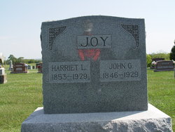
John Gray Joy
| Birth | : | 7 Feb 1846 Ray County, Missouri, USA |
| Death | : | 22 Oct 1929 Grape Grove Township, Ray County, Missouri, USA |
| Burial | : | Goulburn Old Cemetery, Goulburn, Goulburn Mulwaree Council, Australia |
| Coordinate | : | -34.7444690, 149.7378160 |
| Description | : | MO Death Cert # 34807 Father = John W. Joy/England Mother = Mary Macey Widow = Harriet L. Joy Informant = Mary Joy Occupation = Farmer COD = Uremic Poison |
frequently asked questions (FAQ):
-
Where is John Gray Joy's memorial?
John Gray Joy's memorial is located at: Goulburn Old Cemetery, Goulburn, Goulburn Mulwaree Council, Australia.
-
When did John Gray Joy death?
John Gray Joy death on 22 Oct 1929 in Grape Grove Township, Ray County, Missouri, USA
-
Where are the coordinates of the John Gray Joy's memorial?
Latitude: -34.7444690
Longitude: 149.7378160
Family Members:
Parent
Spouse

Siblings
Children
Flowers:


Nearby Cemetories:
1. Goulburn Old Cemetery
Goulburn, Goulburn Mulwaree Council, Australia
Coordinate: -34.7444690, 149.7378160
2. Saint Saviours Anglican Cemetery
Goulburn, Goulburn Mulwaree Council, Australia
Coordinate: -34.7406960, 149.7432970
3. Goulburn Jewish Cemetery
Goulburn, Goulburn Mulwaree Council, Australia
Coordinate: -34.7551950, 149.7433550
4. Goulburn General Cemetery
Goulburn, Goulburn Mulwaree Council, Australia
Coordinate: -34.7442800, 149.7541200
5. Saint Saviours Cathedral Churchyard
Goulburn, Goulburn Mulwaree Council, Australia
Coordinate: -34.7531700, 149.7159700
6. Kenmore Roman Catholic Cemetery
Goulburn, Goulburn Mulwaree Council, Australia
Coordinate: -34.7244290, 149.7319710
7. Sts Peter & Paul Old Cathedral
Goulburn, Goulburn Mulwaree Council, Australia
Coordinate: -34.7556340, 149.7150370
8. Kenmore Mental Hospital Cemetery
Kenmore, Goulburn Mulwaree Council, Australia
Coordinate: -34.7187600, 149.7554470
9. St Patricks College (now Trinity Catholic College)
Goulburn, Goulburn Mulwaree Council, Australia
Coordinate: -34.7492240, 149.6969980
10. St. Andrew's Cemetery
Tirrannaville, Goulburn Mulwaree Council, Australia
Coordinate: -34.8181980, 149.6833340
11. Thurlow Methodist Church
Baw Baw, Goulburn Mulwaree Council, Australia
Coordinate: -34.7086590, 149.6179610
12. St Johns Anglican Churchyard
Towrang, Goulburn Mulwaree Council, Australia
Coordinate: -34.6956160, 149.8507090
13. Merrilla Cemetery
Goulburn, Goulburn Mulwaree Council, Australia
Coordinate: -34.7486220, 149.5993750
14. St James Anglican Cemetery
Pomeroy, Goulburn Mulwaree Council, Australia
Coordinate: -34.7488140, 149.5993110
15. St. Mary Cemetery
Yarra, Goulburn Mulwaree Council, Australia
Coordinate: -34.7973480, 149.6142910
16. Merrilla Methodist Cemetery
Merrilla, Goulburn Mulwaree Council, Australia
Coordinate: -34.7428100, 149.5785790
17. Komungla General Cemetery
Komungla, Goulburn Mulwaree Council, Australia
Coordinate: -34.8784540, 149.6404940
18. Mummell Catholic cemetery
Mummel, Goulburn Mulwaree Council, Australia
Coordinate: -34.6680260, 149.5499320
19. Murrel Cemetery
Mummel, Goulburn Mulwaree Council, Australia
Coordinate: -34.6680600, 149.5498400
20. Parkesbourne Methodist Cemetery
Parkesbourne, Goulburn Mulwaree Council, Australia
Coordinate: -34.7588220, 149.5222900
21. Marulan Anglican Cemetery
Marulan, Goulburn Mulwaree Council, Australia
Coordinate: -34.7318400, 149.9817200
22. Christ Church Anglican Churchyard
Bungonia, Goulburn Mulwaree Council, Australia
Coordinate: -34.8590005, 149.9432472
23. Marulan Catholic Cemetery
Marulan, Goulburn Mulwaree Council, Australia
Coordinate: -34.7281400, 149.9862120
24. Bungonia Cemetery
Bungonia, Goulburn Mulwaree Council, Australia
Coordinate: -34.8632150, 149.9422700