
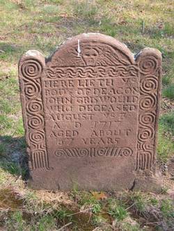

John Griswold
| Birth | : | 1 Aug 1652 Connecticut, USA |
| Death | : | 3 Aug 1717 Killingworth, Middlesex County, Connecticut, USA |
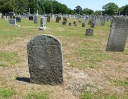
| Burial | : | Valley Cemetery, Valley, Stevens County, USA |
| Coordinate | : | 48.1790600, -117.7235500 |
| Plot | : | Poss. Next to Bathsheba Tombstone |
| Description | : | John Griswold (son of Edward Griswold) was born 01 Aug 1652 in bpt.recorded @ Windsor,Hartford,CT, and died 03 Aug 1717 in Killingworth,Middlesex,CT. Notes for John Griswold: from: "Griswold Family" vol II--pg. 32 John was a farmer; prominent & leading citizen. Deacon for many years. Served on important civil committees. Deputy 1690. Captain 1712. Served in the Narragansett War. The town granted him six acres for his services in the Indian Wars. Died 7 Burial in congregational cemetery, Clinton,CT. It is possible that Bathsheba is buried in vacant space next to his tombstone. All children recorded in Killingworth records Will--State Library, Hartford,CT written: 6 Jun... Read More |
frequently asked questions (FAQ):
-
Where is John Griswold's memorial?
John Griswold's memorial is located at: Valley Cemetery, Valley, Stevens County, USA.
-
When did John Griswold death?
John Griswold death on 3 Aug 1717 in Killingworth, Middlesex County, Connecticut, USA
-
Where are the coordinates of the John Griswold's memorial?
Latitude: 48.1790600
Longitude: -117.7235500
Family Members:
Parent

Spouse

Siblings
Children
Flowers:


Nearby Cemetories:
1. Valley Cemetery
Valley, Stevens County, USA
Coordinate: 48.1790600, -117.7235500
2. Old Valley Indian Cemetery
Valley, Stevens County, USA
Coordinate: 48.1977700, -117.7402800
3. Pine Grove Mennonite Church Cemetery
Valley, Stevens County, USA
Coordinate: 48.1506844, -117.7037888
4. Saint Josephs Cemetery
Stevens County, USA
Coordinate: 48.1523330, -117.6883330
5. Chewelah Memorial Park
Chewelah, Stevens County, USA
Coordinate: 48.2592010, -117.7127991
6. Indian Cemetery
Chewelah, Stevens County, USA
Coordinate: 48.2600300, -117.7102400
7. Forest Center Cemetery
Springdale, Stevens County, USA
Coordinate: 48.0937614, -117.7685471
8. Chewelah Pioneer Cemetery
Chewelah, Stevens County, USA
Coordinate: 48.2802330, -117.6939740
9. Saint Mary of the Rosary Cemetery
Chewelah, Stevens County, USA
Coordinate: 48.2813940, -117.6938990
10. Springdale Cemetery
Springdale, Stevens County, USA
Coordinate: 48.0419000, -117.7475200
11. Loon Lake Community Cemetery
Loon Lake, Stevens County, USA
Coordinate: 48.0550003, -117.6141663
12. Addy Cemetery
Addy, Stevens County, USA
Coordinate: 48.3442688, -117.8465576
13. Summit Valley Cemetery
Addy, Stevens County, USA
Coordinate: 48.3086014, -117.9424973
14. Tanger-Skeels Cemetery
Stevens County, USA
Coordinate: 48.3699400, -117.8522400
15. Zion Hill Cemetery
Deer Park, Spokane County, USA
Coordinate: 48.0024986, -117.5297012
16. Moses Cemetery
Ford, Stevens County, USA
Coordinate: 47.9365800, -117.8311500
17. Pleasant View Cemetery
Ford, Stevens County, USA
Coordinate: 47.9267006, -117.7755966
18. Calispell Cemetery
Pend Oreille County, USA
Coordinate: 48.2888300, -117.3644000
19. Greenwood Cemetery
Hunters, Stevens County, USA
Coordinate: 48.1263885, -118.1127777
20. Hubert Cemetery
Ford, Stevens County, USA
Coordinate: 47.9188881, -117.8033295
21. Saint Mary Catholic Cemetery
Deer Park, Spokane County, USA
Coordinate: 47.9700012, -117.4700012
22. Woodland Cemetery
Deer Park, Spokane County, USA
Coordinate: 47.9557991, -117.4918976
23. Williams Valley Hillside Cemetery
Stevens County, USA
Coordinate: 47.9211006, -117.5836029
24. Stranger Creek Cemetery
Daisy, Stevens County, USA
Coordinate: 48.3297005, -118.0832977