

Walter Griswold
| Birth | : | 7 Mar 1700 Killingworth, Middlesex County, Connecticut, USA |
| Death | : | 16 Oct 1745 Old Saybrook, Middlesex County, Connecticut, USA |
| Burial | : | Riverside Cemetery, Lincoln, Grafton County, USA |
| Coordinate | : | 44.0505900, -71.6856100 |
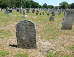
| Description | : | The listing for this grave in the 1934 cemetery reading found in the Hale Collection (CT State Library) shows the year of his death only as 17__, indicating also that the "very old fieldstone" was "eroded". His birthdate is taken from Savage (Vol. 2). Some listings show him born in 1699, which is consistent with the Savage 1700 listing in the "Old Style" of dating. CT Vital Records through 1870 (Barbour Collection) Vol. 2, p. 72, indicate he and Sarah WRIGHT married on Oct 24, 1723. The same source shows the couple had at least one son, Walter Price GRISWOLD,... Read More |
frequently asked questions (FAQ):
-
Where is Walter Griswold's memorial?
Walter Griswold's memorial is located at: Riverside Cemetery, Lincoln, Grafton County, USA.
-
When did Walter Griswold death?
Walter Griswold death on 16 Oct 1745 in Old Saybrook, Middlesex County, Connecticut, USA
-
Where are the coordinates of the Walter Griswold's memorial?
Latitude: 44.0505900
Longitude: -71.6856100
Family Members:
Parent

Siblings
Children
Flowers:


Nearby Cemetories:
1. Riverside Cemetery
Lincoln, Grafton County, USA
Coordinate: 44.0505900, -71.6856100
2. Clark's Trading Post Animal Cemetery
Lincoln, Grafton County, USA
Coordinate: 44.0483740, -71.6862130
3. Hanson Farm Road Cemetery
Lincoln, Grafton County, USA
Coordinate: 44.0663890, -71.6869440
4. Jackman Cemetery
Grafton County, USA
Coordinate: 44.0322220, -71.6969440
5. Parker Cemetery
Woodstock, Grafton County, USA
Coordinate: 44.0193000, -71.6839700
6. Woodstock Cemetery
Woodstock, Grafton County, USA
Coordinate: 43.9827600, -71.6827500
7. Wildcat Cemetery
Thornton, Grafton County, USA
Coordinate: 43.9909710, -71.6391440
8. Easton Cemetery
Easton, Grafton County, USA
Coordinate: 44.1375000, -71.7805560
9. Kinsman Cemetery
Easton, Grafton County, USA
Coordinate: 44.1374900, -71.7808700
10. Brown Farmstead Cemetery
Benton, Grafton County, USA
Coordinate: 44.0778000, -71.8420830
11. Pine Grove Cemetery
Thornton, Grafton County, USA
Coordinate: 43.9060100, -71.6689000
12. East Cemetery
Benton, Grafton County, USA
Coordinate: 44.0985985, -71.8846970
13. West Thornton Cemetery
Thornton, Grafton County, USA
Coordinate: 43.8997200, -71.6805600
14. Willow Cemetery
Franconia, Grafton County, USA
Coordinate: 44.1968994, -71.7530975
15. Waterville Valley Cemetery
Waterville Valley, Grafton County, USA
Coordinate: 43.9634670, -71.5087000
16. Yeaton Cemetery
Thornton, Grafton County, USA
Coordinate: 43.8963800, -71.6794500
17. Blake Mountain Cemetery
Thornton, Grafton County, USA
Coordinate: 43.8963600, -71.6794200
18. High Street Cemetery
Glencliff, Grafton County, USA
Coordinate: 43.9851100, -71.8913900
19. West Cemetery
Benton, Grafton County, USA
Coordinate: 44.1033700, -71.9014000
20. Noyes Cemetery
Landaff, Grafton County, USA
Coordinate: 44.1830560, -71.8286110
21. Packard Graveyard
Thornton, Grafton County, USA
Coordinate: 43.8971540, -71.5845930
22. Mad River Cemetery
Thornton, Grafton County, USA
Coordinate: 43.8833670, -71.6077500
23. Avery Cemetery
Ellsworth, Grafton County, USA
Coordinate: 43.8805600, -71.7511200
24. Elmwood Cemetery
Franconia, Grafton County, USA
Coordinate: 44.2219009, -71.7474976