
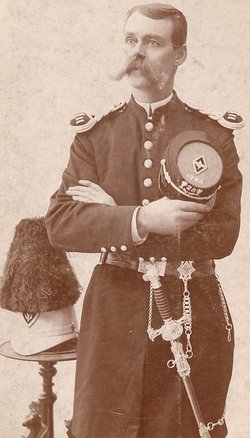
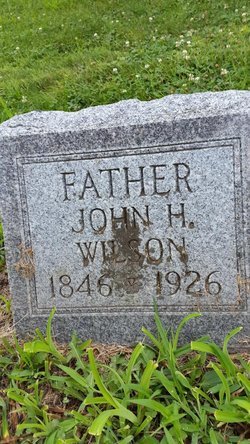
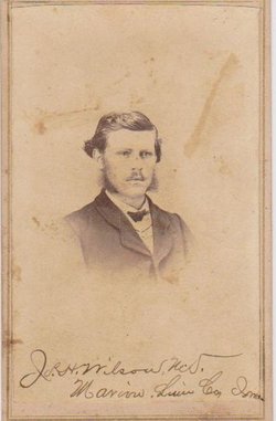
John Harned Wilson
| Birth | : | 23 Mar 1846 New Philadelphia, Washington County, Indiana, USA |
| Death | : | 11 Dec 1926 Monrovia, Los Angeles County, California, USA |
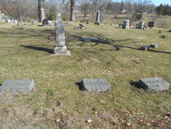
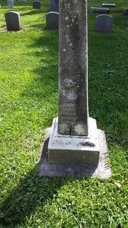
| Burial | : | Saint Francis Xavier Cemetery, Seward, Stafford County, USA |
| Coordinate | : | 38.2038994, -98.8193970 |
| Plot | : | Town Lot 7, Lot 13, Space 6 |
| Description | : | John Harned Wilson, the second son of John McClure Wilson and Elizabeth Harned, was born March 23, 1846 in New Philadelphia, Washington County, Indiana. His mother, whose family were members of the Blue River Friends community, died about three weeks after John's birth. Whether her death was childbirth related, we can only surmise. In 1853 John H. Wilson, his father and step-mother, John M. and Polly (Beem) Woody Wilson; his step-brothers, Richard L. and Augusta A. Woody; his brother, Joseph H. and his younger half-brother, William W., moved from Indiana to Marion, Linn County, Iowa. His father... Read More |
frequently asked questions (FAQ):
-
Where is John Harned Wilson's memorial?
John Harned Wilson's memorial is located at: Saint Francis Xavier Cemetery, Seward, Stafford County, USA.
-
When did John Harned Wilson death?
John Harned Wilson death on 11 Dec 1926 in Monrovia, Los Angeles County, California, USA
-
Where are the coordinates of the John Harned Wilson's memorial?
Latitude: 38.2038994
Longitude: -98.8193970
Family Members:
Parent
Spouse
Siblings
Children

Flowers:


Nearby Cemetories:
1. Saint Francis Xavier Cemetery
Seward, Stafford County, USA
Coordinate: 38.2038994, -98.8193970
2. Eden Valley Cemetery
Seward, Stafford County, USA
Coordinate: 38.2182999, -98.7853012
3. Pleasant Ridge Cemetery
Radium, Stafford County, USA
Coordinate: 38.2475014, -98.8758011
4. Point View Cemetery
Pawnee County, USA
Coordinate: 38.1306000, -98.9131012
5. Fertig Cemetery
Pawnee County, USA
Coordinate: 38.1458015, -98.9492035
6. Dundee Valley Cemetery
Great Bend, Barton County, USA
Coordinate: 38.3125130, -98.8778980
7. Peace United Church of Christ Cemetery
Hudson, Stafford County, USA
Coordinate: 38.1591988, -98.6579971
8. Pawnee Rock State Historic Site
Pawnee Rock, Barton County, USA
Coordinate: 38.2721800, -98.9815300
9. Pawnee Rock Cemetery
Pawnee Rock, Barton County, USA
Coordinate: 38.2771988, -98.9858017
10. Salem Cemetery
Hudson, Stafford County, USA
Coordinate: 38.1514015, -98.6399994
11. Bergthal Mennonite Cemetery
Pawnee Rock, Barton County, USA
Coordinate: 38.3053017, -98.9772034
12. Trinity Cemetery
Hudson, Stafford County, USA
Coordinate: 38.1048600, -98.6560400
13. Dominican Sisters Resurrection Cemetery
Barton County, USA
Coordinate: 38.3665090, -98.7886990
14. Great Bend Cemetery
Great Bend, Barton County, USA
Coordinate: 38.3680992, -98.7996979
15. Great Bend Cemetery North
Barton County, USA
Coordinate: 38.3761800, -98.8019840
16. Everett Cemetery
Barton County, USA
Coordinate: 38.3767014, -98.9092026
17. Devore Family Cemetery
St. John, Stafford County, USA
Coordinate: 38.0141200, -98.7947700
18. Fairview Park Cemetery
St. John, Stafford County, USA
Coordinate: 38.0078380, -98.7456540
19. Feldhut Cemetery
Hudson, Stafford County, USA
Coordinate: 38.0415000, -98.6372600
20. Clarence Township Cemetery
Heizer, Barton County, USA
Coordinate: 38.4052590, -98.9230600
21. Saint Pauls Lutheran Cemetery
Albert, Barton County, USA
Coordinate: 38.3770000, -99.0005900
22. Golden Belt Memorial Park
Great Bend, Barton County, USA
Coordinate: 38.4336014, -98.7850037
23. Hillcrest Memorial Park
Great Bend, Barton County, USA
Coordinate: 38.4361000, -98.7782974
24. Strobel Cemetery
Stafford, Stafford County, USA
Coordinate: 38.0414009, -98.6007996