
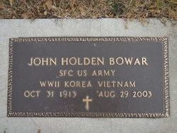

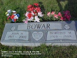
John Holden Bowar
| Birth | : | 31 Oct 1913 Pierre, Hughes County, South Dakota, USA |
| Death | : | 29 Aug 2003 |
| Burial | : | Temuka Cemetery, Temuka, Timaru District, New Zealand |
| Coordinate | : | -44.2499010, 171.3014390 |
| Inscription | : | SFC US ARMY WWII KOREA VIETNAM |
| Description | : | John Holden Bowar 1913 2003 John Holden Bowar, 89, died Friday, Aug. 29, 2003. A memorial service with military honors will be held Monday Oct. 6, 2003, at Reck Funeral Home in Miller with Brother Bill Myers officiating. Interment will be in the St. Lawrence Cemetery. John Holden Bowar was born October 31, 1913 to William Matthew and Mary Lucinda Bowar at Pierre, S.D. He graduated from Wessington Springs High School and Dakota Wesleyan College, Mitchell. He served in the South Dakota National Guard. In 1939, he enlisted in the United... Read More |
frequently asked questions (FAQ):
-
Where is John Holden Bowar's memorial?
John Holden Bowar's memorial is located at: Temuka Cemetery, Temuka, Timaru District, New Zealand.
-
When did John Holden Bowar death?
John Holden Bowar death on 29 Aug 2003 in
-
Where are the coordinates of the John Holden Bowar's memorial?
Latitude: -44.2499010
Longitude: 171.3014390
Family Members:
Spouse
Children

Flowers:


Nearby Cemetories:
1. Temuka Cemetery
Temuka, Timaru District, New Zealand
Coordinate: -44.2499010, 171.3014390
2. Whareki Cemetery
Temuka, Timaru District, New Zealand
Coordinate: -44.2558600, 171.2734500
3. Pleasant Point Cemetery
Pleasant Point, Timaru District, New Zealand
Coordinate: -44.2615490, 171.1237320
4. Geraldine Cemetery
Geraldine, Timaru District, New Zealand
Coordinate: -44.0982600, 171.2407000
5. Timaru Cemetery
Timaru, Timaru District, New Zealand
Coordinate: -44.4122320, 171.2574270
6. Saint Aidan's Churchyard
Geraldine, Timaru District, New Zealand
Coordinate: -44.1544420, 171.0980340
7. St. Anne's Churchyard
Geraldine, Timaru District, New Zealand
Coordinate: -44.0836111, 171.1994444
8. Salisbury Park Crematorium
Timaru, Timaru District, New Zealand
Coordinate: -44.4292400, 171.2080200
9. Woodbury Cemetery
Woodbury, Timaru District, New Zealand
Coordinate: -44.0360900, 171.2127000
10. Pareora West Cemetery
Pareora West, Timaru District, New Zealand
Coordinate: -44.4383120, 171.1343000
11. St David’s Anglican Churchyard
Mackenzie District, New Zealand
Coordinate: -44.1706380, 170.9887810
12. Burnett Family Cemetery
Cave, Timaru District, New Zealand
Coordinate: -44.3156830, 170.9457270
13. Arundel Cemetery
Arundel, Timaru District, New Zealand
Coordinate: -43.9785690, 171.2838900
14. Albury Cemetery
Albury, Mackenzie District, New Zealand
Coordinate: -44.2371220, 170.8736570
15. Hinds Cemetery
Hinds, Ashburton District, New Zealand
Coordinate: -44.0075580, 171.5735400
16. St. Mary's Church Cemetery
Esk Valley, Waimate District, New Zealand
Coordinate: -44.5244000, 171.0836000
17. Cracroft Cemetery
Ruapuna, Ashburton District, New Zealand
Coordinate: -43.9341900, 171.2989500
18. Otaio Cemetery
Otaio, Waimate District, New Zealand
Coordinate: -44.5535220, 171.1790260
19. Longbeach Estate Chapel
Longbeach, Ashburton District, New Zealand
Coordinate: -44.0941090, 171.6884504
20. Windermere Cemetery
Windermere, Ashburton District, New Zealand
Coordinate: -43.9874945, 171.6232358
21. Waterton Cemetery
Eiffelton, Ashburton District, New Zealand
Coordinate: -44.0640000, 171.7260000
22. Fairlie Cemetery
Fairlie, Mackenzie District, New Zealand
Coordinate: -44.1075700, 170.8301500
23. Winslow Cemetery
Winslow, Ashburton District, New Zealand
Coordinate: -43.9576290, 171.6522810
24. Ruapuna Cemetery
Ruapuna, Ashburton District, New Zealand
Coordinate: -43.8436110, 171.3680400