John Hoop
| Birth | : | 9 Mar 1836 Edgar County, Illinois, USA |
| Death | : | 24 Oct 1909 Boone County, Iowa, USA |
| Burial | : | Boone County Poor Farm Cemetery, Boone County, USA |
| Coordinate | : | 42.1591100, -93.9159000 |
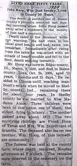
| Description | : | Boone County Democrat October 29, 1909 John Hoop, an old resident of the county, dropped dead suddenly about 7:30 o’clock Sunday morning at the county farm. Death was caused by heart failure. He had just finished breakfast and started to walk to the men’s quarters, when he suddenly fell to the ground and when assistance reached him he was dead. He was taken to the farm from Madrid some time ago for proper care and treatment. Brief funeral services were held Monday afternoon and the remains interred in the cemetery at the farm. ∼Buried on .family... Read More |
frequently asked questions (FAQ):
-
Where is John Hoop's memorial?
John Hoop's memorial is located at: Boone County Poor Farm Cemetery, Boone County, USA.
-
When did John Hoop death?
John Hoop death on 24 Oct 1909 in Boone County, Iowa, USA
-
Where are the coordinates of the John Hoop's memorial?
Latitude: 42.1591100
Longitude: -93.9159000
Family Members:
Parent
Siblings
Flowers:
Nearby Cemetories:
1. Mineral Ridge Cemetery
Ridgeport, Boone County, USA
Coordinate: 42.1749992, -93.9266968
2. White Cemetery
Boone County, USA
Coordinate: 42.1777992, -93.9636002
3. Schlicht Cemetery
Fraser, Boone County, USA
Coordinate: 42.1444200, -93.9780100
4. Hickory Grove Cemetery
Boone County, USA
Coordinate: 42.1074982, -93.9507980
5. Leininger Cemetery
Boone County, USA
Coordinate: 42.1492004, -93.8356018
6. Bass Point Cemetery
Boone, Boone County, USA
Coordinate: 42.0992012, -93.8957977
7. Buckley Cemetery
Boone, Boone County, USA
Coordinate: 42.0999810, -93.9418960
8. Runyan Cemetery
Pilot Mound, Boone County, USA
Coordinate: 42.1749992, -94.0015030
9. Linn Cemetery
Pilot Mound, Boone County, USA
Coordinate: 42.2045330, -93.9970230
10. South Marion Cemetery
Stratford, Hamilton County, USA
Coordinate: 42.2327995, -93.8735962
11. Saint Paul Lutheran Cemetery
Boone, Boone County, USA
Coordinate: 42.1700000, -93.8070000
12. Pilot Mound Cemetery
Pilot Mound, Boone County, USA
Coordinate: 42.1636200, -94.0282600
13. Hardin Township Cemetery
Hardin Township, Webster County, USA
Coordinate: 42.2411003, -93.9708023
14. Bluff Creek Cemetery
Boone, Boone County, USA
Coordinate: 42.0774994, -93.9796982
15. Linwood Park Cemetery
Boone, Boone County, USA
Coordinate: 42.0550003, -93.8850021
16. Sacred Heart Cemetery
Boone, Boone County, USA
Coordinate: 42.0485992, -93.9163971
17. Latham Cemetery
Boone, Boone County, USA
Coordinate: 42.0489006, -93.8878021
18. Biblical College Cemetery
Boone, Boone County, USA
Coordinate: 42.0456009, -93.9113998
19. Boone Memorial Gardens Cemetery
Boone, Boone County, USA
Coordinate: 42.0449982, -93.9152985
20. Mackey Cemetery
Boone County, USA
Coordinate: 42.1675000, -93.7565000
21. Rose Hill Cemetery
Boone, Boone County, USA
Coordinate: 42.0419006, -93.9408035
22. Mitchell Cemetery
Boone County, USA
Coordinate: 42.1208000, -93.7544022
23. Union Cemetery
Boxholm, Boone County, USA
Coordinate: 42.1369019, -94.0852966
24. Lawn Cemetery
Boone County, USA
Coordinate: 42.1771011, -94.0867996


