
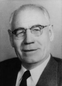
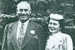
John Hugo Aronson Famous memorial
| Birth | : | 1 Sep 1891 Gällstad, Ulricehamns kommun, Västra Götalands län, Sweden |
| Death | : | 25 Feb 1978 Columbia Falls, Flathead County, Montana, USA |
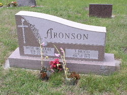
| Burial | : | Riverview Cemetery, Hamilton, Ravalli County, USA |
| Coordinate | : | 46.2456017, -114.1803970 |
| Description | : | Montana Governor. Immigrating to the United States in 1911, he established an oil rigging business in Montana and discovered an oil field in Toole County, in 1922, which became the state’s richest natural gas and oil fields. He also had a successful trucking business advertised as, "The Galloping Swede". Entering politics, he was as an alderman of the Cut Bank City Council, (1934-38), a member of the Montana State House of Representatives, in 1938 and a member of the Montana State Senate, in 1944. In 1953, he was elected as a Republican the 14th Governor of Montana, serving until 1961.... Read More |
frequently asked questions (FAQ):
-
Where is John Hugo Aronson Famous memorial's memorial?
John Hugo Aronson Famous memorial's memorial is located at: Riverview Cemetery, Hamilton, Ravalli County, USA.
-
When did John Hugo Aronson Famous memorial death?
John Hugo Aronson Famous memorial death on 25 Feb 1978 in Columbia Falls, Flathead County, Montana, USA
-
Where are the coordinates of the John Hugo Aronson Famous memorial's memorial?
Latitude: 46.2456017
Longitude: -114.1803970
Family Members:
Spouse
Flowers:


Nearby Cemetories:
1. Riverview Cemetery
Hamilton, Ravalli County, USA
Coordinate: 46.2456017, -114.1803970
2. Blodgett Cemetery
Ravalli County, USA
Coordinate: 46.2886009, -114.1868973
3. Grantsdale Cemetery
Hamilton, Ravalli County, USA
Coordinate: 46.1819000, -114.1442032
4. Corvallis Cemetery
Corvallis, Ravalli County, USA
Coordinate: 46.2991982, -114.1003036
5. Pinesdale Cemetery
Pinesdale, Ravalli County, USA
Coordinate: 46.3255100, -114.2134000
6. Victor Cemetery
Victor, Ravalli County, USA
Coordinate: 46.4268610, -114.1568680
7. Lone Pine Cemetery
Darby, Ravalli County, USA
Coordinate: 46.0289001, -114.1742020
8. Riverside Cemetery
Stevensville, Ravalli County, USA
Coordinate: 46.4986000, -114.0982971
9. Maplewood Cemetery
Stevensville, Ravalli County, USA
Coordinate: 46.5042000, -114.0963974
10. Saint Marys Cemetery
Stevensville, Ravalli County, USA
Coordinate: 46.5093994, -114.0986023
11. Sunnyside Cemetery
Stevensville, Ravalli County, USA
Coordinate: 46.5657997, -113.9916992
12. Saint Josephs Cemetery
Florence, Ravalli County, USA
Coordinate: 46.6294000, -114.0861000
13. Sula Cemetery
Sula, Ravalli County, USA
Coordinate: 45.8591995, -113.9777985
14. Tolan Creek Cemetery
Sula, Ravalli County, USA
Coordinate: 45.8560318, -113.9134116
15. Carlton Cemetery
Lolo, Missoula County, USA
Coordinate: 46.6788880, -114.0791560
16. Brickley Cemetery
Darby, Ravalli County, USA
Coordinate: 45.7648000, -114.2786900
17. Woodman Pioneer Cemetery
Lolo, Missoula County, USA
Coordinate: 46.7675000, -114.2676000
18. Colgate Gravesite
Idaho County, USA
Coordinate: 46.4640000, -114.9401500
19. Fort Missoula Cemetery
Missoula, Missoula County, USA
Coordinate: 46.8469009, -114.0570984
20. Western Montana State Veterans Cemetery
Missoula, Missoula County, USA
Coordinate: 46.8531100, -114.0563600
21. Philipsburg Cemetery
Philipsburg, Granite County, USA
Coordinate: 46.3408990, -113.2961010
22. Holy Spirit Episcopal Church Columbarium
Missoula, Missoula County, USA
Coordinate: 46.8642000, -113.9963000
23. Sunset Memorial Gardens
Missoula, Missoula County, USA
Coordinate: 46.8902779, -114.1001740
24. Saint Mary Cemetery
Missoula, Missoula County, USA
Coordinate: 46.8865070, -113.9995050