
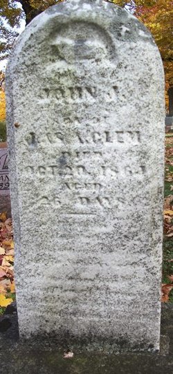
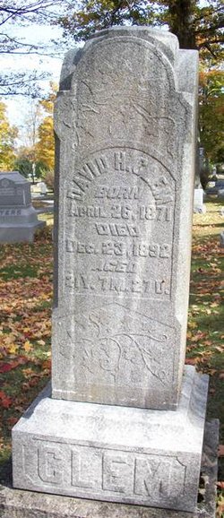
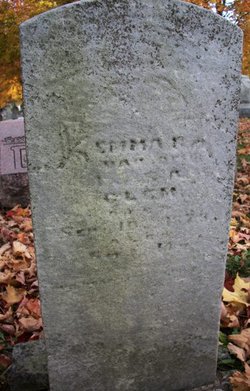
John J Clem
| Birth | : | 24 Sep 1864 Champaign County, Ohio, USA |
| Death | : | 20 Oct 1864 Champaign County, Ohio, USA |
| Burial | : | Swiftwater Cemetery, Bath, Grafton County, USA |
| Coordinate | : | 44.1303400, -71.9574300 |
| Description | : | Inscription: Son of I & SA Clem -- Aged 26 days |
frequently asked questions (FAQ):
-
Where is John J Clem's memorial?
John J Clem's memorial is located at: Swiftwater Cemetery, Bath, Grafton County, USA.
-
When did John J Clem death?
John J Clem death on 20 Oct 1864 in Champaign County, Ohio, USA
-
Where are the coordinates of the John J Clem's memorial?
Latitude: 44.1303400
Longitude: -71.9574300
Family Members:
Parent
Siblings
Flowers:


Nearby Cemetories:
1. Swiftwater Cemetery
Bath, Grafton County, USA
Coordinate: 44.1303400, -71.9574300
2. Bath Village Cemetery
Bath, Grafton County, USA
Coordinate: 44.1693500, -71.9617800
3. Pine Grove Cemetery
Woodsville, Grafton County, USA
Coordinate: 44.1380997, -72.0188980
4. West Cemetery
Benton, Grafton County, USA
Coordinate: 44.1033700, -71.9014000
5. West Bath Cemetery
Bath, Grafton County, USA
Coordinate: 44.1750930, -71.9865080
6. Center Haverhill Cemetery
Center Haverhill, Grafton County, USA
Coordinate: 44.0770650, -71.9868740
7. East Cemetery
Benton, Grafton County, USA
Coordinate: 44.0985985, -71.8846970
8. Horse Meadow Cemetery
North Haverhill, Grafton County, USA
Coordinate: 44.1068880, -72.0405500
9. Horse Meadow Annex Cemetery
North Haverhill, Grafton County, USA
Coordinate: 44.1056820, -72.0408260
10. Abbott Cemetery
North Haverhill, Grafton County, USA
Coordinate: 44.0821730, -72.0186420
11. Landaff Center Cemetery
Landaff, Grafton County, USA
Coordinate: 44.1739860, -71.8847040
12. Pettyboro District Cemetery
Pettyboro, Grafton County, USA
Coordinate: 44.2038310, -71.9620880
13. Wells River Cemetery
Wells River, Orange County, USA
Coordinate: 44.1535988, -72.0547028
14. Carbee Cemetery
Bath, Grafton County, USA
Coordinate: 44.1724640, -72.0466980
15. Oxbow Cemetery
Newbury, Orange County, USA
Coordinate: 44.0881830, -72.0486670
16. Saint Joseph Cemetery
Bath, Grafton County, USA
Coordinate: 44.1803017, -72.0524979
17. Grove Hill Cemetery
Lisbon, Grafton County, USA
Coordinate: 44.2108002, -71.9094009
18. Carbee District Cemetery
Bath, Grafton County, USA
Coordinate: 44.1881040, -72.0521310
19. Upper Smith Road Cemetery
Bath, Grafton County, USA
Coordinate: 44.2202780, -72.0075000
20. Boltonville Cemetery
Boltonville, Orange County, USA
Coordinate: 44.1575012, -72.0877991
21. Number 6 Cemetery
East Haverhill, Grafton County, USA
Coordinate: 44.0326400, -71.9518600
22. Brown Farmstead Cemetery
Benton, Grafton County, USA
Coordinate: 44.0778000, -71.8420830
23. Bedel Cemetery
Bath, Grafton County, USA
Coordinate: 44.2075000, -72.0455560
24. East Haverhill Cemetery
East Haverhill, Grafton County, USA
Coordinate: 44.0289688, -71.9889297