
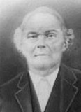

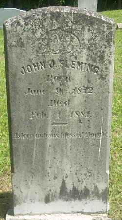

John Jackson “Jack” Fleming
| Birth | : | 9 Jun 1812 Lee County, Virginia, USA |
| Death | : | 1 Feb 1881 Clintwood, Dickenson County, Virginia, USA |
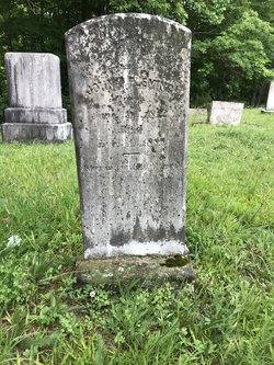
| Burial | : | Bethesda Southern Methodist Church Cemetery, Oak Grove, Dillon County, USA |
| Coordinate | : | 34.3520279, -79.5437164 |
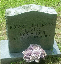
| Description | : | Born in Powell's Valley, Lee Co. Va., decendant of Robert Fleming & Elizabeth Stambaugh. Served under Menifee & Prentice during the civil war.Married Mary Mullins ,1/31/1883, d/o Holly Creek John & Ollie(Cox) Mullins .This couple reared 12 children. He married Mary Mullins about the year 1832, she being about 17 years old. He settled first on Jack's Ford (Named after him) of Beaver Creek in Floyd County, Kentucky. After his first two children were born, he moved to Flemingtown, Va., where he lived on a farm the rest of his life. He was buried there.... Read More |
frequently asked questions (FAQ):
-
Where is John Jackson “Jack” Fleming's memorial?
John Jackson “Jack” Fleming's memorial is located at: Bethesda Southern Methodist Church Cemetery, Oak Grove, Dillon County, USA.
-
When did John Jackson “Jack” Fleming death?
John Jackson “Jack” Fleming death on 1 Feb 1881 in Clintwood, Dickenson County, Virginia, USA
-
Where are the coordinates of the John Jackson “Jack” Fleming's memorial?
Latitude: 34.3520279
Longitude: -79.5437164
Family Members:
Parent
Spouse
Siblings
Children

Flowers:


Nearby Cemetories:
1. Bethesda Southern Methodist Church Cemetery
Oak Grove, Dillon County, USA
Coordinate: 34.3520279, -79.5437164
2. Little Bless Holiness Church Cemetery
Oak Grove, Dillon County, USA
Coordinate: 34.3515930, -79.5420761
3. Shiloh Chapel Cemetery
Oak Grove, Dillon County, USA
Coordinate: 34.3574140, -79.5474310
4. Tart Cemetery
Dillon County, USA
Coordinate: 34.3537000, -79.5582000
5. Oak Grove Church of God Cemetery
Oak Grove, Dillon County, USA
Coordinate: 34.3629760, -79.5539220
6. Mill Branch Baptist Church Cemetery
Oak Grove, Dillon County, USA
Coordinate: 34.3407160, -79.5315500
7. Smith Hayes Cemetery
Latta, Dillon County, USA
Coordinate: 34.3560000, -79.5775000
8. Mallory Church Of God
Mallory, Dillon County, USA
Coordinate: 34.3801180, -79.5201940
9. Catfish Creek Baptist Church Cemetery
Latta, Dillon County, USA
Coordinate: 34.3652000, -79.4918976
10. Timothy Rogers Cemetery
Dillon County, USA
Coordinate: 34.4008000, -79.5516000
11. Cain Cemetery
Mallory, Dillon County, USA
Coordinate: 34.4009960, -79.5519800
12. Union Cemetery
Latta, Dillon County, USA
Coordinate: 34.3167000, -79.5014038
13. East Marlboro Baptist Church Cemetery
Brownsville, Marlboro County, USA
Coordinate: 34.3889430, -79.5913500
14. McDowell Memorial Cemetery
Marlboro County, USA
Coordinate: 34.3956800, -79.5823200
15. Trinity Holiness Church Cemetery
Latta, Dillon County, USA
Coordinate: 34.3646049, -79.4764709
16. Bethlehem Methodist Cemetery
Brownsville, Marlboro County, USA
Coordinate: 34.3910500, -79.5981090
17. Bethea Cemetery
Dillon County, USA
Coordinate: 34.3377991, -79.4732971
18. Bethea Cemetery
Latta, Dillon County, USA
Coordinate: 34.3851000, -79.4678500
19. Mace Cemetery
Dillon County, USA
Coordinate: 34.2924995, -79.4803009
20. Haselden Cemetery
Dillon County, USA
Coordinate: 34.2743800, -79.5234000
21. Lane Cemetery
Latta, Dillon County, USA
Coordinate: 34.3292007, -79.4514008
22. Bethel Hill Cemetery
Latta, Dillon County, USA
Coordinate: 34.3741989, -79.4471970
23. Sweat Cemetery
Dillon County, USA
Coordinate: 34.3181000, -79.4499969
24. Sweat Cemetery
Latta, Dillon County, USA
Coordinate: 34.3178800, -79.4489400