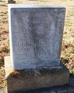
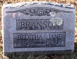
John Jefferson Branson
| Birth | : | 17 Mar 1851 Byron, Osage County, Missouri, USA |
| Death | : | 26 Jun 1924 Osage County, Missouri, USA |
| Burial | : | Mount Zion Cemetery, Fonda, Pocahontas County, USA |
| Coordinate | : | 42.5821991, -94.8300018 |
| Description | : | John Jefferson Branson was the son of Madison Sanders Branson, born: June 28, 1821. John married Beditha Jane Boyse. |
frequently asked questions (FAQ):
-
Where is John Jefferson Branson's memorial?
John Jefferson Branson's memorial is located at: Mount Zion Cemetery, Fonda, Pocahontas County, USA.
-
When did John Jefferson Branson death?
John Jefferson Branson death on 26 Jun 1924 in Osage County, Missouri, USA
-
Where are the coordinates of the John Jefferson Branson's memorial?
Latitude: 42.5821991
Longitude: -94.8300018
Family Members:
Flowers:
Nearby Cemetories:
1. Mount Zion Cemetery
Fonda, Pocahontas County, USA
Coordinate: 42.5821991, -94.8300018
2. Cedar Township Cemetery
Fonda, Pocahontas County, USA
Coordinate: 42.5810000, -94.8375000
3. Saint Columbkilles Cemetery
Varina, Pocahontas County, USA
Coordinate: 42.6467018, -94.8443985
4. Varina Cemetery
Newell Township, Buena Vista County, USA
Coordinate: 42.6539993, -94.9339981
5. Saint Marys Catholic Cemetery
Pomeroy, Calhoun County, USA
Coordinate: 42.5558014, -94.6889038
6. Dover Township Cemetery
Varina, Pocahontas County, USA
Coordinate: 42.6896100, -94.8524200
7. Elfsborg Lutheran Cemetery
Palmer, Pocahontas County, USA
Coordinate: 42.6169014, -94.6875000
8. Saint John Cemetery
Williams Township, Calhoun County, USA
Coordinate: 42.4747009, -94.8672028
9. Union Cemetery
Pomeroy, Calhoun County, USA
Coordinate: 42.5539017, -94.6789017
10. Evangelical Covenant Cemetery
Pomeroy, Calhoun County, USA
Coordinate: 42.6165720, -94.6803640
11. Swedish Mission Bethany Cemetery
Pocahontas County, USA
Coordinate: 42.6138992, -94.6774979
12. Grant Township Cemetery
Pocahontas, Pocahontas County, USA
Coordinate: 42.6571999, -94.6996994
13. Crown Hill Cemetery
Jolley, Calhoun County, USA
Coordinate: 42.4808006, -94.7360992
14. Newell Cemetery
Newell, Buena Vista County, USA
Coordinate: 42.6123800, -94.9994800
15. Cedar Cemetery
Sac City, Sac County, USA
Coordinate: 42.4430000, -94.9110000
16. Newell Catholic Prairie Cemetery
Newell, Buena Vista County, USA
Coordinate: 42.6144000, -95.0328000
17. Garfield Cemetery
Calhoun County, USA
Coordinate: 42.4275017, -94.7902985
18. Saint Josephs Cemetery
Palmer, Pocahontas County, USA
Coordinate: 42.6342010, -94.6188965
19. Donna Lynn Salis-Christensen Burial Plot
Newell, Buena Vista County, USA
Coordinate: 42.5882134, -95.0544960
20. Memorial Park Cemetery
Calhoun County, USA
Coordinate: 42.5189018, -94.6194000
21. Twin Lakes Cemetery
Jolley, Calhoun County, USA
Coordinate: 42.4427986, -94.6889038
22. Swedish Cemetery
Manson, Calhoun County, USA
Coordinate: 42.5426295, -94.5992013
23. Palmer Cemetery
Palmer, Pocahontas County, USA
Coordinate: 42.6166992, -94.5894012
24. Saint Paul Lutheran Cemetery
Palmer, Pocahontas County, USA
Coordinate: 42.6176000, -94.5893500


