
| Birth | : | 24 Jun 1863 Moniteau County, Missouri, USA |
| Death | : | 5 May 1938 Columbia, Boone County, Missouri, USA |
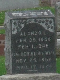
| Burial | : | New Liberty Cemetery, Ashland, Boone County, USA |
| Coordinate | : | 38.7690300, -92.2809800 |
| Description | : | Death certificate lists his parents as William and Katherine Yoest of Germany. It lists his birth year as 1865 rather than 1863. |
frequently asked questions (FAQ):
-
Where is John Joseph Yoest's memorial?
John Joseph Yoest's memorial is located at: New Liberty Cemetery, Ashland, Boone County, USA.
-
When did John Joseph Yoest death?
John Joseph Yoest death on 5 May 1938 in Columbia, Boone County, Missouri, USA
-
Where are the coordinates of the John Joseph Yoest's memorial?
Latitude: 38.7690300
Longitude: -92.2809800
Family Members:
Parent

Spouse
Siblings
Children
Flowers:


Nearby Cemetories:
1. Woodcrest Primitive Baptist Church Cemetery
Ashland, Boone County, USA
Coordinate: 38.7708400, -92.2588100
2. Forbis Cemetery
Ashland, Boone County, USA
Coordinate: 38.7847100, -92.2987200
3. Woodcrest Cemetery
Ashland, Boone County, USA
Coordinate: 38.7819730, -92.2532270
4. New Salem Baptist Church Cemetery
Ashland, Boone County, USA
Coordinate: 38.7996330, -92.2521973
5. Oakland M E Church Cemetery
Boone County, USA
Coordinate: 38.8182600, -92.3077100
6. Bonds Chapel Cemetery
Hartsburg, Boone County, USA
Coordinate: 38.7093900, -92.2855200
7. Goshen Primitive Baptist Church Cemetery
Wilton, Boone County, USA
Coordinate: 38.7346600, -92.3550000
8. Log Providence Cemetery
Columbia, Boone County, USA
Coordinate: 38.8403931, -92.2746658
9. Friedens Cemetery
Hartsburg, Boone County, USA
Coordinate: 38.6986000, -92.3087000
10. Nashville Cemetery
Sapp, Boone County, USA
Coordinate: 38.8243484, -92.3498764
11. Mount Pleasant Cemetery
Hartsburg, Boone County, USA
Coordinate: 38.6903000, -92.2577972
12. Holt Cemetery
New Bloomfield, Callaway County, USA
Coordinate: 38.7339400, -92.1840100
13. Mount Zion Cemetery
Callaway County, USA
Coordinate: 38.7005997, -92.2093964
14. Turner Family Cemetery # 1
Columbia, Boone County, USA
Coordinate: 38.8482600, -92.3344600
15. Harris Cemetery
Boone County, USA
Coordinate: 38.8555984, -92.2500000
16. Bullard-Barger Family Cemetery
Boone County, USA
Coordinate: 38.8168983, -92.1753006
17. Shull Cemetery
Moniteau County, USA
Coordinate: 38.7296982, -92.3972015
18. Old Marion Cemetery
Marion, Cole County, USA
Coordinate: 38.7065506, -92.3792801
19. Shull Cemetery
Cole County, USA
Coordinate: 38.7296982, -92.3974991
20. Rock Bridge Cemetery
Boone County, USA
Coordinate: 38.8689003, -92.3000031
21. John D. Williams Cemetery
Sandy Hook, Moniteau County, USA
Coordinate: 38.7545600, -92.4098800
22. Dry Fork Cemetery
Guthrie, Callaway County, USA
Coordinate: 38.7607002, -92.1496964
23. Oak Chapel Cemetery
Guthrie, Callaway County, USA
Coordinate: 38.7606430, -92.1494064
24. Cook Cemetery
Moniteau County, USA
Coordinate: 38.7393990, -92.4080963