
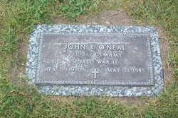
John L O'Neal
| Birth | : | 5 Apr 1920 Dighton, Lane County, Kansas, USA |
| Death | : | 21 May 1985 Sterling, Logan County, Colorado, USA |
| Burial | : | Woodland Cemetery, Ironton, Lawrence County, USA |
| Coordinate | : | 38.5069008, -82.6502991 |
| Plot | : | Sermon on the Mount Garden Lot 38 |
| Description | : | John L. O'Neal, 65 of 301 Platte St., died Tuesday in a Sterling nursing home. Closed casket funeral services will be 10 a.m. Thursday from Hettinger Funeral home, the Rev. Dr. Ivan E. Rundus officiating. Burial will follow in Sunset Memorial Gardens. Mr. O'Neal was born April 5, 1920, in Dighton, Kan., to John and Myrtle Yates O'Neal. He was reared in Kansas and moved to McAllen, Texas in 1959. In February of 1943 he married Doris Gray in Sault Ste. Marie, Mich. Mr. O'Neal moved to Sterling in 1968. He was a car salesman at Leon Larson Ford and... Read More |
frequently asked questions (FAQ):
-
Where is John L O'Neal's memorial?
John L O'Neal's memorial is located at: Woodland Cemetery, Ironton, Lawrence County, USA.
-
When did John L O'Neal death?
John L O'Neal death on 21 May 1985 in Sterling, Logan County, Colorado, USA
-
Where are the coordinates of the John L O'Neal's memorial?
Latitude: 38.5069008
Longitude: -82.6502991
Family Members:
Parent

Spouse
Siblings
Children
Flowers:


Nearby Cemetories:
1. Woodland Cemetery
Ironton, Lawrence County, USA
Coordinate: 38.5069008, -82.6502991
2. Calvary Cemetery
Coal Grove, Lawrence County, USA
Coordinate: 38.5056000, -82.6474991
3. Newton Cemetery
Coal Grove, Lawrence County, USA
Coordinate: 38.5024986, -82.6492004
4. Zoar Cemetery
Coal Grove, Lawrence County, USA
Coordinate: 38.5010986, -82.6280975
5. Sheeler Cemetery
Bellefonte, Greenup County, USA
Coordinate: 38.4962279, -82.6763369
6. W.D. Kelly Cemetery
Ironton, Lawrence County, USA
Coordinate: 38.5284700, -82.6661200
7. Beech Grove Cemetery
Ashland, Boyd County, USA
Coordinate: 38.4802610, -82.6483320
8. Crabtree Family Cemetery
Kitts Hill, Lawrence County, USA
Coordinate: 38.4907280, -82.6183990
9. Calvary Catholic Cemetery
Ashland, Boyd County, USA
Coordinate: 38.4742012, -82.6519012
10. Bethesda Cemetery
Ashland, Boyd County, USA
Coordinate: 38.4721500, -82.6491510
11. Pollard Cemetery
Ashland, Boyd County, USA
Coordinate: 38.4717920, -82.6617380
12. Sacred Heart Cemetery
Ironton, Lawrence County, USA
Coordinate: 38.5447006, -82.6631012
13. Community Cemetery
Deering, Lawrence County, USA
Coordinate: 38.5010250, -82.6005050
14. Hecla Cemetery
Hecla, Lawrence County, USA
Coordinate: 38.5492700, -82.6433400
15. Sugar Creek Cemetery
Ironton, Lawrence County, USA
Coordinate: 38.5467700, -82.6282000
16. Bellefonte Memorial Gardens
Flatwoods, Greenup County, USA
Coordinate: 38.5153008, -82.7052994
17. Palmer Cemetery
Flatwoods, Greenup County, USA
Coordinate: 38.5141983, -82.7055969
18. Gallaher Cemetery
Ashland, Boyd County, USA
Coordinate: 38.4622820, -82.6524240
19. Allen-Smallwood Cemetery
Boyd County, USA
Coordinate: 38.4625772, -82.6754914
20. Henry Cemetery
Ironton, Lawrence County, USA
Coordinate: 38.5476190, -82.6855840
21. Ashland Cemetery
Ashland, Boyd County, USA
Coordinate: 38.4597850, -82.6313980
22. McKnight Cemetery
Boyd County, USA
Coordinate: 38.4777985, -82.7022018
23. Brickey Cemetery
Boyd County, USA
Coordinate: 38.4563900, -82.6577800
24. Rose Hill Burial Park and Mausoleum
Ashland, Boyd County, USA
Coordinate: 38.4557991, -82.6718979