
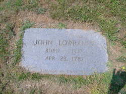
John Lowrance
| Birth | : | 1717 |
| Death | : | 23 Apr 1781 Rowan County, North Carolina, USA |
| Burial | : | Saint John Lutheran Cemetery, Luana, Clayton County, USA |
| Coordinate | : | 43.0628000, -91.4546000 |
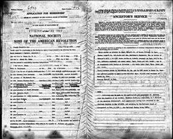
| Description | : | From "Heritage of Rowan County, North Carolina: In 1756 each of them (John and Alexander) bought land in what was then the western frontier.Alexander bought 524 acres of land on Beaverdam Branch of Withrow's Creek and John purchased 632 acres on Sills Creek. All of their property was in Rowan County, but in that section that later became Iredell and Catawba counties. Most of the records on the early years of the Lowrances in North Carolina can be found in the courthouses and libraries of Rowan, Iredell, Lincoln, Burke and Catawba counties. Lain, Lowrance and Related Families: John was... Read More |
frequently asked questions (FAQ):
-
Where is John Lowrance's memorial?
John Lowrance's memorial is located at: Saint John Lutheran Cemetery, Luana, Clayton County, USA.
-
When did John Lowrance death?
John Lowrance death on 23 Apr 1781 in Rowan County, North Carolina, USA
-
Where are the coordinates of the John Lowrance's memorial?
Latitude: 43.0628000
Longitude: -91.4546000
Family Members:
Parent
Spouse
Siblings
Children

Flowers:


Nearby Cemetories:
1. Saint John Lutheran Cemetery
Luana, Clayton County, USA
Coordinate: 43.0628000, -91.4546000
2. Luana Cemetery
Luana, Clayton County, USA
Coordinate: 43.0602989, -91.4682999
3. Hardin Cemetery
Allamakee County, USA
Coordinate: 43.0889015, -91.4863968
4. Grand Meadow Cemetery
Luana, Clayton County, USA
Coordinate: 43.0628014, -91.5081024
5. Pioneer Cemetery
Monona, Clayton County, USA
Coordinate: 43.0149994, -91.4274979
6. Saint Patricks Cemetery
Monona, Clayton County, USA
Coordinate: 43.0496000, -91.3850000
7. Saint Paul Lutheran Cemetery
Monona, Clayton County, USA
Coordinate: 43.0494385, -91.3847198
8. Monona Cemetery
Monona, Clayton County, USA
Coordinate: 43.0531006, -91.3799973
9. Cummings Plot
Volney, Allamakee County, USA
Coordinate: 43.0916484, -91.3834702
10. Fry Family Cemetery
Farmersburg, Clayton County, USA
Coordinate: 43.0152530, -91.5182350
11. Eno Cemetery
Wagner Township, Clayton County, USA
Coordinate: 42.9930992, -91.4693985
12. Smithfield Cemetery
Volney, Allamakee County, USA
Coordinate: 43.1255989, -91.3899994
13. Gooding Cemetery
Wagner Township, Clayton County, USA
Coordinate: 42.9869490, -91.4191570
14. Postville Cemetery
Clayton County, USA
Coordinate: 43.0811081, -91.5655594
15. Minert Cemetery
Postville, Allamakee County, USA
Coordinate: 43.1161003, -91.5488968
16. Volney Cemetery
Allamakee County, USA
Coordinate: 43.1305618, -91.3722229
17. Bailey Plot
Volney, Allamakee County, USA
Coordinate: 43.1499799, -91.4168047
18. Marion Lutheran Cemetery
Gunder, Clayton County, USA
Coordinate: 42.9708290, -91.5127792
19. Saint Wenceslaus Cemetery
McGregor, Clayton County, USA
Coordinate: 43.0593987, -91.3142014
20. Cleveland Cemetery
Postville, Allamakee County, USA
Coordinate: 43.1631000, -91.4930000
21. Smith Cemetery
Allamakee County, USA
Coordinate: 43.1539001, -91.5267029
22. Railroad Employee Cemetery
Giard, Clayton County, USA
Coordinate: 43.0305395, -91.3140229
23. Wagner Township Cemetery
Saint Olaf, Clayton County, USA
Coordinate: 42.9519386, -91.4513931
24. Council Hill Cemetery
Monona, Clayton County, USA
Coordinate: 43.0718994, -91.3000031